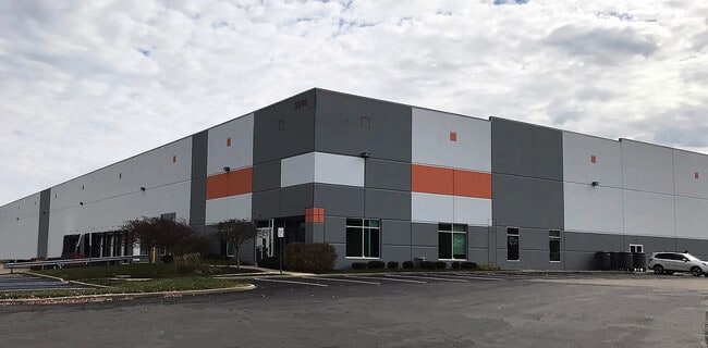
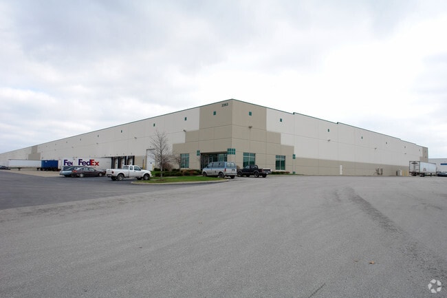
Property Record
2363 E Perry Rd, Plainfield, IN 46168

Property Detail
2363 E Perry Rd
Indianapolis-Carmel-Greenwood, IN
PLAINFIELD PARK SEC 2 LOT 20 21.63AC
32-16-06-320-001.000-012
Hendricks
Warehouse
Indiana
B and X Area of moderate flood hazard, usually the area between the limits of the 100-year and 500-year floods.
20
2025
21.63 AC
2025
Plainfield
210607
Indianapolis
346,808 SF
NEARBY LISTINGS FOR SALE OR LEASE
DEMOGRAPHICS near 2363 E Perry Rd
1 mile
3 mile
5 mile
2025 Total Population
440
25,621
83,296
2030 Population
473
27,336
87,771
Pop Growth 2025-2030
+ 7.50%
+ 6.69%
+ 5.37%
Average Age
41
40
39
2025 Total Households
169
9,567
30,436
HH Growth 2025-2030
+ 7.69%
+ 7.29%
+ 5.71%
Median Household Inc
$98,648
$77,625
$86,004
Avg Household Size
2.50
2.30
2.60
2025 Avg HH Vehicles
2.00
2.00
2.00
Median Home Value
$273,333
$252,924
$269,860
Median Year Built
1987
1983
1997
Nearby Places
Map Layers
Map Styles
 Street
 Aerial
Layers
 Traffic
 Biking
Places
Listings with unknown addresses are not visible on the map
- Restaurants
- Banks
- Shops
- Fitness
- Groceries
PUBLIC TRANSPORTATION
AIRPORT
Indianapolis International
Drive
Walk
Distance
Indianapolis International
14 min
6.8 mi
Freight Ports
Port of Toledo
Drive
Walk
Distance
Port of Toledo
292 min
241.7 mi
SALE & LEASE HISTORY
LISTING DATE
SALE/LEASE

Sep 24, 2016
For Lease
Sep 12, 2018
For Lease
Jan 16, 2020
For Lease
Nearby Properties
Address
Land Use
TOTAL SIZE
Lot Size
Zoning
Address
Land Use
TOTAL SIZE
Lot Size
Zoning
911,062 SF
54.40 AC
ZO01
Address
Land Use
TOTAL SIZE
Lot Size
Zoning
41.50 AC
Address
Land Use
TOTAL SIZE
Lot Size
Zoning
796,988 SF
48.51 AC
Address
Land Use
TOTAL SIZE
Lot Size
Zoning
950,625 SF
58.11 AC
Address
Land Use
TOTAL SIZE
Lot Size
Zoning
923,980 SF
60.08 AC
Address
Land Use
TOTAL SIZE
Lot Size
Zoning
822,500 SF
45.66 AC
Address
Land Use
TOTAL SIZE
Lot Size
Zoning
770,712 SF
56.53 AC
Address
Land Use
TOTAL SIZE
Lot Size
Zoning
9,728 SF
23.10 AC
Address
Land Use
TOTAL SIZE
Lot Size
Zoning
799,264 SF
43.44 AC
Address
Land Use
TOTAL SIZE
Lot Size
Zoning
629,200 SF
39.74 AC
Address
Land Use
TOTAL SIZE
Lot Size
Zoning
813,054 SF
45.32 AC
Address
Land Use
TOTAL SIZE
Lot Size
Zoning
750,820 SF
64.15 AC
Address
Land Use
TOTAL SIZE
Lot Size
Zoning
720,000 SF
39.03 AC
Address
Land Use
TOTAL SIZE
Lot Size
Zoning
747,256 SF
41.32 AC
Address
Land Use
TOTAL SIZE
Lot Size
Zoning
5,064 SF
25.50 AC
Address
Land Use
TOTAL SIZE
Lot Size
Zoning
595,938 SF
35.31 AC
Address
Land Use
TOTAL SIZE
Lot Size
Zoning
665,724 SF
47.25 AC
ZO01
Address
Land Use
TOTAL SIZE
Lot Size
Zoning
695,702 SF
39.68 AC
ZO03
Address
Land Use
TOTAL SIZE
Lot Size
Zoning
51,884 SF
14.73 AC
Address
Land Use
TOTAL SIZE
Lot Size
Zoning
24.62 AC
Address
Land Use
TOTAL SIZE
Lot Size
Zoning
651,610 SF
63.52 AC
Address
Land Use
TOTAL SIZE
Lot Size
Zoning
650,960 SF
31.95 AC
Address
Land Use
TOTAL SIZE
Lot Size
Zoning
292,315 SF
28.97 AC
Address
Land Use
TOTAL SIZE
Lot Size
Zoning
635,585 SF
28.37 AC
Address
Land Use
TOTAL SIZE
Lot Size
Zoning
462,275 SF
25.83 AC
ZO01
Address
Land Use
TOTAL SIZE
Lot Size
Zoning
10,953 SF
18.52 AC
Address
Land Use
TOTAL SIZE
Lot Size
Zoning
551,424 SF
31.39 AC
Address
Land Use
TOTAL SIZE
Lot Size
Zoning
518,536 SF
25.66 AC
Address
Land Use
TOTAL SIZE
Lot Size
Zoning
599,744 SF
34.65 AC
Address
Land Use
TOTAL SIZE
Lot Size
Zoning
500,192 SF
33.15 AC
The World's #1 Commercial Real Estate Marketplace
Connect with us
© 2026 CoStar Group
The information above has been obtained from sources believed reliable. While we do not doubt its accuracy we have not verified it and make no guarantee, warranty or representation about it. It is your responsibility to independently confirm its accuracy and completeness. Any projections, opinions, assumptions, or estimates used are for example only and do not represent the current or future performance of the property. The value of this transaction to you depends on tax and other factors which should be evaluated by your tax, financial, and legal advisors. You and your advisors should conduct a careful, independent investigation of the property to determine to your satisfaction the suitability of the property for your needs.