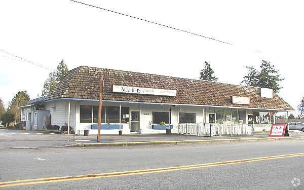
Property Record
23631 Brier Rd, Brier, WA 98036
NEARBY LISTINGS FOR SALE OR LEASE
Property Detail
23631 Brier Rd
Seattle-Tacoma-Bellevue, WA
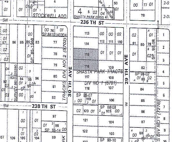
Shasta Park Tracts 1
005701-000-115-00
SHASTA PARK TRACTS 1 BLK 000 D-00 - TR 115
Storebuilding
Snohomish
X
Washington
53061C1317F
115
2024
0.52 AC
2025
Bothell/Kenmore
0519144010
Seattle/Puget Sound
DEMOGRAPHICS near 23631 Brier Rd
1 Mile
3 Mile
5 Mile
2024 Total Population
11,688
122,108
369,811
2029 Population
11,997
126,078
381,195
Pop Growth 2024-2029
+ 2.64%
+ 3.25%
+ 3.08%
Average Age
42
40
40
2024 Total Households
4,458
47,651
145,882
HH Growth 2024-2029
+ 2.76%
+ 3.25%
+ 3.11%
Median Household Inc
$131,028
$108,340
$107,487
Avg Household Size
2.60
2.50
2.50
2024 Avg HH Vehicles
2.00
2.00
2.00
Median Home Value
$741,973
$730,819
$747,229
Median Year Built
1981
1979
1981
Nearby Places
Map Layers
Map Styles
 Street
 Aerial
- Restaurants
- Banks
- Shops
- Fitness
- Groceries
PUBLIC TRANSPORTATION
COMMUTER RAIL
Edmonds Station (Sounder South Line - Central Puget Sound Regional Transit Authority Rail (Link Light Rail/Sounder))
DRIVE
WALK
Distance
Edmonds Station (Sounder South Line - Central Puget Sound Regional Transit Authority Rail (Link Light Rail/Sounder))
18 min
8.0 mi
AIRPORT
Seattle Paine Field International
DRIVE
WALK
Distance
Seattle Paine Field International
21 min
10.5 mi
Seattle-Tacoma International
DRIVE
WALK
Distance
Seattle-Tacoma International
46 min
29.8 mi
Freight Ports
Port of Everett
DRIVE
WALK
Distance
Port of Everett
26 min
15.8 mi
Nearby Properties
Address
Land Use
TOTAL SIZE
Lot Size
Zoning
Address
Land Use
TOTAL SIZE
Lot Size
Zoning
444,231 SF
31.50 AC
SDD/R
Address
Land Use
TOTAL SIZE
Lot Size
Zoning
400,610 SF
77.69 AC
R6
Address
Land Use
TOTAL SIZE
Lot Size
Zoning
472,109 SF
3.89 AC
F/T
Address
Land Use
TOTAL SIZE
Lot Size
Zoning
430,882 SF
34.07 AC
LI/OP
Address
Land Use
TOTAL SIZE
Lot Size
Zoning
314,593 SF
2.39 AC
UC
Address
Land Use
TOTAL SIZE
Lot Size
Zoning
304,881 SF
2.30 AC
F/T
Address
Land Use
TOTAL SIZE
Lot Size
Zoning
366,782 SF
19.24 AC
RMM
Address
Land Use
TOTAL SIZE
Lot Size
Zoning
514,225 SF
11.96 AC
CC-W
Address
Land Use
TOTAL SIZE
Lot Size
Zoning
421,873 SF
9.06 AC
PCD
Address
Land Use
TOTAL SIZE
Lot Size
Zoning
394,152 SF
18 AC
E-M
Address
Land Use
TOTAL SIZE
Lot Size
Zoning
337,473 SF
1.74 AC
CC-C
Address
Land Use
TOTAL SIZE
Lot Size
Zoning
24,833 SF
2.48 AC
CC-C
Address
Land Use
TOTAL SIZE
Lot Size
Zoning
131,236 SF
19.14 AC
R6
Address
Land Use
TOTAL SIZE
Lot Size
Zoning
187,893 SF
12.83 AC
CC-C
Address
Land Use
TOTAL SIZE
Lot Size
Zoning
223,338 SF
2.05 AC
F/T
Address
Land Use
TOTAL SIZE
Lot Size
Zoning
168,518 SF
0.51 AC
MR
Address
Land Use
TOTAL SIZE
Lot Size
Zoning
185,598 SF
9.52 AC
RMM
Address
Land Use
TOTAL SIZE
Lot Size
Zoning
222,333 SF
36.10 AC
E-M
Address
Land Use
TOTAL SIZE
Lot Size
Zoning
435,040 SF
2.45 AC
ACC
Address
Land Use
TOTAL SIZE
Lot Size
Zoning
28.93 AC
RS 8400
Address
Land Use
TOTAL SIZE
Lot Size
Zoning
220,968 SF
16.46 AC
TC
Address
Land Use
TOTAL SIZE
Lot Size
Zoning
237,329 SF
14.25 AC
RML
Address
Land Use
TOTAL SIZE
Lot Size
Zoning
333,395 SF
1.68 AC
CC-C
Address
Land Use
TOTAL SIZE
Lot Size
Zoning
217,527 SF
1.26 AC
BC/D
Address
Land Use
TOTAL SIZE
Lot Size
Zoning
115,323 SF
6.19 AC
CC-W
Address
Land Use
TOTAL SIZE
Lot Size
Zoning
193,398 SF
4.55 AC
RMH
Address
Land Use
TOTAL SIZE
Lot Size
Zoning
157,630 SF
8.25 AC
RMM
Address
Land Use
TOTAL SIZE
Lot Size
Zoning
134,964 SF
8.87 AC
R18
Address
Land Use
TOTAL SIZE
Lot Size
Zoning
194,284 SF
4.54 AC
PCD
Address
Land Use
TOTAL SIZE
Lot Size
Zoning
41.24 AC
R 9,600
The World's #1 Commercial Real Estate Marketplace
Connect with us
© 2025 CoStar Group
The information above has been obtained from sources believed reliable. While we do not doubt its accuracy we have not verified it and make no guarantee, warranty or representation about it. It is your responsibility to independently confirm its accuracy and completeness. Any projections, opinions, assumptions, or estimates used are for example only and do not represent the current or future performance of the property. The value of this transaction to you depends on tax and other factors which should be evaluated by your tax, financial, and legal advisors. You and your advisors should conduct a careful, independent investigation of the property to determine to your satisfaction the suitability of the property for your needs.