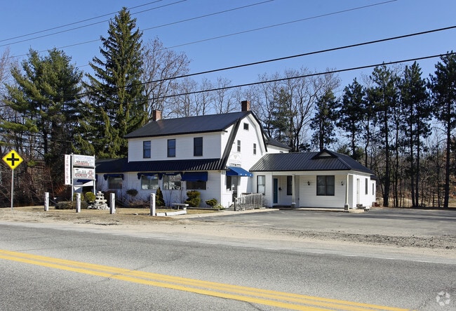
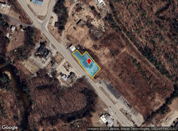
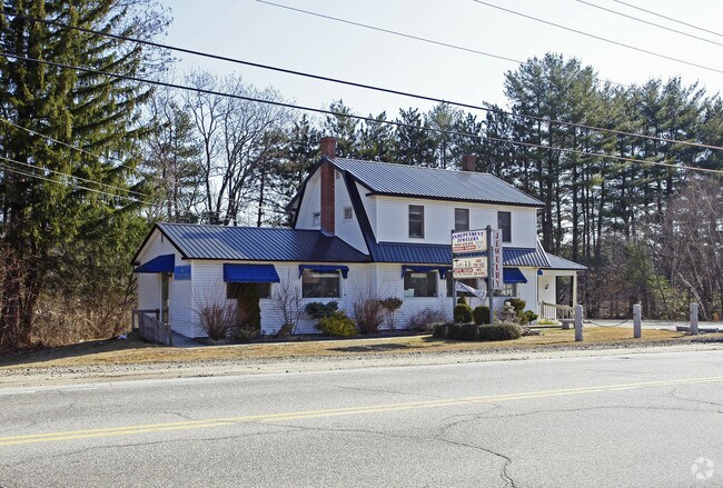
Property Record
2370 Route 16, West Ossipee, NH 03890
NEARBY LISTINGS FOR SALE OR LEASE
-
-
View all West Ossipee listings for sale on LoopNet.com
Property Detail
2370 Route 16
Commercialbuilding
Carroll
X
New Hampshire
33003C0479D
8000
2024
0.74 AC
2024
Concord/New Hampshire North Area
955601
Other Market Areas
3,917 SF
OSSI-000009-000000-008000
DEMOGRAPHICS near 2370 Route 16
1 Mile
3 Mile
5 Mile
2024 Total Population
388
1,807
5,087
2029 Population
423
1,939
5,584
Pop Growth 2024-2029
+ 9.02%
+ 7.30%
+ 9.77%
Average Age
49
49
49
2024 Total Households
183
837
2,439
HH Growth 2024-2029
+ 8.74%
+ 7.05%
+ 9.96%
Median Household Inc
$71,029
$67,258
$60,326
Avg Household Size
2.10
2.10
2.00
2024 Avg HH Vehicles
2.00
2.00
2.00
Median Home Value
$283,333
$301,117
$309,929
Median Year Built
1976
1977
1982
Nearby Places
Map Layers
Map Styles
 Street
 Aerial
- Restaurants
- Banks
- Shops
- Fitness
- Groceries
SALE & LEASE HISTORY
LISTING DATE
SALE/LEASE

May 04, 2022
For Sale
Nearby Properties
Address
Land Use
TOTAL SIZE
Lot Size
Zoning
Address
Land Use
TOTAL SIZE
Lot Size
Zoning
1,421 SF
TAMWOR
Address
Land Use
TOTAL SIZE
Lot Size
Zoning
26.90 AC
TAMWOR
Address
Land Use
TOTAL SIZE
Lot Size
Zoning
1,001 SF
25.80 AC
OSSIPE
Address
Land Use
TOTAL SIZE
Lot Size
Zoning
1,628 SF
902.70 AC
TAMWOR
Address
Land Use
TOTAL SIZE
Lot Size
Zoning
13,017 SF
116.50 AC
GENERA
Address
Land Use
TOTAL SIZE
Lot Size
Zoning
2,022 SF
51.77 AC
COMMER
Address
Land Use
TOTAL SIZE
Lot Size
Zoning
6,129 SF
29.50 AC
RUR
Address
Land Use
TOTAL SIZE
Lot Size
Zoning
3,812 SF
10.74 AC
OSSIPE
Address
Land Use
TOTAL SIZE
Lot Size
Zoning
22,103 SF
5.59 AC
COM
Address
Land Use
TOTAL SIZE
Lot Size
Zoning
19,271 SF
8 AC
RSC
Address
Land Use
TOTAL SIZE
Lot Size
Zoning
15,257 SF
3.50 AC
RSC
Address
Land Use
TOTAL SIZE
Lot Size
Zoning
11,220 SF
2.40 AC
COM
Address
Land Use
TOTAL SIZE
Lot Size
Zoning
1,298 SF
2.86 AC
TAMWOR
Address
Land Use
TOTAL SIZE
Lot Size
Zoning
1,720 SF
186.40 AC
TAMWOR
Address
Land Use
TOTAL SIZE
Lot Size
Zoning
4,340 SF
0.97 AC
OSSIPE
Address
Land Use
TOTAL SIZE
Lot Size
Zoning
38 AC
TAMWOR
Address
Land Use
TOTAL SIZE
Lot Size
Zoning
2,301 SF
3.06 AC
OSSIPE
Address
Land Use
TOTAL SIZE
Lot Size
Zoning
0.59 AC
TAMWOR
Address
Land Use
TOTAL SIZE
Lot Size
Zoning
28,588 SF
2.50 AC
TAMWOR
Address
Land Use
TOTAL SIZE
Lot Size
Zoning
5.60 AC
RSC
Address
Land Use
TOTAL SIZE
Lot Size
Zoning
3,000 SF
5.34 AC
TAMWOR
Address
Land Use
TOTAL SIZE
Lot Size
Zoning
1.50 AC
RSC
Address
Land Use
TOTAL SIZE
Lot Size
Zoning
5,089 SF
9.91 AC
TAMWOR
Address
Land Use
TOTAL SIZE
Lot Size
Zoning
927 SF
5.17 AC
TAMWOR
Address
Land Use
TOTAL SIZE
Lot Size
Zoning
6,000 SF
4 AC
TAMWOR
Address
Land Use
TOTAL SIZE
Lot Size
Zoning
3,351 SF
1.41 AC
COM
Address
Land Use
TOTAL SIZE
Lot Size
Zoning
3,962 SF
0.63 AC
RSC
Address
Land Use
TOTAL SIZE
Lot Size
Zoning
15.22 AC
RSC
Address
Land Use
TOTAL SIZE
Lot Size
Zoning
9,360 SF
1.30 AC
TAMWOR
Address
Land Use
TOTAL SIZE
Lot Size
Zoning
2,028 SF
27.70 AC
TAMWOR
The World's #1 Commercial Real Estate Marketplace
Connect with us
© 2026 CoStar Group
The information above has been obtained from sources believed reliable. While we do not doubt its accuracy we have not verified it and make no guarantee, warranty or representation about it. It is your responsibility to independently confirm its accuracy and completeness. Any projections, opinions, assumptions, or estimates used are for example only and do not represent the current or future performance of the property. The value of this transaction to you depends on tax and other factors which should be evaluated by your tax, financial, and legal advisors. You and your advisors should conduct a careful, independent investigation of the property to determine to your satisfaction the suitability of the property for your needs.