Property Record
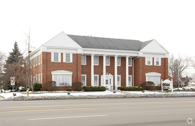
23701 Ford Rd, Dearborn, MI 48128


Property Detail
23701 Ford Rd
32-09-161-03-001
LOTS 14 TO 26 INCL TELEGRAPH FORD SUB
Funeralhome
Wayne
BB
Michigan
B and X Area of moderate flood hazard, usually the area between the limits of the 100-year and 500-year floods.
14-26
2025
0.62 AC
2025
Dearborn
574600
Detroit
12,699 SF
Detroit-Warren-Dearborn, MI
NEARBY LISTINGS FOR SALE OR LEASE
DEMOGRAPHICS near 23701 Ford Rd
1 mile
3 mile
5 mile
2025 Total Population
16,308
125,094
328,427
2030 Population
15,953
123,115
323,701
Pop Growth 2025-2030
(2.18%)
(1.58%)
(1.44%)
Average Age
38
38
38
2025 Total Households
5,652
46,347
123,217
HH Growth 2025-2030
(2.21%)
(1.58%)
(1.46%)
Median Household Inc
$85,752
$62,713
$57,375
Avg Household Size
2.80
2.60
2.60
2025 Avg HH Vehicles
2.00
2.00
2.00
Median Home Value
$258,826
$192,607
$164,170
Median Year Built
1952
1955
1955
Nearby Places
Map Layers
Map Styles
 Street
 Aerial
Layers
 Traffic
 Biking
Places
Listings with unknown addresses are not visible on the map
- Restaurants
- Banks
- Shops
- Fitness
- Groceries
PUBLIC TRANSPORTATION
COMMUTER RAIL
Dearborn (Wolverine - Amtrak)
Drive
Walk
Distance
Dearborn (Wolverine - Amtrak)
8 min
3.8 mi
AIRPORT
Detroit Metro Wayne County
Drive
Walk
Distance
Detroit Metro Wayne County
24 min
12.9 mi
Windsor International
Drive
Walk
Distance
Windsor International
42 min
22.7 mi
Freight Ports
Port of Toledo
Drive
Walk
Distance
Port of Toledo
76 min
56.1 mi
Nearby Properties
Address
Land Use
TOTAL SIZE
Lot Size
Zoning
Address
Land Use
TOTAL SIZE
Lot Size
Zoning
5,597,761 SF
73.85 AC
IB
Address
Land Use
TOTAL SIZE
Lot Size
Zoning
373,209 SF
349 AC
IC
Address
Land Use
TOTAL SIZE
Lot Size
Zoning
675,440 SF
66.32 AC
IB
Address
Land Use
TOTAL SIZE
Lot Size
Zoning
1,209,711 SF
69.44 AC
IB
Address
Land Use
TOTAL SIZE
Lot Size
Zoning
590,893 SF
51.81 AC
IB
Address
Land Use
TOTAL SIZE
Lot Size
Zoning
324,414 SF
18.68 AC
RD
Address
Land Use
TOTAL SIZE
Lot Size
Zoning
854,358 SF
12.49 AC
BC
Address
Land Use
TOTAL SIZE
Lot Size
Zoning
Address
Land Use
TOTAL SIZE
Lot Size
Zoning
349,045 SF
40.28 AC
IB
Address
Land Use
TOTAL SIZE
Lot Size
Zoning
78,450 SF
12.03 AC
BC
Address
Land Use
TOTAL SIZE
Lot Size
Zoning
335,133 SF
22.08 AC
Address
Land Use
TOTAL SIZE
Lot Size
Zoning
228,519 SF
6.16 AC
BC
Address
Land Use
TOTAL SIZE
Lot Size
Zoning
Address
Land Use
TOTAL SIZE
Lot Size
Zoning
562,922 SF
30 AC
BC
Address
Land Use
TOTAL SIZE
Lot Size
Zoning
126,712 SF
4.52 AC
BC
Address
Land Use
TOTAL SIZE
Lot Size
Zoning
810,000 SF
23.15 AC
BC
Address
Land Use
TOTAL SIZE
Lot Size
Zoning
463,642 SF
22.82 AC
Address
Land Use
TOTAL SIZE
Lot Size
Zoning
247,588 SF
4.12 AC
RE
Address
Land Use
TOTAL SIZE
Lot Size
Zoning
148,491 SF
11.34 AC
BC
Address
Land Use
TOTAL SIZE
Lot Size
Zoning
240,425 SF
6.39 AC
IB
Address
Land Use
TOTAL SIZE
Lot Size
Zoning
328,480 SF
11.54 AC
IA
Address
Land Use
TOTAL SIZE
Lot Size
Zoning
84,333 SF
1.15 AC
BC
Address
Land Use
TOTAL SIZE
Lot Size
Zoning
72,326 SF
0.74 AC
BB
Address
Land Use
TOTAL SIZE
Lot Size
Zoning
637,820 SF
10.87 AC
BC
Address
Land Use
TOTAL SIZE
Lot Size
Zoning
63,898 SF
BC
Address
Land Use
TOTAL SIZE
Lot Size
Zoning
86.77 AC
BC
Address
Land Use
TOTAL SIZE
Lot Size
Zoning
107,680 SF
7.46 AC
BC
Address
Land Use
TOTAL SIZE
Lot Size
Zoning
95,908 SF
1.12 AC
BB
Address
Land Use
TOTAL SIZE
Lot Size
Zoning
207,081 SF
8.80 AC
B5
Address
Land Use
TOTAL SIZE
Lot Size
Zoning
127,391 SF
1.79 AC
BC
The World's #1 Commercial Real Estate Marketplace
Connect with us
© 2026 CoStar Group
The information above has been obtained from sources believed reliable. While we do not doubt its accuracy we have not verified it and make no guarantee, warranty or representation about it. It is your responsibility to independently confirm its accuracy and completeness. Any projections, opinions, assumptions, or estimates used are for example only and do not represent the current or future performance of the property. The value of this transaction to you depends on tax and other factors which should be evaluated by your tax, financial, and legal advisors. You and your advisors should conduct a careful, independent investigation of the property to determine to your satisfaction the suitability of the property for your needs.