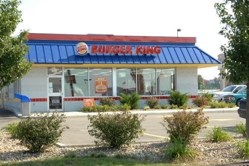
Property Record
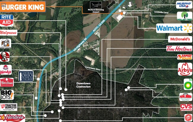
23711 Airport Rd, Coshocton, OH 43812


NEARBY LISTINGS FOR SALE OR LEASE
Property Detail
23711 Airport Rd
Coshocton, OH
Airport Canal Way Subdivision
03500-000-973-03
RTS: 06-05-01 LOT 1 1.090A (47501 SQUARE FEET) AIRPORT-CANAL WAY SUBDIVISION 08 DOC 548
Restaurantbuilding
Coshocton
X
Ohio
39031C0215C
1
2024
1.09 AC
2024
Ohio North Area
961300
Other Market Areas
2,994 SF
DEMOGRAPHICS near 23711 Airport Rd
1 Mile
3 Mile
5 Mile
2024 Total Population
430
13,259
17,985
2029 Population
430
13,293
18,016
Pop Growth 2024-2029
0.00%
+ 0.26%
+ 0.17%
Average Age
44
41
42
2024 Total Households
181
5,674
7,549
HH Growth 2024-2029
0.00%
+ 0.28%
+ 0.20%
Median Household Inc
$52,666
$42,099
$44,653
Avg Household Size
2.40
2.30
2.30
2024 Avg HH Vehicles
2.00
2.00
2.00
Median Home Value
$126,190
$90,660
$109,024
Median Year Built
1976
1954
1959
Nearby Places
Map Layers
Map Styles
 Street
 Aerial
- Restaurants
- Banks
- Shops
- Fitness
- Groceries
SALE & LEASE HISTORY
LISTING DATE
SALE/LEASE

Sep 25, 2017
For Sale
Sep 24, 2016
For Sale
Sep 24, 2016
For Sale
Sep 20, 2018
For Sale
Dec 16, 2020
For Sale
Nearby Properties
Address
Land Use
TOTAL SIZE
Lot Size
Zoning
Address
Land Use
TOTAL SIZE
Lot Size
Zoning
792 SF
26.21 AC
Address
Land Use
TOTAL SIZE
Lot Size
Zoning
3.25 AC
Address
Land Use
TOTAL SIZE
Lot Size
Zoning
1.21 AC
Address
Land Use
TOTAL SIZE
Lot Size
Zoning
183,906 SF
31.16 AC
Address
Land Use
TOTAL SIZE
Lot Size
Zoning
11,200 SF
20.80 AC
Address
Land Use
TOTAL SIZE
Lot Size
Zoning
20,990 SF
1.61 AC
Address
Land Use
TOTAL SIZE
Lot Size
Zoning
38.53 AC
Address
Land Use
TOTAL SIZE
Lot Size
Zoning
4,014 SF
34.92 AC
Address
Land Use
TOTAL SIZE
Lot Size
Zoning
48,185 SF
1.36 AC
Address
Land Use
TOTAL SIZE
Lot Size
Zoning
2,693 SF
37.51 AC
Address
Land Use
TOTAL SIZE
Lot Size
Zoning
37.85 AC
Address
Land Use
TOTAL SIZE
Lot Size
Zoning
32,896 SF
0.15 AC
Address
Land Use
TOTAL SIZE
Lot Size
Zoning
52,736 SF
17.14 AC
Address
Land Use
TOTAL SIZE
Lot Size
Zoning
74,740 SF
0.11 AC
Address
Land Use
TOTAL SIZE
Lot Size
Zoning
7,684 SF
2.76 AC
Address
Land Use
TOTAL SIZE
Lot Size
Zoning
Address
Land Use
TOTAL SIZE
Lot Size
Zoning
2,940 SF
3.56 AC
Address
Land Use
TOTAL SIZE
Lot Size
Zoning
7,872 SF
0.27 AC
Address
Land Use
TOTAL SIZE
Lot Size
Zoning
162,786 SF
9.17 AC
Address
Land Use
TOTAL SIZE
Lot Size
Zoning
33,952 SF
7.63 AC
Address
Land Use
TOTAL SIZE
Lot Size
Zoning
35,704 SF
45.78 AC
Address
Land Use
TOTAL SIZE
Lot Size
Zoning
422.83 AC
Address
Land Use
TOTAL SIZE
Lot Size
Zoning
0.72 AC
Address
Land Use
TOTAL SIZE
Lot Size
Zoning
28,648 SF
2.96 AC
Address
Land Use
TOTAL SIZE
Lot Size
Zoning
20,462 SF
2.01 AC
Address
Land Use
TOTAL SIZE
Lot Size
Zoning
1,104 SF
201.76 AC
Address
Land Use
TOTAL SIZE
Lot Size
Zoning
25,353 SF
20.08 AC
Address
Land Use
TOTAL SIZE
Lot Size
Zoning
82,214 SF
8.78 AC
Address
Land Use
TOTAL SIZE
Lot Size
Zoning
40,282 SF
1.32 AC
Address
Land Use
TOTAL SIZE
Lot Size
Zoning
239.55 AC
The World's #1 Commercial Real Estate Marketplace
Connect with us
© 2025 CoStar Group
The information above has been obtained from sources believed reliable. While we do not doubt its accuracy we have not verified it and make no guarantee, warranty or representation about it. It is your responsibility to independently confirm its accuracy and completeness. Any projections, opinions, assumptions, or estimates used are for example only and do not represent the current or future performance of the property. The value of this transaction to you depends on tax and other factors which should be evaluated by your tax, financial, and legal advisors. You and your advisors should conduct a careful, independent investigation of the property to determine to your satisfaction the suitability of the property for your needs.