Property Record
2375 Pocahontas Trl, Quinton, VA 23141
NEARBY LISTINGS FOR SALE OR LEASE
-
-
View all Quinton listings for sale on LoopNet.com
Property Detail
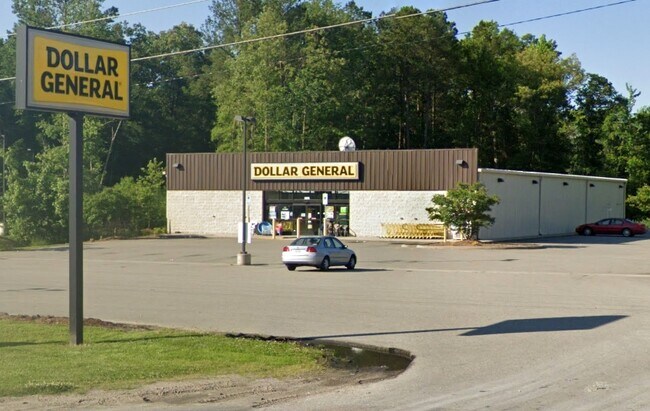
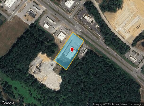
2375 Pocahontas Trl
Richmond, VA
Quinton Place
19 44C2
QUINTON PLACE PB 21/95 2.076 AC DB 571/1108
Commercialnec
New Kent
A
Virginia
51085C0465C
44
0
2.08 AC
2025
New Kent County
700100
Richmond VA
9,100 SF
DEMOGRAPHICS near 2375 Pocahontas Trl
1 Mile
3 Mile
5 Mile
2024 Total Population
1,825
9,086
15,811
2029 Population
2,217
10,411
17,935
Pop Growth 2024-2029
+ 21.48%
+ 14.58%
+ 13.43%
Average Age
43
44
44
2024 Total Households
681
3,568
6,229
HH Growth 2024-2029
+ 21.59%
+ 14.15%
+ 13.13%
Median Household Inc
$132,936
$98,960
$92,469
Avg Household Size
2.60
2.50
2.50
2024 Avg HH Vehicles
3.00
3.00
3.00
Median Home Value
$347,073
$316,299
$306,095
Median Year Built
1995
1988
1987
Nearby Places
- Restaurants
- Banks
- Shops
- Fitness
- Groceries
PUBLIC TRANSPORTATION
AIRPORT
Richmond International
DRIVE
WALK
Distance
Richmond International
15 min
8.2 mi
Freight Ports
Virginia Port Authority - Richmond
DRIVE
WALK
Distance
Virginia Port Authority - Richmond
29 min
18.9 mi
Nearby Properties
Address
Land Use
TOTAL SIZE
Lot Size
Zoning
Address
Land Use
TOTAL SIZE
Lot Size
Zoning
976,550 SF
129.27 AC
M-2
Address
Land Use
TOTAL SIZE
Lot Size
Zoning
382,408 SF
65 AC
M-2
Address
Land Use
TOTAL SIZE
Lot Size
Zoning
339,884 SF
22.48 AC
M-2
Address
Land Use
TOTAL SIZE
Lot Size
Zoning
995,854 SF
97.55 AC
M-2
Address
Land Use
TOTAL SIZE
Lot Size
Zoning
257,938 SF
93.42 AC
M-2
Address
Land Use
TOTAL SIZE
Lot Size
Zoning
95,597 SF
15.56 AC
R1
Address
Land Use
TOTAL SIZE
Lot Size
Zoning
345,600 SF
64.05 AC
M-2
Address
Land Use
TOTAL SIZE
Lot Size
Zoning
17,260 SF
17.32 AC
BUS
Address
Land Use
TOTAL SIZE
Lot Size
Zoning
117,522 SF
67.74 AC
A-1
Address
Land Use
TOTAL SIZE
Lot Size
Zoning
54,328 SF
22.75 AC
M-2
Address
Land Use
TOTAL SIZE
Lot Size
Zoning
50,854 SF
38.96 AC
MIXE
Address
Land Use
TOTAL SIZE
Lot Size
Zoning
49,702 SF
6.04 AC
BUS
Address
Land Use
TOTAL SIZE
Lot Size
Zoning
52,950 SF
8.52 AC
BUS
Address
Land Use
TOTAL SIZE
Lot Size
Zoning
19,041 SF
3.97 AC
PUD
Address
Land Use
TOTAL SIZE
Lot Size
Zoning
18.25 AC
PUD
Address
Land Use
TOTAL SIZE
Lot Size
Zoning
2,583 SF
532.40 AC
EO
Address
Land Use
TOTAL SIZE
Lot Size
Zoning
14,731 SF
1.75 AC
BUS
Address
Land Use
TOTAL SIZE
Lot Size
Zoning
14,576 SF
6 AC
BUS
Address
Land Use
TOTAL SIZE
Lot Size
Zoning
21,702 SF
1.08 AC
PUD
Address
Land Use
TOTAL SIZE
Lot Size
Zoning
3,470 SF
2.29 AC
EO
Address
Land Use
TOTAL SIZE
Lot Size
Zoning
4,288 SF
2.97 AC
EO
Address
Land Use
TOTAL SIZE
Lot Size
Zoning
4,980 SF
18.73 AC
BUS
Address
Land Use
TOTAL SIZE
Lot Size
Zoning
45.69 AC
BUS
Address
Land Use
TOTAL SIZE
Lot Size
Zoning
3,240 SF
12 AC
A1
Address
Land Use
TOTAL SIZE
Lot Size
Zoning
12,000 SF
1.17 AC
PUD
Address
Land Use
TOTAL SIZE
Lot Size
Zoning
2,384 SF
3.77 AC
BUS
Address
Land Use
TOTAL SIZE
Lot Size
Zoning
27,008 SF
7.05 AC
R1
Address
Land Use
TOTAL SIZE
Lot Size
Zoning
13,108 SF
6.14 AC
R1
Address
Land Use
TOTAL SIZE
Lot Size
Zoning
64.44 AC
EO
Address
Land Use
TOTAL SIZE
Lot Size
Zoning
7,056 SF
1.98 AC
BUS
The World's #1 Commercial Real Estate Marketplace
Connect with us
© 2025 CoStar Group
The information above has been obtained from sources believed reliable. While we do not doubt its accuracy we have not verified it and make no guarantee, warranty or representation about it. It is your responsibility to independently confirm its accuracy and completeness. Any projections, opinions, assumptions, or estimates used are for example only and do not represent the current or future performance of the property. The value of this transaction to you depends on tax and other factors which should be evaluated by your tax, financial, and legal advisors. You and your advisors should conduct a careful, independent investigation of the property to determine to your satisfaction the suitability of the property for your needs.