Property Record
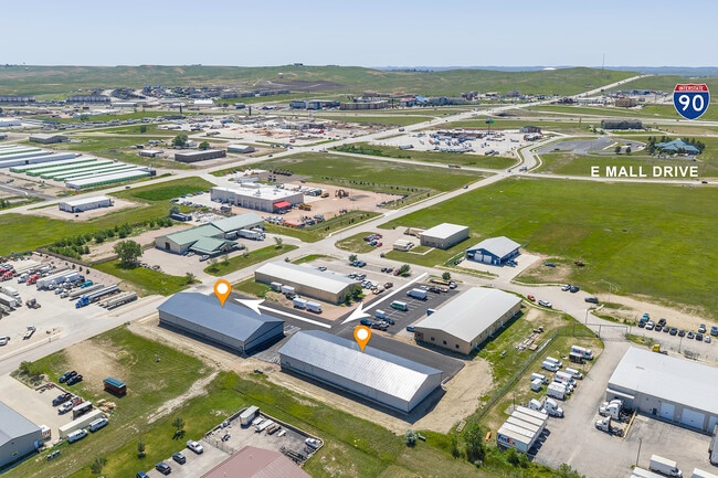
3612 Galt Ct, Rapid City, SD 57701

Property Detail
3612 Galt Ct
Rapid City, SD
I-90 HEARTLAND BUSINESS PARK, BLOCK 3, LOT 5A-R
0064339
Pennington
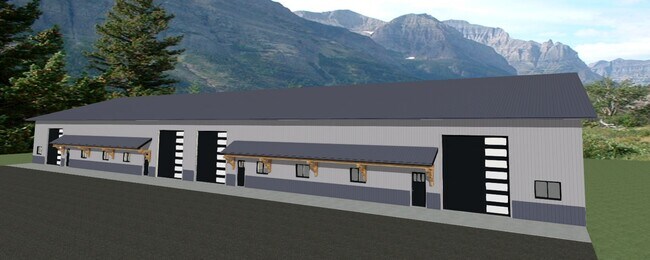
Loftbuilding
South Dakota
B and X Area of moderate flood hazard, usually the area between the limits of the 100-year and 500-year floods.
5a
2025
2.64 AC
2025
Rapid City
011400
Other Market Areas
11,200 SF
NEARBY LISTINGS FOR SALE OR LEASE
DEMOGRAPHICS near 3612 Galt Ct
1 mile
3 mile
5 mile
2025 Total Population
623
18,489
66,498
2030 Population
664
19,458
69,607
Pop Growth 2025-2030
+ 6.58%
+ 5.24%
+ 4.68%
Average Age
36
39
39
2025 Total Households
237
7,382
26,764
HH Growth 2025-2030
+ 6.75%
+ 5.26%
+ 4.95%
Median Household Inc
$83,456
$71,393
$66,288
Avg Household Size
2.60
2.40
2.30
2025 Avg HH Vehicles
2.00
2.00
2.00
Median Home Value
$335,795
$258,673
$267,613
Median Year Built
2010
1993
1986
Nearby Places
Map Layers
Map Styles
 Street
 Aerial
Transit
 Traffic
 Biking
Places
Listings with unknown addresses are not visible on the map
- Restaurants
- Banks
- Shops
- Fitness
- Groceries
PUBLIC TRANSPORTATION
AIRPORT
Rapid City Regional
Drive
Walk
Distance
Rapid City Regional
25 min
11.8 mi
SALE & LEASE HISTORY
LISTING DATE
SALE/LEASE

Aug 19, 2024
For Lease
Nearby Properties
Address
Land Use
TOTAL SIZE
Lot Size
Zoning
Address
Land Use
TOTAL SIZE
Lot Size
Zoning
19,781 SF
11.03 AC
Address
Land Use
TOTAL SIZE
Lot Size
Zoning
6,480 SF
11.58 AC
Address
Land Use
TOTAL SIZE
Lot Size
Zoning
5,448 SF
8 AC
Address
Land Use
TOTAL SIZE
Lot Size
Zoning
2,632 SF
8.11 AC
Address
Land Use
TOTAL SIZE
Lot Size
Zoning
14,484 SF
5.20 AC
Address
Land Use
TOTAL SIZE
Lot Size
Zoning
55,442 SF
23.96 AC
Address
Land Use
TOTAL SIZE
Lot Size
Zoning
4,005 SF
12.09 AC
Address
Land Use
TOTAL SIZE
Lot Size
Zoning
38,030 SF
13.47 AC
Address
Land Use
TOTAL SIZE
Lot Size
Zoning
188,360 SF
37.53 AC
Address
Land Use
TOTAL SIZE
Lot Size
Zoning
2,018 SF
5.66 AC
Address
Land Use
TOTAL SIZE
Lot Size
Zoning
46,644 SF
11.89 AC
Address
Land Use
TOTAL SIZE
Lot Size
Zoning
2,865 SF
7.08 AC
Address
Land Use
TOTAL SIZE
Lot Size
Zoning
28,584 SF
5.62 AC
Address
Land Use
TOTAL SIZE
Lot Size
Zoning
62,209 SF
14.15 AC
Address
Land Use
TOTAL SIZE
Lot Size
Zoning
28,894 SF
2.17 AC
Address
Land Use
TOTAL SIZE
Lot Size
Zoning
29,196 SF
3.89 AC
Address
Land Use
TOTAL SIZE
Lot Size
Zoning
147,325 SF
11.93 AC
Address
Land Use
TOTAL SIZE
Lot Size
Zoning
162,960 SF
22.56 AC
Address
Land Use
TOTAL SIZE
Lot Size
Zoning
227,112 SF
21.01 AC
Address
Land Use
TOTAL SIZE
Lot Size
Zoning
45,485 SF
9.84 AC
Address
Land Use
TOTAL SIZE
Lot Size
Zoning
118,800 SF
40.85 AC
Address
Land Use
TOTAL SIZE
Lot Size
Zoning
21,735 SF
11.60 AC
Address
Land Use
TOTAL SIZE
Lot Size
Zoning
2,018 SF
3.73 AC
Address
Land Use
TOTAL SIZE
Lot Size
Zoning
24,297 SF
5.15 AC
Address
Land Use
TOTAL SIZE
Lot Size
Zoning
65,922 SF
6 AC
Address
Land Use
TOTAL SIZE
Lot Size
Zoning
20,988 SF
4.13 AC
Address
Land Use
TOTAL SIZE
Lot Size
Zoning
55,000 SF
10.62 AC
Address
Land Use
TOTAL SIZE
Lot Size
Zoning
132,130 SF
11.54 AC
Address
Land Use
TOTAL SIZE
Lot Size
Zoning
140,629 SF
14.59 AC
Address
Land Use
TOTAL SIZE
Lot Size
Zoning
95,992 SF
56.73 AC
The World's #1 Commercial Real Estate Marketplace
Connect with us
© 2026 CoStar Group
The information above has been obtained from sources believed reliable. While we do not doubt its accuracy we have not verified it and make no guarantee, warranty or representation about it. It is your responsibility to independently confirm its accuracy and completeness. Any projections, opinions, assumptions, or estimates used are for example only and do not represent the current or future performance of the property. The value of this transaction to you depends on tax and other factors which should be evaluated by your tax, financial, and legal advisors. You and your advisors should conduct a careful, independent investigation of the property to determine to your satisfaction the suitability of the property for your needs.