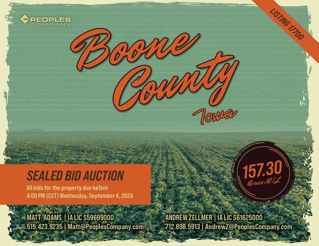
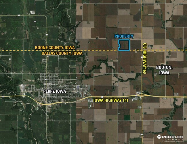
Property Record
2378 G Ave, Perry, IA 50220
NEARBY LISTINGS FOR SALE OR LEASE
-
-
View all Perry listings for sale on LoopNet.com
Property Detail
2378 G Ave
088227313300002
W 35.50 A OF NE SW
Agriculturalland
Boone
X
Iowa
19015C0425D
41.27 AC
2025
Fort Dodge/Ames
2025
Other Market Areas
050400
Ames, IA
DEMOGRAPHICS near 2378 G Ave
1 Mile
3 Mile
5 Mile
2024 Total Population
21
3,073
9,696
2029 Population
21
3,586
11,390
Pop Growth 2024-2029
0.00%
+ 16.69%
+ 17.47%
Average Age
41
40
39
2024 Total Households
7
1,160
3,623
HH Growth 2024-2029
0.00%
+ 17.76%
+ 18.44%
Median Household Inc
$99,999
$55,076
$48,041
Avg Household Size
2.10
2.50
2.60
2024 Avg HH Vehicles
3.00
2.00
2.00
Median Home Value
$299,999
$150,913
$134,575
Median Year Built
1959
1964
1954
Nearby Places
Map Layers
Map Styles
 Street
 Aerial
- Restaurants
- Banks
- Shops
- Fitness
- Groceries
SALE & LEASE HISTORY
LISTING DATE
SALE/LEASE

Aug 15, 2024
For Sale
Nearby Properties
Address
Land Use
TOTAL SIZE
Lot Size
Zoning
Address
Land Use
TOTAL SIZE
Lot Size
Zoning
16 AC
Address
Land Use
TOTAL SIZE
Lot Size
Zoning
30,672 SF
4.01 AC
Address
Land Use
TOTAL SIZE
Lot Size
Zoning
8,560 SF
1.07 AC
Address
Land Use
TOTAL SIZE
Lot Size
Zoning
40,532 SF
16.27 AC
Address
Land Use
TOTAL SIZE
Lot Size
Zoning
8,000 SF
14.76 AC
Address
Land Use
TOTAL SIZE
Lot Size
Zoning
2,400 SF
5.55 AC
Address
Land Use
TOTAL SIZE
Lot Size
Zoning
42,600 SF
5.20 AC
Address
Land Use
TOTAL SIZE
Lot Size
Zoning
10,877 SF
4.25 AC
Address
Land Use
TOTAL SIZE
Lot Size
Zoning
1,600 SF
5 AC
Address
Land Use
TOTAL SIZE
Lot Size
Zoning
12,982 SF
4.37 AC
Address
Land Use
TOTAL SIZE
Lot Size
Zoning
31,065 SF
5.50 AC
Address
Land Use
TOTAL SIZE
Lot Size
Zoning
3.33 AC
Address
Land Use
TOTAL SIZE
Lot Size
Zoning
1,155 SF
4.95 AC
Address
Land Use
TOTAL SIZE
Lot Size
Zoning
1,534 SF
3.75 AC
Address
Land Use
TOTAL SIZE
Lot Size
Zoning
5,933 SF
2.71 AC
Address
Land Use
TOTAL SIZE
Lot Size
Zoning
3,480 SF
2.16 AC
Address
Land Use
TOTAL SIZE
Lot Size
Zoning
2,394 SF
2.53 AC
Address
Land Use
TOTAL SIZE
Lot Size
Zoning
2,408 SF
3.06 AC
Address
Land Use
TOTAL SIZE
Lot Size
Zoning
1,325 SF
2.02 AC
Address
Land Use
TOTAL SIZE
Lot Size
Zoning
30,000 SF
5.26 AC
Address
Land Use
TOTAL SIZE
Lot Size
Zoning
15,967 SF
4.38 AC
Address
Land Use
TOTAL SIZE
Lot Size
Zoning
2,100 SF
48.03 AC
Address
Land Use
TOTAL SIZE
Lot Size
Zoning
7,128 SF
0.99 AC
Address
Land Use
TOTAL SIZE
Lot Size
Zoning
4,032 SF
3.22 AC
Address
Land Use
TOTAL SIZE
Lot Size
Zoning
11,232 SF
0.58 AC
Address
Land Use
TOTAL SIZE
Lot Size
Zoning
11,080 SF
1.50 AC
Address
Land Use
TOTAL SIZE
Lot Size
Zoning
7,311 SF
0.91 AC
Address
Land Use
TOTAL SIZE
Lot Size
Zoning
22,718 SF
0.96 AC
Address
Land Use
TOTAL SIZE
Lot Size
Zoning
2,856 SF
5 AC
The World's #1 Commercial Real Estate Marketplace
Connect with us
© 2026 CoStar Group
The information above has been obtained from sources believed reliable. While we do not doubt its accuracy we have not verified it and make no guarantee, warranty or representation about it. It is your responsibility to independently confirm its accuracy and completeness. Any projections, opinions, assumptions, or estimates used are for example only and do not represent the current or future performance of the property. The value of this transaction to you depends on tax and other factors which should be evaluated by your tax, financial, and legal advisors. You and your advisors should conduct a careful, independent investigation of the property to determine to your satisfaction the suitability of the property for your needs.