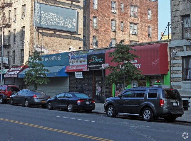
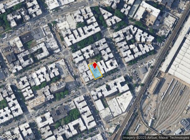
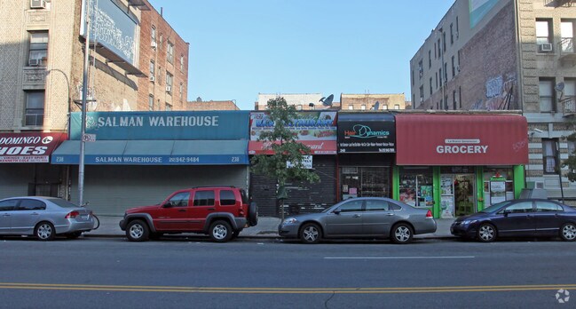
Property Record
238 Sherman Ave, New York, NY 10034

Current Lease Availabilities
NEARBY LISTINGS FOR SALE OR LEASE
Property Detail
238 Sherman Ave
2227-0026
Manhattan
Storebuilding
New York
X
26
3604970081F
0.26 AC
2024
Harlem/North Manhattan
2025
New York City
029300
New York-Jersey City-White Plains, NY-NJ
9,000 SF
DEMOGRAPHICS near 238 Sherman Ave
1 Mile
3 Mile
5 Mile
2024 Total Population
141,956
979,326
2,004,356
2029 Population
132,372
919,658
1,871,796
Pop Growth 2024-2029
(6.75%)
(6.09%)
(6.61%)
Average Age
40
38
39
2024 Total Households
53,420
356,216
737,696
HH Growth 2024-2029
(7.14%)
(6.60%)
(7.06%)
Median Household Inc
$49,179
$44,383
$47,717
Avg Household Size
2.50
2.60
2.60
2024 Avg HH Vehicles
.00
.00
1.00
Median Home Value
$371,727
$450,497
$530,938
Median Year Built
1948
1949
1952
Nearby Places
- Restaurants
- Banks
- Shops
- Fitness
- Groceries
PUBLIC TRANSPORTATION
TRANSIT/SUBWAY
207 Street (1 - New York MTA Subway (The Subway))
DRIVE
WALK
Distance
207 Street (1 - New York MTA Subway (The Subway))
0 min
3 min
0.1 mi
Inwood-207 Street (A - New York MTA Subway (The Subway))
DRIVE
WALK
Distance
Inwood-207 Street (A - New York MTA Subway (The Subway))
0 min
3 min
0.2 mi
215 Street (1 - New York MTA Subway (The Subway))
DRIVE
WALK
Distance
215 Street (1 - New York MTA Subway (The Subway))
1 min
7 min
0.3 mi
Dyckman Street (A Line) (A - New York MTA Subway (The Subway))
DRIVE
WALK
Distance
Dyckman Street (A Line) (A - New York MTA Subway (The Subway))
1 min
10 min
0.5 mi
University Heights Station (Hudson Line - Metro-North Commuter Railroad Company (Metro-North))
DRIVE
WALK
Distance
University Heights Station (Hudson Line - Metro-North Commuter Railroad Company (Metro-North))
3 min
11 min
0.6 mi
COMMUTER RAIL
University Heights Station (Hudson Line - Metro-North Commuter Railroad Company (Metro-North))
DRIVE
WALK
Distance
University Heights Station (Hudson Line - Metro-North Commuter Railroad Company (Metro-North))
2 min
11 min
0.6 mi
Marble Hill Station (Hudson Line - Metro-North Commuter Railroad Company (Metro-North))
DRIVE
WALK
Distance
Marble Hill Station (Hudson Line - Metro-North Commuter Railroad Company (Metro-North))
5 min
16 min
0.9 mi
AIRPORT
LaGuardia
DRIVE
WALK
Distance
LaGuardia
20 min
10.6 mi
John F Kennedy International
DRIVE
WALK
Distance
John F Kennedy International
35 min
21.8 mi
Westchester County
DRIVE
WALK
Distance
Westchester County
36 min
23.3 mi
Freight Ports
NY - Red Hook Container Terminal
DRIVE
WALK
Distance
NY - Red Hook Container Terminal
33 min
16.3 mi
Nearby Properties
Address
Land Use
TOTAL SIZE
Lot Size
Zoning
Address
Land Use
TOTAL SIZE
Lot Size
Zoning
3,693,539 SF
8.37 AC
R8
Address
Land Use
TOTAL SIZE
Lot Size
Zoning
1,299,700 SF
29.82 AC
R6
Address
Land Use
TOTAL SIZE
Lot Size
Zoning
1,743,584 SF
77.87 AC
R6
Address
Land Use
TOTAL SIZE
Lot Size
Zoning
111.37 AC
P1
Address
Land Use
TOTAL SIZE
Lot Size
Zoning
24.08 AC
B2-A
Address
Land Use
TOTAL SIZE
Lot Size
Zoning
4.87 AC
R11
Address
Land Use
TOTAL SIZE
Lot Size
Zoning
1,651,267 SF
1.23 AC
R8
Address
Land Use
TOTAL SIZE
Lot Size
Zoning
Address
Land Use
TOTAL SIZE
Lot Size
Zoning
72 AC
P1
Address
Land Use
TOTAL SIZE
Lot Size
Zoning
2.61 AC
D5
Address
Land Use
TOTAL SIZE
Lot Size
Zoning
481,172 SF
205.58 AC
PARK
Address
Land Use
TOTAL SIZE
Lot Size
Zoning
895,256 SF
8.32 AC
R7-1
Address
Land Use
TOTAL SIZE
Lot Size
Zoning
0.36 AC
R8
Address
Land Use
TOTAL SIZE
Lot Size
Zoning
891,040 SF
5.63 AC
R8
Address
Land Use
TOTAL SIZE
Lot Size
Zoning
23.12 AC
PARK
Address
Land Use
TOTAL SIZE
Lot Size
Zoning
1,237,424 SF
21.25 AC
R6
Address
Land Use
TOTAL SIZE
Lot Size
Zoning
204,200 SF
1.68 AC
R7-1
Address
Land Use
TOTAL SIZE
Lot Size
Zoning
42.68 AC
P1
Address
Land Use
TOTAL SIZE
Lot Size
Zoning
13.09 AC
C3
Address
Land Use
TOTAL SIZE
Lot Size
Zoning
100,151 SF
22.13 AC
B2
Address
Land Use
TOTAL SIZE
Lot Size
Zoning
2.55 AC
D5
Address
Land Use
TOTAL SIZE
Lot Size
Zoning
807,327 SF
0.60 AC
R8
Address
Land Use
TOTAL SIZE
Lot Size
Zoning
39 AC
P1
Address
Land Use
TOTAL SIZE
Lot Size
Zoning
5.87 AC
R10
Address
Land Use
TOTAL SIZE
Lot Size
Zoning
2,531,670 SF
17.15 AC
R7-2
Address
Land Use
TOTAL SIZE
Lot Size
Zoning
390,750 SF
265 AC
PARK
Address
Land Use
TOTAL SIZE
Lot Size
Zoning
317,485 SF
1.57 AC
R8
Address
Land Use
TOTAL SIZE
Lot Size
Zoning
43.65 AC
PARK
Address
Land Use
TOTAL SIZE
Lot Size
Zoning
631,237 SF
30.93 AC
R5
Address
Land Use
TOTAL SIZE
Lot Size
Zoning
707,353 SF
29.34 AC
R6
The World's #1 Commercial Real Estate Marketplace
Connect with us
© 2025 CoStar Group
The information above has been obtained from sources believed reliable. While we do not doubt its accuracy we have not verified it and make no guarantee, warranty or representation about it. It is your responsibility to independently confirm its accuracy and completeness. Any projections, opinions, assumptions, or estimates used are for example only and do not represent the current or future performance of the property. The value of this transaction to you depends on tax and other factors which should be evaluated by your tax, financial, and legal advisors. You and your advisors should conduct a careful, independent investigation of the property to determine to your satisfaction the suitability of the property for your needs.