Property Record
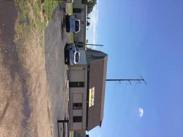
2380 Fritch Hwy, Amarillo, TX 79108


Property Detail
2380 Fritch Hwy
R-018-0600-9040-0
EASTRIDGE ADDN # 28, LOT 001, BLK 0062
Restaurantbuilding
Potter
I1
Texas
B and X Area of moderate flood hazard, usually the area between the limits of the 100-year and 500-year floods.
001
2024
0.34 AC
2025
Amarillo
012600
Other Market Areas
1,364 SF
Amarillo, TX
NEARBY LISTINGS FOR SALE OR LEASE
DEMOGRAPHICS near 2380 Fritch Hwy
1 mile
3 mile
5 mile
2024 Total Population
5,267
32,253
66,142
2029 Population
5,115
31,767
65,695
Pop Growth 2024-2029
(2.89%)
(1.51%)
(0.68%)
Average Age
34
36
37
2024 Total Households
1,547
9,234
21,395
HH Growth 2024-2029
(2.97%)
(1.71%)
(0.70%)
Median Household Inc
$48,249
$42,719
$45,222
Avg Household Size
3.30
3.00
2.80
2024 Avg HH Vehicles
2.00
2.00
2.00
Median Home Value
$113,873
$93,094
$117,481
Median Year Built
1962
1960
1961
Nearby Places
Map Layers
Map Styles
 Street
 Aerial
Transit
 Traffic
 Biking
Places
Listings with unknown addresses are not visible on the map
- Restaurants
- Banks
- Shops
- Fitness
- Groceries
PUBLIC TRANSPORTATION
AIRPORT
Rick Husband Amarillo International
Drive
Walk
Distance
Rick Husband Amarillo International
14 min
7.6 mi
SALE & LEASE HISTORY
LISTING DATE
SALE/LEASE

Aug 22, 2017
For Sale
Nearby Properties
Address
Land Use
TOTAL SIZE
Lot Size
Zoning
Address
Land Use
TOTAL SIZE
Lot Size
Zoning
1,079,953 SF
106.07 AC
Address
Land Use
TOTAL SIZE
Lot Size
Zoning
414,471 SF
104.16 AC
LC
Address
Land Use
TOTAL SIZE
Lot Size
Zoning
265,956 SF
48 AC
Address
Land Use
TOTAL SIZE
Lot Size
Zoning
91,802 SF
7 AC
Address
Land Use
TOTAL SIZE
Lot Size
Zoning
315,634 SF
53.49 AC
Address
Land Use
TOTAL SIZE
Lot Size
Zoning
76,777 SF
17.10 AC
Address
Land Use
TOTAL SIZE
Lot Size
Zoning
132,820 SF
15.85 AC
R2
Address
Land Use
TOTAL SIZE
Lot Size
Zoning
64,847 SF
25.67 AC
R1
Address
Land Use
TOTAL SIZE
Lot Size
Zoning
39,430 SF
38.42 AC
Address
Land Use
TOTAL SIZE
Lot Size
Zoning
92,341 SF
9.91 AC
R3
Address
Land Use
TOTAL SIZE
Lot Size
Zoning
23.39 AC
Address
Land Use
TOTAL SIZE
Lot Size
Zoning
74,509 SF
2.49 AC
Address
Land Use
TOTAL SIZE
Lot Size
Zoning
37,134 SF
3.26 AC
Address
Land Use
TOTAL SIZE
Lot Size
Zoning
76,559 SF
3.87 AC
LC
Address
Land Use
TOTAL SIZE
Lot Size
Zoning
71,907 SF
8.54 AC
2F
Address
Land Use
TOTAL SIZE
Lot Size
Zoning
73,258 SF
7.58 AC
R2
Address
Land Use
TOTAL SIZE
Lot Size
Zoning
79,521 SF
Address
Land Use
TOTAL SIZE
Lot Size
Zoning
89,982 SF
9.75 AC
Address
Land Use
TOTAL SIZE
Lot Size
Zoning
58,977 SF
25.27 AC
PD
Address
Land Use
TOTAL SIZE
Lot Size
Zoning
65,730 SF
9.09 AC
A
Address
Land Use
TOTAL SIZE
Lot Size
Zoning
64,496 SF
8.85 AC
Address
Land Use
TOTAL SIZE
Lot Size
Zoning
201,990 SF
23.17 AC
MF1
Address
Land Use
TOTAL SIZE
Lot Size
Zoning
93,840 SF
4.82 AC
Address
Land Use
TOTAL SIZE
Lot Size
Zoning
57,981 SF
9.55 AC
R3
Address
Land Use
TOTAL SIZE
Lot Size
Zoning
122,298 SF
8 AC
MF1
Address
Land Use
TOTAL SIZE
Lot Size
Zoning
63,497 SF
49.20 AC
I1
Address
Land Use
TOTAL SIZE
Lot Size
Zoning
41,335 SF
3.13 AC
LC
Address
Land Use
TOTAL SIZE
Lot Size
Zoning
86,885 SF
4.72 AC
LC
Address
Land Use
TOTAL SIZE
Lot Size
Zoning
127,830 SF
14.58 AC
I2
Address
Land Use
TOTAL SIZE
Lot Size
Zoning
69,362 SF
6.77 AC
HC
The World's #1 Commercial Real Estate Marketplace
Connect with us
© 2026 CoStar Group
The information above has been obtained from sources believed reliable. While we do not doubt its accuracy we have not verified it and make no guarantee, warranty or representation about it. It is your responsibility to independently confirm its accuracy and completeness. Any projections, opinions, assumptions, or estimates used are for example only and do not represent the current or future performance of the property. The value of this transaction to you depends on tax and other factors which should be evaluated by your tax, financial, and legal advisors. You and your advisors should conduct a careful, independent investigation of the property to determine to your satisfaction the suitability of the property for your needs.