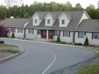
Property Record
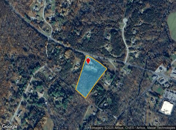
2380 Route 55, Hopewell Junction, NY 12533
NEARBY LISTINGS FOR SALE OR LEASE
Property Detail
2380 Route 55
Dutchess County-Putnam County, NY
Kemp-Scott-Monek
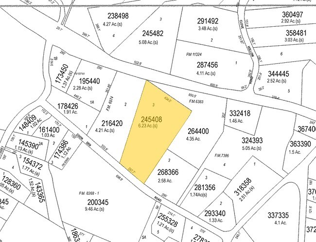
132200-6759-00-245408-0000
6.23 AC (S) 1646 0522 1640 0200
Commercialbuilding
Dutchess
X
New York
36027C0414E
245
2025
6.23 AC
2024
Fishkill
020003
Westchester/So Connecticut
5,414 SF
DEMOGRAPHICS near 2380 Route 55
1 Mile
3 Mile
5 Mile
2024 Total Population
1,617
12,591
27,784
2029 Population
1,600
12,576
27,705
Pop Growth 2024-2029
(1.05%)
(0.12%)
(0.28%)
Average Age
42
42
42
2024 Total Households
591
4,505
9,048
HH Growth 2024-2029
(1.02%)
(0.16%)
(0.32%)
Median Household Inc
$132,934
$111,169
$116,793
Avg Household Size
2.70
2.70
2.80
2024 Avg HH Vehicles
2.00
2.00
2.00
Median Home Value
$426,506
$404,948
$423,624
Median Year Built
1993
1983
1982
Nearby Places
- Restaurants
- Banks
- Shops
- Fitness
- Groceries
PUBLIC TRANSPORTATION
COMMUTER RAIL
Pawling Station (Harlem Line - Metro-North Commuter Railroad Company (Metro-North))
DRIVE
WALK
Distance
Pawling Station (Harlem Line - Metro-North Commuter Railroad Company (Metro-North))
17 min
9.6 mi
AIRPORT
New York Stewart International
DRIVE
WALK
Distance
New York Stewart International
46 min
30.0 mi
Freight Ports
Port of New Haven
DRIVE
WALK
Distance
Port of New Haven
94 min
60.8 mi
Nearby Properties
Address
Land Use
TOTAL SIZE
Lot Size
Zoning
Address
Land Use
TOTAL SIZE
Lot Size
Zoning
100 SF
86.38 AC
TC
Address
Land Use
TOTAL SIZE
Lot Size
Zoning
13.98 AC
TC
Address
Land Use
TOTAL SIZE
Lot Size
Zoning
54,004 SF
20 AC
R-45
Address
Land Use
TOTAL SIZE
Lot Size
Zoning
41,538 SF
7.18 AC
C-2
Address
Land Use
TOTAL SIZE
Lot Size
Zoning
Address
Land Use
TOTAL SIZE
Lot Size
Zoning
38,233 SF
466.58 AC
R-45
Address
Land Use
TOTAL SIZE
Lot Size
Zoning
Address
Land Use
TOTAL SIZE
Lot Size
Zoning
Address
Land Use
TOTAL SIZE
Lot Size
Zoning
4,611 SF
388.78 AC
RA3
Address
Land Use
TOTAL SIZE
Lot Size
Zoning
6,520 SF
109.60 AC
RD10
Address
Land Use
TOTAL SIZE
Lot Size
Zoning
12,715 SF
77.08 AC
R-45
Address
Land Use
TOTAL SIZE
Lot Size
Zoning
120,546 SF
58.90 AC
R-45
Address
Land Use
TOTAL SIZE
Lot Size
Zoning
5,280 SF
549.15 AC
RD10
Address
Land Use
TOTAL SIZE
Lot Size
Zoning
31,186 SF
9.65 AC
P-H
Address
Land Use
TOTAL SIZE
Lot Size
Zoning
153.10 AC
R-45
Address
Land Use
TOTAL SIZE
Lot Size
Zoning
100.30 AC
RD10
Address
Land Use
TOTAL SIZE
Lot Size
Zoning
Address
Land Use
TOTAL SIZE
Lot Size
Zoning
9,037 SF
581.60 AC
RD10
Address
Land Use
TOTAL SIZE
Lot Size
Zoning
14,906 SF
2.40 AC
P-H
Address
Land Use
TOTAL SIZE
Lot Size
Zoning
248.48 AC
R-45
Address
Land Use
TOTAL SIZE
Lot Size
Zoning
4,160 SF
119.95 AC
R-45
Address
Land Use
TOTAL SIZE
Lot Size
Zoning
51,541 SF
17.10 AC
R-45
Address
Land Use
TOTAL SIZE
Lot Size
Zoning
3,521 SF
28.61 AC
TC
Address
Land Use
TOTAL SIZE
Lot Size
Zoning
14,044 SF
9.80 AC
R-45
Address
Land Use
TOTAL SIZE
Lot Size
Zoning
11,869 SF
50 AC
RD10
Address
Land Use
TOTAL SIZE
Lot Size
Zoning
11,900 SF
2.27 AC
C-2
Address
Land Use
TOTAL SIZE
Lot Size
Zoning
86.50 AC
R-135
Address
Land Use
TOTAL SIZE
Lot Size
Zoning
2,432 SF
194.98 AC
R-45
Address
Land Use
TOTAL SIZE
Lot Size
Zoning
288 SF
65.28 AC
R-45
Address
Land Use
TOTAL SIZE
Lot Size
Zoning
131.45 AC
RA5
The World's #1 Commercial Real Estate Marketplace
Connect with us
© 2025 CoStar Group
The information above has been obtained from sources believed reliable. While we do not doubt its accuracy we have not verified it and make no guarantee, warranty or representation about it. It is your responsibility to independently confirm its accuracy and completeness. Any projections, opinions, assumptions, or estimates used are for example only and do not represent the current or future performance of the property. The value of this transaction to you depends on tax and other factors which should be evaluated by your tax, financial, and legal advisors. You and your advisors should conduct a careful, independent investigation of the property to determine to your satisfaction the suitability of the property for your needs.