Property Record
23823-23865 67Th Ave, Saint Cloud, MN 56301
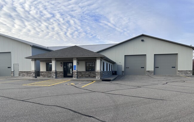

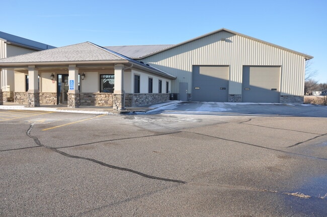

This Property Is For Sale
Current Lease Availabilities
NEARBY LISTINGS FOR SALE OR LEASE
Property Detail
23823-23865 67Th Ave
St. Cloud, MN
Country Square Plat Three
81.43180.0313
LOTS 1 & 2 BLK 1 COUNTRY SQUARE PLAT THREE SECTION 18 TOWNSHIP 123 RANGE 028 COUNTRY SQUARE PLAT THREE SECTION 18 TOWNSHIP
Residentialstoragespaceismainlyappliedtostoragespacesthatareassessedseparatelyfromtheircorrelatedcondos
Stearns
X
Minnesota
27145C0835E
1-2
2025
1 AC
2025
Stearns County
000402
Minneapolis/St Paul
22,380 SF
DEMOGRAPHICS near 23823-23865 67Th Ave
1 mile
3 mile
5 mile
2024 Total Population
485
2,484
12,809
2029 Population
509
2,604
13,374
Pop Growth 2024-2029
+ 4.95%
+ 4.83%
+ 4.41%
Average Age
41
41
40
2024 Total Households
176
930
4,996
HH Growth 2024-2029
+ 5.11%
+ 4.95%
+ 4.50%
Median Household Inc
$107,500
$105,668
$76,942
Avg Household Size
2.70
2.60
2.50
2024 Avg HH Vehicles
3.00
3.00
2.00
Median Home Value
$299,037
$317,778
$284,453
Median Year Built
1991
1991
1995
Nearby Places
Map Layers
Map Styles
 Street
 Aerial
Transit
 Traffic
 Biking
Places
Listings with unknown addresses are not visible on the map
- Restaurants
- Banks
- Shops
- Fitness
- Groceries
PUBLIC TRANSPORTATION
COMMUTER RAIL
St. Cloud Amtrak Station (Empire Builder - Amtrak)
Drive
Walk
Distance
St. Cloud Amtrak Station (Empire Builder - Amtrak)
16 min
10.0 mi
Freight Ports
Port Milwaukee
Drive
Walk
Distance
Port Milwaukee
448 min
405.3 mi
Nearby Properties
Address
Land Use
TOTAL SIZE
Lot Size
Zoning
Address
Land Use
TOTAL SIZE
Lot Size
Zoning
166.84 AC
Address
Land Use
TOTAL SIZE
Lot Size
Zoning
10,996 SF
3.42 AC
Address
Land Use
TOTAL SIZE
Lot Size
Zoning
1,662 SF
14 AC
Address
Land Use
TOTAL SIZE
Lot Size
Zoning
40,226 SF
6.76 AC
Address
Land Use
TOTAL SIZE
Lot Size
Zoning
4,471 SF
62.97 AC
Address
Land Use
TOTAL SIZE
Lot Size
Zoning
8,000 SF
72.09 AC
Address
Land Use
TOTAL SIZE
Lot Size
Zoning
1,260 SF
230 AC
Address
Land Use
TOTAL SIZE
Lot Size
Zoning
1,012 SF
10 AC
Address
Land Use
TOTAL SIZE
Lot Size
Zoning
3,835 SF
45.86 AC
Address
Land Use
TOTAL SIZE
Lot Size
Zoning
6,087 SF
7.92 AC
Address
Land Use
TOTAL SIZE
Lot Size
Zoning
1,422 SF
144.14 AC
RPMKT
Address
Land Use
TOTAL SIZE
Lot Size
Zoning
7,180 SF
72.49 AC
Address
Land Use
TOTAL SIZE
Lot Size
Zoning
3,950 SF
70 AC
Address
Land Use
TOTAL SIZE
Lot Size
Zoning
2,400 SF
185.36 AC
2A
Address
Land Use
TOTAL SIZE
Lot Size
Zoning
4,050 SF
39.50 AC
RPMKT
Address
Land Use
TOTAL SIZE
Lot Size
Zoning
2,176 SF
167.88 AC
2A
Address
Land Use
TOTAL SIZE
Lot Size
Zoning
4,712 SF
160 AC
2AIMP
Address
Land Use
TOTAL SIZE
Lot Size
Zoning
4,309 SF
3.65 AC
Address
Land Use
TOTAL SIZE
Lot Size
Zoning
1,616 SF
160 AC
2A
Address
Land Use
TOTAL SIZE
Lot Size
Zoning
1,792 SF
134.20 AC
Address
Land Use
TOTAL SIZE
Lot Size
Zoning
4,289 SF
16.15 AC
Address
Land Use
TOTAL SIZE
Lot Size
Zoning
960 SF
2.24 AC
Address
Land Use
TOTAL SIZE
Lot Size
Zoning
3,234 SF
100 AC
Address
Land Use
TOTAL SIZE
Lot Size
Zoning
3,667 SF
7.96 AC
Address
Land Use
TOTAL SIZE
Lot Size
Zoning
4,066 SF
19.03 AC
Address
Land Use
TOTAL SIZE
Lot Size
Zoning
8,296 SF
64.60 AC
2B
Address
Land Use
TOTAL SIZE
Lot Size
Zoning
4,128 SF
5.19 AC
The World's #1 Commercial Real Estate Marketplace
Connect with us
© 2026 CoStar Group
The information above has been obtained from sources believed reliable. While we do not doubt its accuracy we have not verified it and make no guarantee, warranty or representation about it. It is your responsibility to independently confirm its accuracy and completeness. Any projections, opinions, assumptions, or estimates used are for example only and do not represent the current or future performance of the property. The value of this transaction to you depends on tax and other factors which should be evaluated by your tax, financial, and legal advisors. You and your advisors should conduct a careful, independent investigation of the property to determine to your satisfaction the suitability of the property for your needs.