Property Record
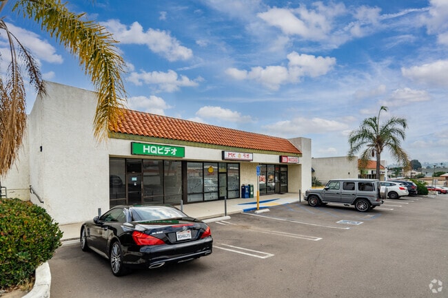
2383 Lomita Blvd, Lomita, CA 90717

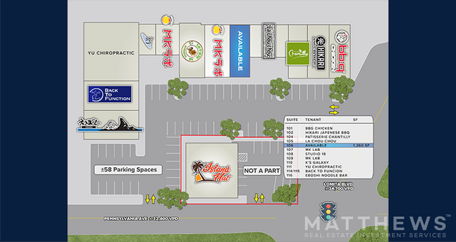

Current Lease Availabilities
NEARBY LISTINGS FOR SALE OR LEASE
Property Detail
2383 Lomita Blvd
Los Angeles-Long Beach-Glendale, CA
15
7374-013-084
TR NO 15 LAND DESC IN DOC 1838663 901031 POR OF LOT 57
Storesoffices
Los Angeles
X
California
06037C1940F
57
2024
1.03 AC
2025
Torrance
670001
Los Angeles
16,860 SF
DEMOGRAPHICS near 2383 Lomita Blvd
1 Mile
3 Mile
5 Mile
2024 Total Population
22,585
192,098
468,240
2029 Population
21,971
186,131
454,235
Pop Growth 2024-2029
(2.72%)
(3.11%)
(2.99%)
Average Age
43
42
42
2024 Total Households
8,299
69,030
164,411
HH Growth 2024-2029
(2.96%)
(3.32%)
(3.17%)
Median Household Inc
$98,473
$95,481
$97,840
Avg Household Size
2.60
2.70
2.70
2024 Avg HH Vehicles
2.00
2.00
2.00
Median Home Value
$777,518
$804,439
$846,047
Median Year Built
1965
1965
1965
Nearby Places
Map Layers
Map Styles
 Street
 Aerial
- Restaurants
- Banks
- Shops
- Fitness
- Groceries
PUBLIC TRANSPORTATION
AIRPORT
Long Beach (Daugherty Field)
DRIVE
WALK
Distance
Long Beach (Daugherty Field)
20 min
11.3 mi
Los Angeles International
DRIVE
WALK
Distance
Los Angeles International
22 min
13.9 mi
Bob Hope
DRIVE
WALK
Distance
Bob Hope
49 min
37.0 mi
Freight Ports
Port of Los Angeles
DRIVE
WALK
Distance
Port of Los Angeles
20 min
9.1 mi
Nearby Properties
Address
Land Use
TOTAL SIZE
Lot Size
Zoning
Address
Land Use
TOTAL SIZE
Lot Size
Zoning
767,582 SF
13.62 AC
TOHHM
Address
Land Use
TOTAL SIZE
Lot Size
Zoning
671,091 SF
18 AC
LAC1
Address
Land Use
TOTAL SIZE
Lot Size
Zoning
997,143 SF
98.35 AC
TOMI-BP
Address
Land Use
TOTAL SIZE
Lot Size
Zoning
267,305 SF
1.59 AC
TOHC-CTR
Address
Land Use
TOTAL SIZE
Lot Size
Zoning
1,261,764 SF
26.51 AC
TOMI-LT
Address
Land Use
TOTAL SIZE
Lot Size
Zoning
267,131 SF
12.10 AC
TOHHM
Address
Land Use
TOTAL SIZE
Lot Size
Zoning
297,420 SF
6.65 AC
TOHC-CTR
Address
Land Use
TOTAL SIZE
Lot Size
Zoning
202,924 SF
6.15 AC
TOHC-CTR
Address
Land Use
TOTAL SIZE
Lot Size
Zoning
246,981 SF
11.95 AC
LARD2
Address
Land Use
TOTAL SIZE
Lot Size
Zoning
131,101 SF
14.03 AC
TOPC-GEN
Address
Land Use
TOTAL SIZE
Lot Size
Zoning
84,365 SF
7.62 AC
LARAS3
Address
Land Use
TOTAL SIZE
Lot Size
Zoning
405,352 SF
7.70 AC
TOHC-CTR
Address
Land Use
TOTAL SIZE
Lot Size
Zoning
103,228 SF
1.19 AC
TORR-HI
Address
Land Use
TOTAL SIZE
Lot Size
Zoning
429,141 SF
3.29 AC
LCM1*
Address
Land Use
TOTAL SIZE
Lot Size
Zoning
100,149 SF
1.99 AC
TORR-MD
Address
Land Use
TOTAL SIZE
Lot Size
Zoning
198,502 SF
LCM2 *
Address
Land Use
TOTAL SIZE
Lot Size
Zoning
174,910 SF
131.43 AC
LAM3
Address
Land Use
TOTAL SIZE
Lot Size
Zoning
81,328 SF
3.13 AC
TOCC-GEN
Address
Land Use
TOTAL SIZE
Lot Size
Zoning
67,581 SF
1.49 AC
OLD PCL003
Address
Land Use
TOTAL SIZE
Lot Size
Zoning
365,701 SF
2.45 AC
TOMI-BP
Address
Land Use
TOTAL SIZE
Lot Size
Zoning
318,052 SF
8.47 AC
TOHC-CTR
Address
Land Use
TOTAL SIZE
Lot Size
Zoning
121,931 SF
6.26 AC
TOHC-CTR
Address
Land Use
TOTAL SIZE
Lot Size
Zoning
10.30 AC
TOM2*
Address
Land Use
TOTAL SIZE
Lot Size
Zoning
287,730 SF
10.33 AC
TOHC-CTR
Address
Land Use
TOTAL SIZE
Lot Size
Zoning
1,005,037 SF
23.98 AC
TOMI-LT
Address
Land Use
TOTAL SIZE
Lot Size
Zoning
169,576 SF
8.40 AC
TOMI-BP
The World's #1 Commercial Real Estate Marketplace
Connect with us
© 2026 CoStar Group
The information above has been obtained from sources believed reliable. While we do not doubt its accuracy we have not verified it and make no guarantee, warranty or representation about it. It is your responsibility to independently confirm its accuracy and completeness. Any projections, opinions, assumptions, or estimates used are for example only and do not represent the current or future performance of the property. The value of this transaction to you depends on tax and other factors which should be evaluated by your tax, financial, and legal advisors. You and your advisors should conduct a careful, independent investigation of the property to determine to your satisfaction the suitability of the property for your needs.