Property Record
23835 State Road 40, Astor, FL 32102

Save to a Folder
{{folder.Name}}
{{folder.ListingIds.length}} Properties
{{folder.ListingIds.length}} Property
Create a New Folder
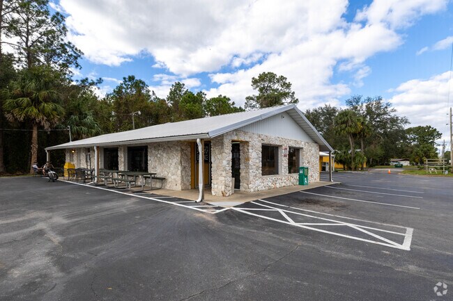
Property Detail
23835 State Road 40
07-15-27-0100-000-02800
MANHATTAN SEC 1 BEG AT INTERSECTION OF N R/W LINE OF SR 40 AND W LINE OF LOT 28 RUN N 00DEG 24MIN 37SEC E 569.93 FT E 100 FT S 00DEG 24MIN 37SEC W 569.94 FT W ALONG HWY R/W 100 FT TO POB PB 2 PG 13 ORB 5452 PG 2302
Officebuilding
LAKE
C2
Florida
B and X Area of moderate flood hazard, usually the area between the limits of the 100-year and 500-year floods.
28
2024
1.30 AC
2026
Lake County
030102
Orlando
4,144 SF
Orlando-Kissimmee-Sanford, FL
NEARBY LISTINGS FOR SALE OR LEASE
-
-
View all Astor listings for sale on LoopNet.com
DEMOGRAPHICS near 23835 State Road 40
1 mile
3 mile
5 mile
2025 Total Population
1,821
3,970
4,472
2030 Population
2,129
4,567
5,126
Pop Growth 2025-2030
+ 16.91%
+ 15.04%
+ 14.62%
Average Age
49
48
48
2025 Total Households
803
1,750
1,966
HH Growth 2025-2030
+ 17.06%
+ 15.09%
+ 14.70%
Median Household Inc
$56,585
$58,061
$58,429
Avg Household Size
2.20
2.20
2.20
2025 Avg HH Vehicles
2.00
2.00
2.00
Median Home Value
$151,449
$186,870
$196,864
Median Year Built
1982
1982
1982
Nearby Places
Map Layers
Map Styles
 Street
 Aerial
Layers
 Traffic
 Biking
Places
Listings with unknown addresses are not visible on the map
- Restaurants
- Banks
- Shops
- Fitness
- Groceries
PUBLIC TRANSPORTATION
AIRPORT
Daytona Beach International
Drive
Walk
Distance
Daytona Beach International
52 min
36.4 mi
Orlando Sanford International
Drive
Walk
Distance
Orlando Sanford International
73 min
48.0 mi
Nearby Properties
Address
Land Use
TOTAL SIZE
Lot Size
Zoning
Address
Land Use
TOTAL SIZE
Lot Size
Zoning
491.13 AC
A
Address
Land Use
TOTAL SIZE
Lot Size
Zoning
639.34 AC
A
Address
Land Use
TOTAL SIZE
Lot Size
Zoning
387.93 AC
A
Address
Land Use
TOTAL SIZE
Lot Size
Zoning
3,812 SF
86.64 AC
01B7
Address
Land Use
TOTAL SIZE
Lot Size
Zoning
397.63 AC
A
Address
Land Use
TOTAL SIZE
Lot Size
Zoning
637.73 AC
A
Address
Land Use
TOTAL SIZE
Lot Size
Zoning
384.69 AC
A
Address
Land Use
TOTAL SIZE
Lot Size
Zoning
18,998 SF
2.33 AC
B7
Address
Land Use
TOTAL SIZE
Lot Size
Zoning
589.68 AC
A
Address
Land Use
TOTAL SIZE
Lot Size
Zoning
571.72 AC
A
Address
Land Use
TOTAL SIZE
Lot Size
Zoning
560.44 AC
A
Address
Land Use
TOTAL SIZE
Lot Size
Zoning
563.26 AC
A
Address
Land Use
TOTAL SIZE
Lot Size
Zoning
14,088 SF
7.10 AC
01B7
Address
Land Use
TOTAL SIZE
Lot Size
Zoning
416.11 AC
A
Address
Land Use
TOTAL SIZE
Lot Size
Zoning
23,264 SF
2.46 AC
CFD
Address
Land Use
TOTAL SIZE
Lot Size
Zoning
310.01 AC
A
Address
Land Use
TOTAL SIZE
Lot Size
Zoning
643.98 AC
C
Address
Land Use
TOTAL SIZE
Lot Size
Zoning
633.01 AC
RC
Address
Land Use
TOTAL SIZE
Lot Size
Zoning
256.93 AC
A
Address
Land Use
TOTAL SIZE
Lot Size
Zoning
8,322 SF
144.32 AC
RC
Address
Land Use
TOTAL SIZE
Lot Size
Zoning
203.46 AC
A
Address
Land Use
TOTAL SIZE
Lot Size
Zoning
4,121 SF
9.34 AC
C1
Address
Land Use
TOTAL SIZE
Lot Size
Zoning
125.70 AC
A
Address
Land Use
TOTAL SIZE
Lot Size
Zoning
472.71 AC
C
Address
Land Use
TOTAL SIZE
Lot Size
Zoning
175.06 AC
A
Address
Land Use
TOTAL SIZE
Lot Size
Zoning
6,480 SF
0.73 AC
C1
Address
Land Use
TOTAL SIZE
Lot Size
Zoning
6,464 SF
1.02 AC
B4
Address
Land Use
TOTAL SIZE
Lot Size
Zoning
16,524 SF
1.31 AC
CP
Address
Land Use
TOTAL SIZE
Lot Size
Zoning
864 SF
0.55 AC
01MH5
Address
Land Use
TOTAL SIZE
Lot Size
Zoning
9,230 SF
4.26 AC
CP
The World's #1 Commercial Real Estate Marketplace
Connect with us
© 2026 CoStar Group
The information above has been obtained from sources believed reliable. While we do not doubt its accuracy we have not verified it and make no guarantee, warranty or representation about it. It is your responsibility to independently confirm its accuracy and completeness. Any projections, opinions, assumptions, or estimates used are for example only and do not represent the current or future performance of the property. The value of this transaction to you depends on tax and other factors which should be evaluated by your tax, financial, and legal advisors. You and your advisors should conduct a careful, independent investigation of the property to determine to your satisfaction the suitability of the property for your needs.