Property Record
2385 112Th Ave, Holland, MI 49424

Save to a Folder
{{folder.Name}}
{{folder.ListingIds.length}} Properties
{{folder.ListingIds.length}} Property
Create a New Folder
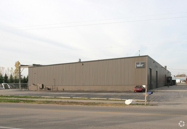
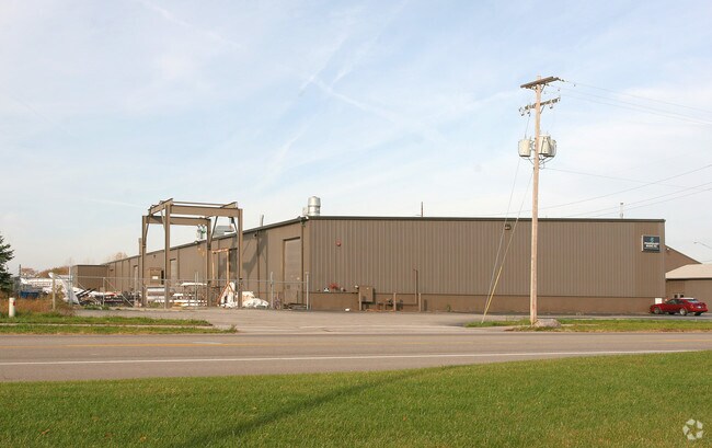
Property Detail
2385 112Th Ave
70-16-22-200-073
PART OF NE 1/4 COM NE SEC COR, TH N 89D 46M 09S W 53 FT TO PT OF BEG, TH S 0D 27M 29S W 33 FT, S 44D 39M 20S E 2823 FT, S 89D
Lightindustrial
Ottawa
I-2
Michigan
B and X Area of moderate flood hazard, usually the area between the limits of the 100-year and 500-year floods.
13.13 AC
2025
Holland East
2025
West Michigan
022206
Grand Rapids-Wyoming-Kentwood, MI
80,969 SF
NEARBY LISTINGS FOR SALE OR LEASE
DEMOGRAPHICS near 2385 112Th Ave
1 mile
3 mile
5 mile
2025 Total Population
3,377
44,642
90,480
2030 Population
3,476
45,617
92,196
Pop Growth 2025-2030
+ 2.93%
+ 2.18%
+ 1.90%
Average Age
43
39
39
2025 Total Households
1,275
16,640
33,187
HH Growth 2025-2030
+ 3.14%
+ 2.43%
+ 2.05%
Median Household Inc
$82,591
$74,638
$76,336
Avg Household Size
2.60
2.50
2.60
2025 Avg HH Vehicles
2.00
2.00
2.00
Median Home Value
$303,463
$289,252
$279,695
Median Year Built
1993
1991
1985
Nearby Places
Map Layers
Map Styles
 Street
 Aerial
Layers
 Traffic
 Biking
Places
Listings with unknown addresses are not visible on the map
- Restaurants
- Banks
- Shops
- Fitness
- Groceries
PUBLIC TRANSPORTATION
COMMUTER RAIL
Holland Amtrak Station (Pere Marquette - Amtrak)
Drive
Walk
Distance
Holland Amtrak Station (Pere Marquette - Amtrak)
7 min
3.0 mi
AIRPORT
Gerald R Ford International
Drive
Walk
Distance
Gerald R Ford International
43 min
32.0 mi
Freight Ports
Port Milwaukee
Drive
Walk
Distance
Port Milwaukee
282 min
238.9 mi
Nearby Properties
Address
Land Use
TOTAL SIZE
Lot Size
Zoning
Address
Land Use
TOTAL SIZE
Lot Size
Zoning
1,134,118 SF
73.70 AC
I-2
Address
Land Use
TOTAL SIZE
Lot Size
Zoning
572,832 SF
10.89 AC
PUD
Address
Land Use
TOTAL SIZE
Lot Size
Zoning
255,407 SF
23.18 AC
I-2
Address
Land Use
TOTAL SIZE
Lot Size
Zoning
682,378 SF
99.60 AC
NA
Address
Land Use
TOTAL SIZE
Lot Size
Zoning
349,583 SF
I
Address
Land Use
TOTAL SIZE
Lot Size
Zoning
662,015 SF
177 AC
SEE MAP
Address
Land Use
TOTAL SIZE
Lot Size
Zoning
377,049 SF
24.47 AC
I-2
Address
Land Use
TOTAL SIZE
Lot Size
Zoning
346,440 SF
32.15 AC
PUD
Address
Land Use
TOTAL SIZE
Lot Size
Zoning
362,916 SF
19.23 AC
I-2
Address
Land Use
TOTAL SIZE
Lot Size
Zoning
391,255 SF
40.67 AC
I-2
Address
Land Use
TOTAL SIZE
Lot Size
Zoning
249,051 SF
24.77 AC
LDR
Address
Land Use
TOTAL SIZE
Lot Size
Zoning
3,150 SF
25.40 AC
AG
Address
Land Use
TOTAL SIZE
Lot Size
Zoning
594,031 SF
R-1
Address
Land Use
TOTAL SIZE
Lot Size
Zoning
660,002 SF
32.13 AC
I-2
Address
Land Use
TOTAL SIZE
Lot Size
Zoning
218,722 SF
8.59 AC
AGR
Address
Land Use
TOTAL SIZE
Lot Size
Zoning
176,802 SF
17.58 AC
AG
Address
Land Use
TOTAL SIZE
Lot Size
Zoning
320,270 SF
33.25 AC
PUD
Address
Land Use
TOTAL SIZE
Lot Size
Zoning
82,556 SF
Address
Land Use
TOTAL SIZE
Lot Size
Zoning
259,200 SF
R-1
Address
Land Use
TOTAL SIZE
Lot Size
Zoning
226,347 SF
19.44 AC
I-2
Address
Land Use
TOTAL SIZE
Lot Size
Zoning
132,127 SF
42.69 AC
SEE MAP
Address
Land Use
TOTAL SIZE
Lot Size
Zoning
35,715 SF
Address
Land Use
TOTAL SIZE
Lot Size
Zoning
19.20 AC
AG
Address
Land Use
TOTAL SIZE
Lot Size
Zoning
90,508 SF
I-2
Address
Land Use
TOTAL SIZE
Lot Size
Zoning
210,792 SF
22.91 AC
C-2
Address
Land Use
TOTAL SIZE
Lot Size
Zoning
94,790 SF
1.74 AC
C-2
Address
Land Use
TOTAL SIZE
Lot Size
Zoning
58,710 SF
6.96 AC
C-2
Address
Land Use
TOTAL SIZE
Lot Size
Zoning
209,455 SF
17 AC
C-2
Address
Land Use
TOTAL SIZE
Lot Size
Zoning
134,490 SF
15.76 AC
C-2
Address
Land Use
TOTAL SIZE
Lot Size
Zoning
149,348 SF
9.22 AC
I-2
The World's #1 Commercial Real Estate Marketplace
Connect with us
© 2026 CoStar Group
The information above has been obtained from sources believed reliable. While we do not doubt its accuracy we have not verified it and make no guarantee, warranty or representation about it. It is your responsibility to independently confirm its accuracy and completeness. Any projections, opinions, assumptions, or estimates used are for example only and do not represent the current or future performance of the property. The value of this transaction to you depends on tax and other factors which should be evaluated by your tax, financial, and legal advisors. You and your advisors should conduct a careful, independent investigation of the property to determine to your satisfaction the suitability of the property for your needs.