Property Record
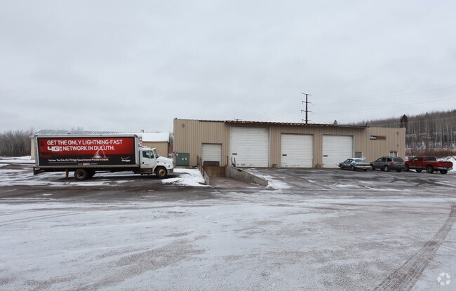
2385 Becks Rd, Duluth, MN 55810


Property Detail
2385 Becks Rd
010274205060
THAT PART OF NW 1/4 OF SE 1/4 LYING NAND E OF THE SPIRIT LAKE RY RT OF WAY SERIAL #
Manufacturinglight
Saint Louis
B and X Area of moderate flood hazard, usually the area between the limits of the 100-year and 500-year floods.
Minnesota
2026
7 AC
2024
South St Louis County
010200
Duluth
6,000 SF
Duluth, MN-WI
NEARBY LISTINGS FOR SALE OR LEASE
-
-
View all Duluth listings for sale on LoopNet.com
DEMOGRAPHICS near 2385 Becks Rd
1 mile
3 mile
5 mile
2025 Total Population
51
6,214
14,905
2030 Population
51
6,172
14,714
Pop Growth 2025-2030
0.00%
(0.68%)
(1.28%)
Average Age
44
41
42
2025 Total Households
21
2,633
6,178
HH Growth 2025-2030
0.00%
(0.68%)
(1.34%)
Median Household Inc
$93,749
$66,514
$74,202
Avg Household Size
2.20
2.20
2.30
2025 Avg HH Vehicles
2.00
2.00
2.00
Median Home Value
$269,999
$185,008
$221,715
Median Year Built
1975
1954
1963
Nearby Places
Map Layers
Map Styles
 Street
 Aerial
Layers
 Traffic
 Biking
Places
Listings with unknown addresses are not visible on the map
- Restaurants
- Banks
- Shops
- Fitness
- Groceries
PUBLIC TRANSPORTATION
AIRPORT
Duluth International
Drive
Walk
Distance
Duluth International
28 min
15.8 mi
Nearby Properties
Address
Land Use
TOTAL SIZE
Lot Size
Zoning
Address
Land Use
TOTAL SIZE
Lot Size
Zoning
82,679 SF
3.27 AC
Address
Land Use
TOTAL SIZE
Lot Size
Zoning
8,344 SF
65.40 AC
Address
Land Use
TOTAL SIZE
Lot Size
Zoning
58,368 SF
7.10 AC
Address
Land Use
TOTAL SIZE
Lot Size
Zoning
284,827 SF
47.09 AC
Address
Land Use
TOTAL SIZE
Lot Size
Zoning
59,368 SF
0.46 AC
R1C
Address
Land Use
TOTAL SIZE
Lot Size
Zoning
47,993 SF
2.72 AC
R2
Address
Land Use
TOTAL SIZE
Lot Size
Zoning
27,275 SF
112.47 AC
Address
Land Use
TOTAL SIZE
Lot Size
Zoning
38,160 SF
2.28 AC
Address
Land Use
TOTAL SIZE
Lot Size
Zoning
38,160 SF
1.97 AC
Address
Land Use
TOTAL SIZE
Lot Size
Zoning
6,970 SF
31.98 AC
R1C
Address
Land Use
TOTAL SIZE
Lot Size
Zoning
7,800 SF
3.33 AC
R3
Address
Land Use
TOTAL SIZE
Lot Size
Zoning
1,395 SF
8.50 AC
R1C
Address
Land Use
TOTAL SIZE
Lot Size
Zoning
39.98 AC
C1
Address
Land Use
TOTAL SIZE
Lot Size
Zoning
9,825 SF
2.16 AC
Address
Land Use
TOTAL SIZE
Lot Size
Zoning
20,746 SF
4.41 AC
Address
Land Use
TOTAL SIZE
Lot Size
Zoning
20,876 SF
1.33 AC
Address
Land Use
TOTAL SIZE
Lot Size
Zoning
20,800 SF
Address
Land Use
TOTAL SIZE
Lot Size
Zoning
20,800 SF
Address
Land Use
TOTAL SIZE
Lot Size
Zoning
20,800 SF
Address
Land Use
TOTAL SIZE
Lot Size
Zoning
20,800 SF
Address
Land Use
TOTAL SIZE
Lot Size
Zoning
20,800 SF
2.07 AC
Address
Land Use
TOTAL SIZE
Lot Size
Zoning
20,800 SF
Address
Land Use
TOTAL SIZE
Lot Size
Zoning
20,800 SF
Address
Land Use
TOTAL SIZE
Lot Size
Zoning
8,928 SF
1.03 AC
R3
Address
Land Use
TOTAL SIZE
Lot Size
Zoning
3,862 SF
40 AC
Address
Land Use
TOTAL SIZE
Lot Size
Zoning
6,800 SF
18.10 AC
Address
Land Use
TOTAL SIZE
Lot Size
Zoning
17,600 SF
29.50 AC
Address
Land Use
TOTAL SIZE
Lot Size
Zoning
5,620 SF
0.49 AC
Address
Land Use
TOTAL SIZE
Lot Size
Zoning
26,066 SF
1.29 AC
C1
Address
Land Use
TOTAL SIZE
Lot Size
Zoning
11,660 SF
1.24 AC
The World's #1 Commercial Real Estate Marketplace
Connect with us
© 2026 CoStar Group
The information above has been obtained from sources believed reliable. While we do not doubt its accuracy we have not verified it and make no guarantee, warranty or representation about it. It is your responsibility to independently confirm its accuracy and completeness. Any projections, opinions, assumptions, or estimates used are for example only and do not represent the current or future performance of the property. The value of this transaction to you depends on tax and other factors which should be evaluated by your tax, financial, and legal advisors. You and your advisors should conduct a careful, independent investigation of the property to determine to your satisfaction the suitability of the property for your needs.