Property Record
239 Howard St Ne, Atlanta, GA 30317
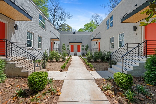


This Property Is For Sale
NEARBY LISTINGS FOR SALE OR LEASE
Property Detail
239 Howard St Ne
15-211-02-153
BEG AT THE E SIDE OF HOWARD ST
Apartment
DeKalb
X
Georgia
13089C0064K
12
2025
0.64 AC
2025
Kirkwood
020801
Atlanta
5,642 SF
Atlanta-Sandy Springs-Roswell, GA
DEMOGRAPHICS near 239 Howard St Ne
1 Mile
3 Mile
5 Mile
2024 Total Population
16,732
139,921
380,808
2029 Population
16,838
141,358
388,443
Pop Growth 2024-2029
+ 0.63%
+ 1.03%
+ 2.00%
Average Age
37
38
37
2024 Total Households
7,030
64,188
173,706
HH Growth 2024-2029
+ 0.64%
+ 1.22%
+ 2.29%
Median Household Inc
$126,577
$109,142
$84,762
Avg Household Size
2.30
2.10
2.00
2024 Avg HH Vehicles
2.00
2.00
1.00
Median Home Value
$603,331
$557,252
$446,583
Median Year Built
1959
1970
1984
Nearby Places
Map Layers
Map Styles
 Street
 Aerial
- Restaurants
- Banks
- Shops
- Fitness
- Groceries
PUBLIC TRANSPORTATION
TRANSIT/SUBWAY
East Lake (Blue Line - Metropolitan Atlanta Rapid Transit Authority (MARTA))
DRIVE
WALK
Distance
East Lake (Blue Line - Metropolitan Atlanta Rapid Transit Authority (MARTA))
2 min
16 min
0.8 mi
COMMUTER RAIL
Atlanta (Crescent - Amtrak)
DRIVE
WALK
Distance
Atlanta (Crescent - Amtrak)
15 min
7.4 mi
AIRPORT
Hartsfield - Jackson Atlanta International
DRIVE
WALK
Distance
Hartsfield - Jackson Atlanta International
23 min
13.7 mi
Freight Ports
Georgia Ports - Savannah
DRIVE
WALK
Distance
Georgia Ports - Savannah
283 min
247.8 mi
Nearby Properties
Address
Land Use
TOTAL SIZE
Lot Size
Zoning
Address
Land Use
TOTAL SIZE
Lot Size
Zoning
2,283,599 SF
12.93 AC
I1
Address
Land Use
TOTAL SIZE
Lot Size
Zoning
467,847 SF
1.62 AC
I2
Address
Land Use
TOTAL SIZE
Lot Size
Zoning
2,612 SF
137.60 AC
X
Address
Land Use
TOTAL SIZE
Lot Size
Zoning
1,121,700 SF
2.21 AC
I2
Address
Land Use
TOTAL SIZE
Lot Size
Zoning
345,125 SF
7.73 AC
C1
Address
Land Use
TOTAL SIZE
Lot Size
Zoning
0.91 AC
I1
Address
Land Use
TOTAL SIZE
Lot Size
Zoning
736,752 SF
3.86 AC
C1
Address
Land Use
TOTAL SIZE
Lot Size
Zoning
543,748 SF
3.86 AC
I2
Address
Land Use
TOTAL SIZE
Lot Size
Zoning
188,469 SF
4.06 AC
C-1
Address
Land Use
TOTAL SIZE
Lot Size
Zoning
230,911 SF
6.29 AC
X
Address
Land Use
TOTAL SIZE
Lot Size
Zoning
400,311 SF
4.45 AC
I2
Address
Land Use
TOTAL SIZE
Lot Size
Zoning
123,732 SF
0.51 AC
RM75
Address
Land Use
TOTAL SIZE
Lot Size
Zoning
327,098 SF
4.92 AC
X
Address
Land Use
TOTAL SIZE
Lot Size
Zoning
398,215 SF
3.19 AC
C1
Address
Land Use
TOTAL SIZE
Lot Size
Zoning
99,770 SF
2.14 AC
Address
Land Use
TOTAL SIZE
Lot Size
Zoning
959,348 SF
7.28 AC
PDMU
Address
Land Use
TOTAL SIZE
Lot Size
Zoning
548,615 SF
4.52 AC
I1
Address
Land Use
TOTAL SIZE
Lot Size
Zoning
543,551 SF
5.26 AC
R4
Address
Land Use
TOTAL SIZE
Lot Size
Zoning
290,130 SF
6.13 AC
R100
Address
Land Use
TOTAL SIZE
Lot Size
Zoning
225,500 SF
9.74 AC
RM75
Address
Land Use
TOTAL SIZE
Lot Size
Zoning
397,758 SF
1.91 AC
I1
Address
Land Use
TOTAL SIZE
Lot Size
Zoning
495,740 SF
2.65 AC
C1
Address
Land Use
TOTAL SIZE
Lot Size
Zoning
566,872 SF
3.31 AC
I1
Address
Land Use
TOTAL SIZE
Lot Size
Zoning
67,882 SF
4.77 AC
X
Address
Land Use
TOTAL SIZE
Lot Size
Zoning
491,862 SF
2.44 AC
R4
Address
Land Use
TOTAL SIZE
Lot Size
Zoning
624,087 SF
4.45 AC
I2
Address
Land Use
TOTAL SIZE
Lot Size
Zoning
732,568 SF
8.14 AC
C2
Address
Land Use
TOTAL SIZE
Lot Size
Zoning
9,828 SF
2.46 AC
C1
Address
Land Use
TOTAL SIZE
Lot Size
Zoning
390,107 SF
4.98 AC
C1
Address
Land Use
TOTAL SIZE
Lot Size
Zoning
438,163 SF
4.45 AC
R5
The World's #1 Commercial Real Estate Marketplace
Connect with us
© 2026 CoStar Group
The information above has been obtained from sources believed reliable. While we do not doubt its accuracy we have not verified it and make no guarantee, warranty or representation about it. It is your responsibility to independently confirm its accuracy and completeness. Any projections, opinions, assumptions, or estimates used are for example only and do not represent the current or future performance of the property. The value of this transaction to you depends on tax and other factors which should be evaluated by your tax, financial, and legal advisors. You and your advisors should conduct a careful, independent investigation of the property to determine to your satisfaction the suitability of the property for your needs.