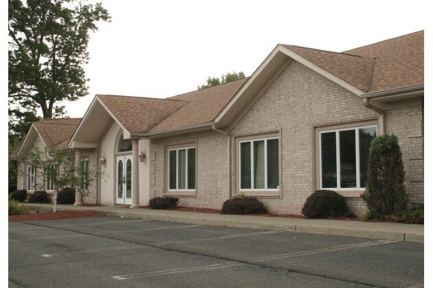
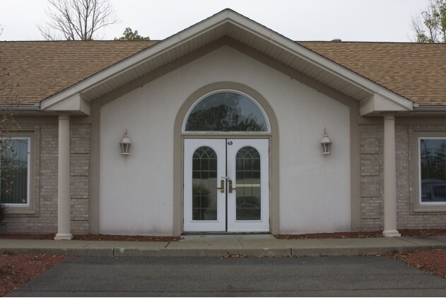
Property Record
239 Lakeside Rd, Newburgh, NY 12550
Property Detail
239 Lakeside Rd
Kiryas Joel-Poughkeepsie-Newburgh, NY
Orange
334600-051-000-0005-018.000-0000
New York
Commercialbuilding
37.00
B and X Area of moderate flood hazard, usually the area between the limits of the 100-year and 500-year floods.
1.10 AC
2024
Newburgh
2025
Northern New Jersey
000600
NEARBY LISTINGS FOR SALE OR LEASE
DEMOGRAPHICS near 239 Lakeside Rd
1 mile
3 mile
5 mile
2025 Total Population
3,670
18,682
60,564
2030 Population
3,740
19,109
61,413
Pop Growth 2025-2030
+ 1.91%
+ 2.29%
+ 1.40%
Average Age
43
42
40
2025 Total Households
1,388
6,824
21,655
HH Growth 2025-2030
+ 2.02%
+ 2.34%
+ 1.46%
Median Household Inc
$114,593
$100,320
$91,591
Avg Household Size
2.60
2.60
2.70
2025 Avg HH Vehicles
2.00
2.00
2.00
Median Home Value
$373,363
$348,006
$353,190
Median Year Built
1990
1976
1968
Nearby Places
Map Layers
Map Styles
 Street
 Aerial
Layers
 Traffic
 Biking
Places
Listings with unknown addresses are not visible on the map
- Restaurants
- Banks
- Shops
- Fitness
- Groceries
PUBLIC TRANSPORTATION
COMMUTER RAIL
Beacon Station (Hudson Line - Metro-North Commuter Railroad Company (Metro-North))
Drive
Walk
Distance
Beacon Station (Hudson Line - Metro-North Commuter Railroad Company (Metro-North))
16 min
8.7 mi
AIRPORT
New York Stewart International
Drive
Walk
Distance
New York Stewart International
14 min
6.2 mi
SALE & LEASE HISTORY
LISTING DATE
SALE/LEASE

Oct 12, 2017
For Lease
Mar 24, 2019
For Lease
Aug 28, 2017
For Lease
Apr 27, 2018
For Lease
Nearby Properties
Address
Land Use
TOTAL SIZE
Lot Size
Zoning
Address
Land Use
TOTAL SIZE
Lot Size
Zoning
1,013,616 SF
186.68 AC
I1
Address
Land Use
TOTAL SIZE
Lot Size
Zoning
1,015,632 SF
187.79 AC
I1
Address
Land Use
TOTAL SIZE
Lot Size
Zoning
927,041 SF
104.37 AC
Address
Land Use
TOTAL SIZE
Lot Size
Zoning
130,037 SF
136 AC
Address
Land Use
TOTAL SIZE
Lot Size
Zoning
8.50 AC
AP
Address
Land Use
TOTAL SIZE
Lot Size
Zoning
739.80 AC
Address
Land Use
TOTAL SIZE
Lot Size
Zoning
71.72 AC
Address
Land Use
TOTAL SIZE
Lot Size
Zoning
44.50 AC
Address
Land Use
TOTAL SIZE
Lot Size
Zoning
505,577 SF
50.50 AC
Address
Land Use
TOTAL SIZE
Lot Size
Zoning
29,935 SF
31.60 AC
04
Address
Land Use
TOTAL SIZE
Lot Size
Zoning
71,379 SF
20.80 AC
Address
Land Use
TOTAL SIZE
Lot Size
Zoning
20.90 AC
Address
Land Use
TOTAL SIZE
Lot Size
Zoning
73,585 SF
5.60 AC
04
Address
Land Use
TOTAL SIZE
Lot Size
Zoning
10.30 AC
Address
Land Use
TOTAL SIZE
Lot Size
Zoning
215,219 SF
14.57 AC
Address
Land Use
TOTAL SIZE
Lot Size
Zoning
Address
Land Use
TOTAL SIZE
Lot Size
Zoning
653 AC
AP
Address
Land Use
TOTAL SIZE
Lot Size
Zoning
132,000 SF
14.90 AC
Address
Land Use
TOTAL SIZE
Lot Size
Zoning
Address
Land Use
TOTAL SIZE
Lot Size
Zoning
137,765 SF
14 AC
Address
Land Use
TOTAL SIZE
Lot Size
Zoning
62,458 SF
7.20 AC
Address
Land Use
TOTAL SIZE
Lot Size
Zoning
99,030 SF
5.90 AC
Address
Land Use
TOTAL SIZE
Lot Size
Zoning
Address
Land Use
TOTAL SIZE
Lot Size
Zoning
75,620 SF
12.80 AC
Address
Land Use
TOTAL SIZE
Lot Size
Zoning
149,085 SF
48.90 AC
Address
Land Use
TOTAL SIZE
Lot Size
Zoning
61,822 SF
7.30 AC
Address
Land Use
TOTAL SIZE
Lot Size
Zoning
Address
Land Use
TOTAL SIZE
Lot Size
Zoning
3.20 AC
Address
Land Use
TOTAL SIZE
Lot Size
Zoning
12.30 AC
Address
Land Use
TOTAL SIZE
Lot Size
Zoning
The World's #1 Commercial Real Estate Marketplace
Connect with us
© 2026 CoStar Group
The information above has been obtained from sources believed reliable. While we do not doubt its accuracy we have not verified it and make no guarantee, warranty or representation about it. It is your responsibility to independently confirm its accuracy and completeness. Any projections, opinions, assumptions, or estimates used are for example only and do not represent the current or future performance of the property. The value of this transaction to you depends on tax and other factors which should be evaluated by your tax, financial, and legal advisors. You and your advisors should conduct a careful, independent investigation of the property to determine to your satisfaction the suitability of the property for your needs.