Property Record
239 Main St, Danielson, CT 06239
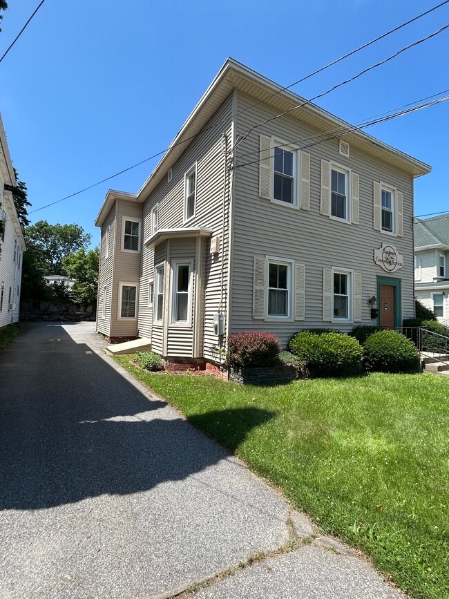


This Property Is For Sale
Property Detail
239 Main St
Sfr
Windham
X
Connecticut
09015C0242F
0.17 AC
2025
Windham County
2025
Hartford
904500
Willimantic, CT
3,391 SF
KILL-000181-000000-000129
NEARBY LISTINGS FOR SALE OR LEASE
-
-
View all Danielson listings for sale on LoopNet.com
DEMOGRAPHICS near 239 Main St
1 mile
3 mile
5 mile
2024 Total Population
6,923
16,372
27,232
2029 Population
7,080
16,464
27,206
Pop Growth 2024-2029
+ 2.27%
+ 0.56%
(0.10%)
Average Age
41
42
42
2024 Total Households
2,917
6,767
10,821
HH Growth 2024-2029
+ 2.30%
+ 0.62%
(0.05%)
Median Household Inc
$61,285
$70,806
$76,462
Avg Household Size
2.30
2.30
2.40
2024 Avg HH Vehicles
2.00
2.00
2.00
Median Home Value
$178,703
$231,823
$244,117
Median Year Built
1949
1967
1971
Nearby Places
Map Layers
Map Styles
 Street
 Aerial
Transit
 Traffic
 Biking
Places
Listings with unknown addresses are not visible on the map
- Restaurants
- Banks
- Shops
- Fitness
- Groceries
PUBLIC TRANSPORTATION
AIRPORT
Rhode Island Tf Green International
Drive
Walk
Distance
Rhode Island Tf Green International
44 min
32.4 mi
Worcester Regional
Drive
Walk
Distance
Worcester Regional
50 min
36.1 mi
Freight Ports
Port of Davisville, RI
Drive
Walk
Distance
Port of Davisville, RI
56 min
41.6 mi
Nearby Properties
Address
Land Use
TOTAL SIZE
Lot Size
Zoning
Address
Land Use
TOTAL SIZE
Lot Size
Zoning
203,150 SF
21 AC
LD
Address
Land Use
TOTAL SIZE
Lot Size
Zoning
22 AC
I
Address
Land Use
TOTAL SIZE
Lot Size
Zoning
62 AC
LD
Address
Land Use
TOTAL SIZE
Lot Size
Zoning
47 AC
MUI
Address
Land Use
TOTAL SIZE
Lot Size
Zoning
53,306 SF
1.60 AC
BI
Address
Land Use
TOTAL SIZE
Lot Size
Zoning
139,010 SF
16.75 AC
MUI
Address
Land Use
TOTAL SIZE
Lot Size
Zoning
227 AC
LD
Address
Land Use
TOTAL SIZE
Lot Size
Zoning
147,139 SF
25.48 AC
PC
Address
Land Use
TOTAL SIZE
Lot Size
Zoning
148,118 SF
17 AC
BRHD
Address
Land Use
TOTAL SIZE
Lot Size
Zoning
126,601 SF
13.40 AC
MUI
Address
Land Use
TOTAL SIZE
Lot Size
Zoning
864 SF
50 AC
VC/LD
Address
Land Use
TOTAL SIZE
Lot Size
Zoning
6.61 AC
MUI
Address
Land Use
TOTAL SIZE
Lot Size
Zoning
59,552 SF
4.28 AC
GC
Address
Land Use
TOTAL SIZE
Lot Size
Zoning
50,707 SF
10.50 AC
BRHD
Address
Land Use
TOTAL SIZE
Lot Size
Zoning
7.07 AC
GC
Address
Land Use
TOTAL SIZE
Lot Size
Zoning
10.50 AC
GC
Address
Land Use
TOTAL SIZE
Lot Size
Zoning
67,994 SF
8.30 AC
GC
Address
Land Use
TOTAL SIZE
Lot Size
Zoning
12,982 SF
1.54 AC
GC
Address
Land Use
TOTAL SIZE
Lot Size
Zoning
48,032 SF
9.40 AC
LD
Address
Land Use
TOTAL SIZE
Lot Size
Zoning
15 AC
I
Address
Land Use
TOTAL SIZE
Lot Size
Zoning
9.77 AC
PC
Address
Land Use
TOTAL SIZE
Lot Size
Zoning
45,960 SF
1.40 AC
MD
Address
Land Use
TOTAL SIZE
Lot Size
Zoning
19.85 AC
R30
Address
Land Use
TOTAL SIZE
Lot Size
Zoning
7,808 SF
6.90 AC
I
Address
Land Use
TOTAL SIZE
Lot Size
Zoning
9.80 AC
GC
Address
Land Use
TOTAL SIZE
Lot Size
Zoning
12.20 AC
MD
Address
Land Use
TOTAL SIZE
Lot Size
Zoning
18,958 SF
1.52 AC
BGC
Address
Land Use
TOTAL SIZE
Lot Size
Zoning
9.12 AC
R10
Address
Land Use
TOTAL SIZE
Lot Size
Zoning
13,472 SF
1.40 AC
PC
Address
Land Use
TOTAL SIZE
Lot Size
Zoning
14,524 SF
0.92 AC
RHD
The World's #1 Commercial Real Estate Marketplace
Connect with us
© 2026 CoStar Group
The information above has been obtained from sources believed reliable. While we do not doubt its accuracy we have not verified it and make no guarantee, warranty or representation about it. It is your responsibility to independently confirm its accuracy and completeness. Any projections, opinions, assumptions, or estimates used are for example only and do not represent the current or future performance of the property. The value of this transaction to you depends on tax and other factors which should be evaluated by your tax, financial, and legal advisors. You and your advisors should conduct a careful, independent investigation of the property to determine to your satisfaction the suitability of the property for your needs.