Property Record
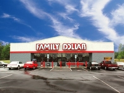
239 State Highway 66, Rockwall, TX 75087

Property Detail
239 State Highway 66
65637
FATE O T (RWISD), BLOCK U NORTH PART AND PT OF ROAD FKA HAW RD, ACRES 1.052
Commercialnec
ROCKWALL
A Areas with a 1% annual chance of flooding and a 26% chance of flooding over the life of a 30-year mortgage.
Texas
2024
1.05 AC
2025
East Dallas Outlying
040406
Dallas/Ft Worth
8,320 SF
Dallas-Fort Worth-Arlington, TX
NEARBY LISTINGS FOR SALE OR LEASE
DEMOGRAPHICS near 239 State Highway 66
1 mile
3 mile
5 mile
2025 Total Population
13,169
35,794
82,743
2030 Population
15,797
43,356
99,778
Pop Growth 2025-2030
+ 19.96%
+ 21.13%
+ 20.59%
Average Age
34
35
36
2025 Total Households
4,044
11,051
27,100
HH Growth 2025-2030
+ 19.83%
+ 21.03%
+ 20.49%
Median Household Inc
$127,858
$115,824
$112,966
Avg Household Size
3.20
3.20
3.00
2025 Avg HH Vehicles
2.00
2.00
2.00
Median Home Value
$370,006
$365,916
$384,032
Median Year Built
2010
2010
2010
Nearby Places
Map Layers
Map Styles
 Street
 Aerial
Transit
 Traffic
 Biking
Places
Listings with unknown addresses are not visible on the map
- Restaurants
- Banks
- Shops
- Fitness
- Groceries
PUBLIC TRANSPORTATION
AIRPORT
Dallas Love Field
Drive
Walk
Distance
Dallas Love Field
47 min
32.7 mi
Freight Ports
Port of Shreveport
Drive
Walk
Distance
Port of Shreveport
209 min
187.6 mi
Nearby Properties
Address
Land Use
TOTAL SIZE
Lot Size
Zoning
Address
Land Use
TOTAL SIZE
Lot Size
Zoning
408,932 SF
12.93 AC
Address
Land Use
TOTAL SIZE
Lot Size
Zoning
378,763 SF
12.92 AC
Address
Land Use
TOTAL SIZE
Lot Size
Zoning
656,340 SF
34.23 AC
Address
Land Use
TOTAL SIZE
Lot Size
Zoning
569,157 SF
117.09 AC
Address
Land Use
TOTAL SIZE
Lot Size
Zoning
391,599 SF
30.04 AC
Address
Land Use
TOTAL SIZE
Lot Size
Zoning
288,266 SF
38.93 AC
Address
Land Use
TOTAL SIZE
Lot Size
Zoning
83,268 SF
8.67 AC
Address
Land Use
TOTAL SIZE
Lot Size
Zoning
190,558 SF
49.75 AC
Address
Land Use
TOTAL SIZE
Lot Size
Zoning
91,612 SF
14.20 AC
Address
Land Use
TOTAL SIZE
Lot Size
Zoning
80,108 SF
9.92 AC
Address
Land Use
TOTAL SIZE
Lot Size
Zoning
91,039 SF
13.35 AC
Address
Land Use
TOTAL SIZE
Lot Size
Zoning
83,710 SF
6.38 AC
Address
Land Use
TOTAL SIZE
Lot Size
Zoning
81,492 SF
11.34 AC
Address
Land Use
TOTAL SIZE
Lot Size
Zoning
66,333 SF
7.46 AC
Address
Land Use
TOTAL SIZE
Lot Size
Zoning
152,669 SF
15.87 AC
Address
Land Use
TOTAL SIZE
Lot Size
Zoning
153,805 SF
13 AC
Address
Land Use
TOTAL SIZE
Lot Size
Zoning
52,582 SF
15.16 AC
Address
Land Use
TOTAL SIZE
Lot Size
Zoning
19,622 SF
1.50 AC
Address
Land Use
TOTAL SIZE
Lot Size
Zoning
114,708 SF
13.83 AC
Address
Land Use
TOTAL SIZE
Lot Size
Zoning
145,375 SF
12 AC
Address
Land Use
TOTAL SIZE
Lot Size
Zoning
4,343 SF
14.06 AC
Address
Land Use
TOTAL SIZE
Lot Size
Zoning
73,720 SF
5.43 AC
Address
Land Use
TOTAL SIZE
Lot Size
Zoning
396,602 SF
19.74 AC
Address
Land Use
TOTAL SIZE
Lot Size
Zoning
35,488 SF
4.92 AC
Address
Land Use
TOTAL SIZE
Lot Size
Zoning
8,560 SF
7.52 AC
Address
Land Use
TOTAL SIZE
Lot Size
Zoning
38,750 SF
4.21 AC
Address
Land Use
TOTAL SIZE
Lot Size
Zoning
34,468 SF
5.32 AC
Address
Land Use
TOTAL SIZE
Lot Size
Zoning
8.09 AC
Address
Land Use
TOTAL SIZE
Lot Size
Zoning
25,662 SF
3.13 AC
The World's #1 Commercial Real Estate Marketplace
Connect with us
© 2026 CoStar Group
The information above has been obtained from sources believed reliable. While we do not doubt its accuracy we have not verified it and make no guarantee, warranty or representation about it. It is your responsibility to independently confirm its accuracy and completeness. Any projections, opinions, assumptions, or estimates used are for example only and do not represent the current or future performance of the property. The value of this transaction to you depends on tax and other factors which should be evaluated by your tax, financial, and legal advisors. You and your advisors should conduct a careful, independent investigation of the property to determine to your satisfaction the suitability of the property for your needs.