Property Record
239 Walton Rd, Seabrook, NH 03874
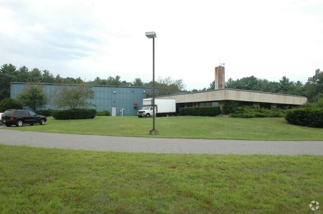

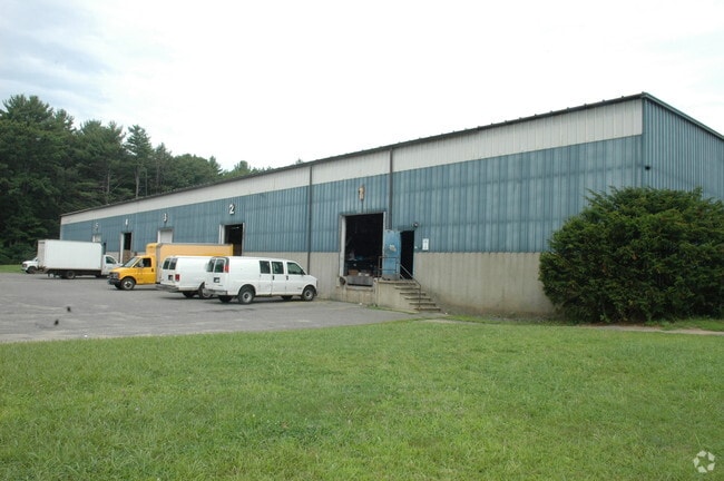
Property Detail
239 Walton Rd
Industrialgeneral
Rockingham
I2
New Hampshire
AE The base floodplain where base flood elevations are provided. AE Zones are now used on new format FIRMs instead of A1-A30 Zones.
23.80 AC
2025
Rockingham
2025
Boston
063003
Boston-Cambridge-Newton, MA-NH
54,859 SF
SEAB-000013-000000-000047
NEARBY LISTINGS FOR SALE OR LEASE
DEMOGRAPHICS near 239 Walton Rd
1 mile
3 mile
5 mile
2025 Total Population
3,358
19,977
57,523
2030 Population
3,413
20,857
59,517
Pop Growth 2025-2030
+ 1.64%
+ 4.41%
+ 3.47%
Average Age
48
48
47
2025 Total Households
1,423
9,018
25,924
HH Growth 2025-2030
+ 1.55%
+ 4.64%
+ 3.62%
Median Household Inc
$87,171
$90,935
$96,774
Avg Household Size
2.30
2.20
2.20
2025 Avg HH Vehicles
2.00
2.00
2.00
Median Home Value
$456,418
$553,957
$604,085
Median Year Built
1991
1980
1974
Nearby Places
Map Layers
Map Styles
 Street
 Aerial
Layers
 Traffic
 Biking
Places
Listings with unknown addresses are not visible on the map
- Restaurants
- Banks
- Shops
- Fitness
- Groceries
PUBLIC TRANSPORTATION
COMMUTER RAIL
Newburyport (Newburyport/Rockport Line - Massachusetts Bay Transportation Authority Commuter Rail (Purple Line))
Drive
Walk
Distance
Newburyport (Newburyport/Rockport Line - Massachusetts Bay Transportation Authority Commuter Rail (Purple Line))
20 min
10.0 mi
AIRPORT
Portsmouth International at Pease
Drive
Walk
Distance
Portsmouth International at Pease
31 min
19.0 mi
Manchester Boston Regional
Drive
Walk
Distance
Manchester Boston Regional
67 min
45.9 mi
Freight Ports
Port of Boston
Drive
Walk
Distance
Port of Boston
64 min
44.8 mi
SALE & LEASE HISTORY
LISTING DATE
SALE/LEASE

Sep 24, 2016
For Sale
Nov 13, 2017
For Lease
Nearby Properties
Address
Land Use
TOTAL SIZE
Lot Size
Zoning
Address
Land Use
TOTAL SIZE
Lot Size
Zoning
4,884 SF
40 AC
RB
Address
Land Use
TOTAL SIZE
Lot Size
Zoning
55,934 SF
35.25 AC
A
Address
Land Use
TOTAL SIZE
Lot Size
Zoning
504,280 SF
80.02 AC
I3
Address
Land Use
TOTAL SIZE
Lot Size
Zoning
267,857 SF
13.10 AC
BC
Address
Land Use
TOTAL SIZE
Lot Size
Zoning
120,362 SF
32.29 AC
LA4
Address
Land Use
TOTAL SIZE
Lot Size
Zoning
112,708 SF
40 AC
50
Address
Land Use
TOTAL SIZE
Lot Size
Zoning
116,112 SF
4.52 AC
BS1
Address
Land Use
TOTAL SIZE
Lot Size
Zoning
143,335 SF
16.72 AC
LA4
Address
Land Use
TOTAL SIZE
Lot Size
Zoning
30,440 SF
17.99 AC
LA4
Address
Land Use
TOTAL SIZE
Lot Size
Zoning
179,840 SF
13.46 AC
LA4
Address
Land Use
TOTAL SIZE
Lot Size
Zoning
Address
Land Use
TOTAL SIZE
Lot Size
Zoning
87,374 SF
21.66 AC
LA3
Address
Land Use
TOTAL SIZE
Lot Size
Zoning
7,936 SF
12.80 AC
A
Address
Land Use
TOTAL SIZE
Lot Size
Zoning
134,617 SF
15.89 AC
LA4
Address
Land Use
TOTAL SIZE
Lot Size
Zoning
101,044 SF
13.24 AC
LA4
Address
Land Use
TOTAL SIZE
Lot Size
Zoning
25,867 SF
9.17 AC
BS
Address
Land Use
TOTAL SIZE
Lot Size
Zoning
116,650 SF
21.07 AC
LA4
Address
Land Use
TOTAL SIZE
Lot Size
Zoning
3,820 SF
9.15 AC
40
Address
Land Use
TOTAL SIZE
Lot Size
Zoning
20,160 SF
4.81 AC
A
Address
Land Use
TOTAL SIZE
Lot Size
Zoning
577.79 AC
I2
Address
Land Use
TOTAL SIZE
Lot Size
Zoning
78,886 SF
75.81 AC
C2
Address
Land Use
TOTAL SIZE
Lot Size
Zoning
106,787 SF
22.25 AC
C
Address
Land Use
TOTAL SIZE
Lot Size
Zoning
139,877 SF
11.09 AC
LA4
Address
Land Use
TOTAL SIZE
Lot Size
Zoning
11,904 SF
7.83 AC
A
Address
Land Use
TOTAL SIZE
Lot Size
Zoning
34,416 SF
11.50 AC
A
Address
Land Use
TOTAL SIZE
Lot Size
Zoning
136,020 SF
8.03 AC
I5
Address
Land Use
TOTAL SIZE
Lot Size
Zoning
Address
Land Use
TOTAL SIZE
Lot Size
Zoning
57,215 SF
4.40 AC
TOWN C
Address
Land Use
TOTAL SIZE
Lot Size
Zoning
21,375 SF
11.80 AC
LA4
Address
Land Use
TOTAL SIZE
Lot Size
Zoning
42,828 SF
4.69 AC
LA2
The World's #1 Commercial Real Estate Marketplace
Connect with us
© 2026 CoStar Group
The information above has been obtained from sources believed reliable. While we do not doubt its accuracy we have not verified it and make no guarantee, warranty or representation about it. It is your responsibility to independently confirm its accuracy and completeness. Any projections, opinions, assumptions, or estimates used are for example only and do not represent the current or future performance of the property. The value of this transaction to you depends on tax and other factors which should be evaluated by your tax, financial, and legal advisors. You and your advisors should conduct a careful, independent investigation of the property to determine to your satisfaction the suitability of the property for your needs.