Property Record
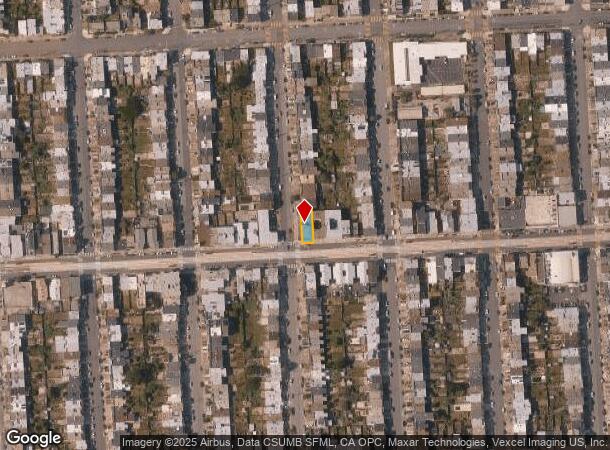
2390 43Rd Ave, San Francisco, CA 94116
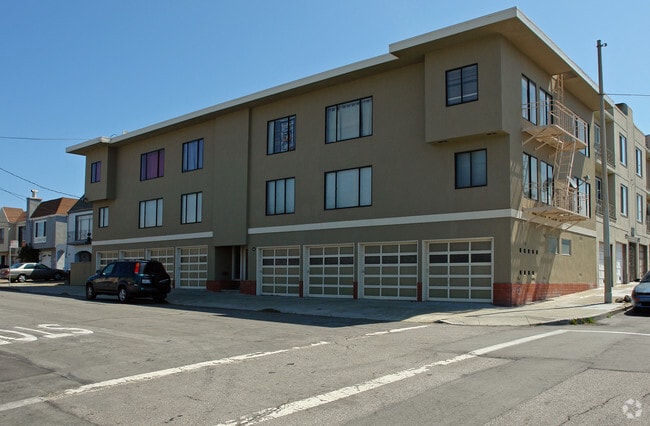

This Property Is For Sale
NEARBY LISTINGS FOR SALE OR LEASE
Property Detail
2390 43Rd Ave
San Francisco-Redwood City-South San Francisco, CA
Outside Land Bl 1144
2371-016
San Francisco
Apartment
California
2024
16
2025
0.08 AC
035300
Outer Sunset
5,730 SF
San Francisco
DEMOGRAPHICS near 2390 43Rd Ave
1 Mile
3 Mile
5 Mile
2024 Total Population
30,228
187,825
561,822
2029 Population
27,379
172,807
519,320
Pop Growth 2024-2029
(9.43%)
(8.00%)
(7.57%)
Average Age
45
44
43
2024 Total Households
10,272
70,464
216,890
HH Growth 2024-2029
(10.01%)
(8.41%)
(7.97%)
Median Household Inc
$131,348
$124,256
$131,373
Avg Household Size
2.90
2.60
2.50
2024 Avg HH Vehicles
2.00
2.00
1.00
Median Home Value
$1,104,977
$1,116,571
$1,099,289
Median Year Built
1947
1948
1948
Nearby Places
- Restaurants
- Banks
- Shops
- Fitness
- Groceries
PUBLIC TRANSPORTATION
TRANSIT/SUBWAY
Taraval St & 42Nd Ave (TARAVAL - San Francisco Municipal Transportation Agency)
DRIVE
WALK
Distance
Taraval St & 42Nd Ave (TARAVAL - San Francisco Municipal Transportation Agency)
0 min
1 min
0.1 mi
Taraval St & 44Th Ave (TARAVAL - San Francisco Municipal Transportation Agency)
DRIVE
WALK
Distance
Taraval St & 44Th Ave (TARAVAL - San Francisco Municipal Transportation Agency)
0 min
1 min
0.1 mi
46Th Ave & Taraval St (TARAVAL - San Francisco Municipal Transportation Agency)
DRIVE
WALK
Distance
46Th Ave & Taraval St (TARAVAL - San Francisco Municipal Transportation Agency)
0 min
3 min
0.2 mi
Taraval St & 40Th Ave (TARAVAL - San Francisco Municipal Transportation Agency)
DRIVE
WALK
Distance
Taraval St & 40Th Ave (TARAVAL - San Francisco Municipal Transportation Agency)
0 min
3 min
0.2 mi
46Th Ave & Ulloa St (TARAVAL - San Francisco Municipal Transportation Agency)
DRIVE
WALK
Distance
46Th Ave & Ulloa St (TARAVAL - San Francisco Municipal Transportation Agency)
1 min
6 min
0.3 mi
COMMUTER RAIL
Bayshore Caltrain Station (Local - Caltrain (Caltrain), Local Weekday - Caltrain (Caltrain), Local Weekend - Caltrain (Caltrain))
DRIVE
WALK
Distance
Bayshore Caltrain Station (Local - Caltrain (Caltrain), Local Weekday - Caltrain (Caltrain), Local Weekend - Caltrain (Caltrain))
16 min
7.7 mi
22Nd Street (Caltrain - Caltrain (Caltrain))
DRIVE
WALK
Distance
22Nd Street (Caltrain - Caltrain (Caltrain))
16 min
8.7 mi
AIRPORT
San Francisco International
DRIVE
WALK
Distance
San Francisco International
24 min
14.1 mi
Metro Oakland International
DRIVE
WALK
Distance
Metro Oakland International
45 min
26.5 mi
Freight Ports
Port of San Francisco
DRIVE
WALK
Distance
Port of San Francisco
21 min
10.9 mi
Nearby Properties
Address
Land Use
TOTAL SIZE
Lot Size
Zoning
Address
Land Use
TOTAL SIZE
Lot Size
Zoning
411,904 SF
21.74 AC
C2
Address
Land Use
TOTAL SIZE
Lot Size
Zoning
2.03 AC
C2
Address
Land Use
TOTAL SIZE
Lot Size
Zoning
88,900 SF
5.37 AC
NCS
Address
Land Use
TOTAL SIZE
Lot Size
Zoning
11.31 AC
RM2
Address
Land Use
TOTAL SIZE
Lot Size
Zoning
160,983 SF
1.84 AC
NC2
Address
Land Use
TOTAL SIZE
Lot Size
Zoning
90,539 SF
2.28 AC
RH2
Address
Land Use
TOTAL SIZE
Lot Size
Zoning
Address
Land Use
TOTAL SIZE
Lot Size
Zoning
73,491 SF
4.48 AC
C2
Address
Land Use
TOTAL SIZE
Lot Size
Zoning
146,036 SF
0.49 AC
RH3
Address
Land Use
TOTAL SIZE
Lot Size
Zoning
176,000 SF
1.64 AC
C2
Address
Land Use
TOTAL SIZE
Lot Size
Zoning
54,131 SF
1.75 AC
C2
Address
Land Use
TOTAL SIZE
Lot Size
Zoning
76,000 SF
1.48 AC
RM4
Address
Land Use
TOTAL SIZE
Lot Size
Zoning
194,477 SF
11.37 AC
RH1
Address
Land Use
TOTAL SIZE
Lot Size
Zoning
205,770 SF
3.37 AC
RM4
Address
Land Use
TOTAL SIZE
Lot Size
Zoning
6.80 AC
RM1
Address
Land Use
TOTAL SIZE
Lot Size
Zoning
81,756 SF
5.39 AC
RH1D
Address
Land Use
TOTAL SIZE
Lot Size
Zoning
2.01 AC
RM1
Address
Land Use
TOTAL SIZE
Lot Size
Zoning
6.18 AC
RM1
Address
Land Use
TOTAL SIZE
Lot Size
Zoning
108,970 SF
7 AC
NCS
Address
Land Use
TOTAL SIZE
Lot Size
Zoning
13,300 SF
6.38 AC
C2
Address
Land Use
TOTAL SIZE
Lot Size
Zoning
52,000 SF
2.32 AC
NCS
Address
Land Use
TOTAL SIZE
Lot Size
Zoning
70,120 SF
6.35 AC
RM2
Address
Land Use
TOTAL SIZE
Lot Size
Zoning
100,000 SF
1.91 AC
RH-1(D)
Address
Land Use
TOTAL SIZE
Lot Size
Zoning
34,253 SF
1.65 AC
NCS
Address
Land Use
TOTAL SIZE
Lot Size
Zoning
4.25 AC
RM1
Address
Land Use
TOTAL SIZE
Lot Size
Zoning
4.25 AC
RM1
Address
Land Use
TOTAL SIZE
Lot Size
Zoning
20,790 SF
0.21 AC
NCT1
Address
Land Use
TOTAL SIZE
Lot Size
Zoning
3.74 AC
RM1
Address
Land Use
TOTAL SIZE
Lot Size
Zoning
61,330 SF
109.60 AC
RH1D
Address
Land Use
TOTAL SIZE
Lot Size
Zoning
32,692 SF
1.65 AC
RH1D
The World's #1 Commercial Real Estate Marketplace
Connect with us
© 2025 CoStar Group
The information above has been obtained from sources believed reliable. While we do not doubt its accuracy we have not verified it and make no guarantee, warranty or representation about it. It is your responsibility to independently confirm its accuracy and completeness. Any projections, opinions, assumptions, or estimates used are for example only and do not represent the current or future performance of the property. The value of this transaction to you depends on tax and other factors which should be evaluated by your tax, financial, and legal advisors. You and your advisors should conduct a careful, independent investigation of the property to determine to your satisfaction the suitability of the property for your needs.