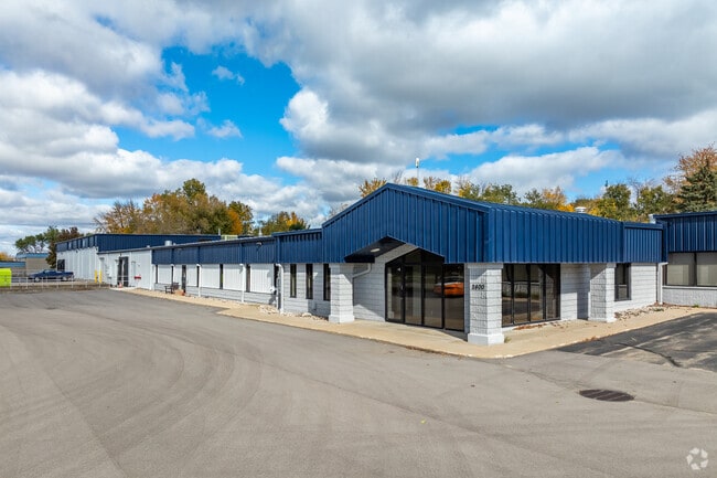
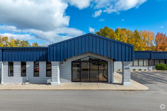
Property Record
2390 Industrial Dr, Neenah, WI 54956

Current Lease Availabilities
NEARBY LISTINGS FOR SALE OR LEASE
Property Detail
2390 Industrial Dr
Oshkosh-Neenah, WI
Certified Surv Map
02-1306-0200
LOT 1 CSM 6653 DOC #1610657
Commercialnec
Winnebago
X
Wisconsin
55087C0450D
1
2023
3.14 AC
2024
Appleton/Oshkosh
003704
Other Market Areas
61,116 SF
DEMOGRAPHICS near 2390 Industrial Dr
1 Mile
3 Mile
5 Mile
2024 Total Population
5,257
29,712
49,442
2029 Population
5,240
29,641
49,386
Pop Growth 2024-2029
(0.32%)
(0.24%)
(0.11%)
Average Age
40
40
40
2024 Total Households
2,265
12,529
20,868
HH Growth 2024-2029
(0.44%)
(0.40%)
(0.27%)
Median Household Inc
$64,000
$70,018
$68,587
Avg Household Size
2.30
2.30
2.30
2024 Avg HH Vehicles
2.00
2.00
2.00
Median Home Value
$198,667
$183,797
$182,335
Median Year Built
1979
1970
1969
Nearby Places
Map Layers
Map Styles
 Street
 Aerial
- Restaurants
- Banks
- Shops
- Fitness
- Groceries
PUBLIC TRANSPORTATION
AIRPORT
Appleton International
DRIVE
WALK
Distance
Appleton International
18 min
10.7 mi
Green Bay/Austin Straubel International
DRIVE
WALK
Distance
Green Bay/Austin Straubel International
48 min
38.6 mi
Freight Ports
Port Milwaukee
DRIVE
WALK
Distance
Port Milwaukee
117 min
99.7 mi
Nearby Properties
Address
Land Use
TOTAL SIZE
Lot Size
Zoning
Address
Land Use
TOTAL SIZE
Lot Size
Zoning
1,975 SF
2.40 AC
M2
Address
Land Use
TOTAL SIZE
Lot Size
Zoning
800 SF
19.84 AC
I1
Address
Land Use
TOTAL SIZE
Lot Size
Zoning
178,750 SF
0.43 AC
C2
Address
Land Use
TOTAL SIZE
Lot Size
Zoning
59,584 SF
12.11 AC
C1
Address
Land Use
TOTAL SIZE
Lot Size
Zoning
103,427 SF
0.56 AC
PDD
Address
Land Use
TOTAL SIZE
Lot Size
Zoning
89,042 SF
2.83 AC
C2
Address
Land Use
TOTAL SIZE
Lot Size
Zoning
89,576 SF
1.03 AC
C2
Address
Land Use
TOTAL SIZE
Lot Size
Zoning
105,852 SF
0.39 AC
PDD
Address
Land Use
TOTAL SIZE
Lot Size
Zoning
67.41 AC
I2
Address
Land Use
TOTAL SIZE
Lot Size
Zoning
29.32 AC
I1
Address
Land Use
TOTAL SIZE
Lot Size
Zoning
210,214 SF
16.44 AC
I1
Address
Land Use
TOTAL SIZE
Lot Size
Zoning
86,455 SF
PDD
Address
Land Use
TOTAL SIZE
Lot Size
Zoning
361,899 SF
18.54 AC
I2
Address
Land Use
TOTAL SIZE
Lot Size
Zoning
74,603 SF
4.96 AC
I1
Address
Land Use
TOTAL SIZE
Lot Size
Zoning
92,030 SF
7.79 AC
I1
Address
Land Use
TOTAL SIZE
Lot Size
Zoning
145,322 SF
11.20 AC
PDD
Address
Land Use
TOTAL SIZE
Lot Size
Zoning
10.13 AC
M2
Address
Land Use
TOTAL SIZE
Lot Size
Zoning
92,039 SF
13.55 AC
I2
Address
Land Use
TOTAL SIZE
Lot Size
Zoning
31,400 SF
0.37 AC
PDD
Address
Land Use
TOTAL SIZE
Lot Size
Zoning
9.27 AC
I1
Address
Land Use
TOTAL SIZE
Lot Size
Zoning
48,933 SF
2.80 AC
PDD
Address
Land Use
TOTAL SIZE
Lot Size
Zoning
22.72 AC
I1
Address
Land Use
TOTAL SIZE
Lot Size
Zoning
80,914 SF
1.30 AC
C2
Address
Land Use
TOTAL SIZE
Lot Size
Zoning
115,151 SF
11.71 AC
PDD
Address
Land Use
TOTAL SIZE
Lot Size
Zoning
37,672 SF
5.26 AC
PDD
Address
Land Use
TOTAL SIZE
Lot Size
Zoning
117,640 SF
7.45 AC
I1
Address
Land Use
TOTAL SIZE
Lot Size
Zoning
10.16 AC
M2
Address
Land Use
TOTAL SIZE
Lot Size
Zoning
160,920 SF
7.98 AC
M2
Address
Land Use
TOTAL SIZE
Lot Size
Zoning
160,920 SF
7.89 AC
M2
Address
Land Use
TOTAL SIZE
Lot Size
Zoning
71,538 SF
2.67 AC
CH
The World's #1 Commercial Real Estate Marketplace
Connect with us
© 2026 CoStar Group
The information above has been obtained from sources believed reliable. While we do not doubt its accuracy we have not verified it and make no guarantee, warranty or representation about it. It is your responsibility to independently confirm its accuracy and completeness. Any projections, opinions, assumptions, or estimates used are for example only and do not represent the current or future performance of the property. The value of this transaction to you depends on tax and other factors which should be evaluated by your tax, financial, and legal advisors. You and your advisors should conduct a careful, independent investigation of the property to determine to your satisfaction the suitability of the property for your needs.