Property Record
23908 Interstate 30 N, Bryant, AR 72022


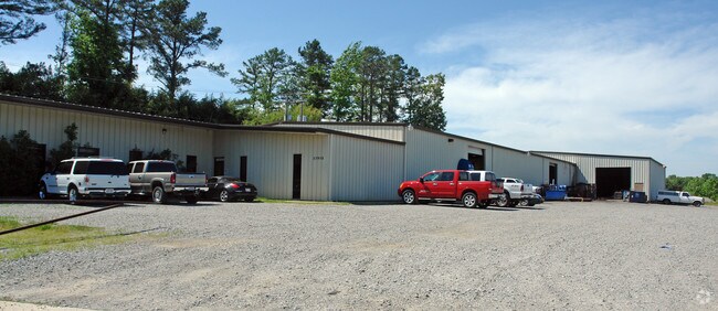
Property Detail
23908 Interstate 30 N
840-12201-000
PT W/2 NENE 2020-015604
Lightindustrial
Saline
B and X Area of moderate flood hazard, usually the area between the limits of the 100-year and 500-year floods.
Arkansas
2025
4.28 AC
2025
Saline County
010411
Little Rock/N Little Rock
5,760 SF
Little Rock-North Little Rock-Conway, AR
NEARBY LISTINGS FOR SALE OR LEASE
-
-
View all Bryant listings for sale on LoopNet.com
DEMOGRAPHICS near 23908 Interstate 30 N
1 mile
3 mile
5 mile
2025 Total Population
4,173
31,694
61,686
2030 Population
4,399
33,330
64,282
Pop Growth 2025-2030
+ 5.42%
+ 5.16%
+ 4.21%
Average Age
40
39
39
2025 Total Households
1,630
12,240
24,373
HH Growth 2025-2030
+ 5.58%
+ 5.16%
+ 4.13%
Median Household Inc
$97,072
$83,251
$75,617
Avg Household Size
2.50
2.50
2.50
2025 Avg HH Vehicles
2.00
2.00
2.00
Median Home Value
$252,367
$246,497
$245,714
Median Year Built
1997
1999
2000
Nearby Places
Map Layers
Map Styles
 Street
 Aerial
Transit
 Traffic
 Biking
Places
Listings with unknown addresses are not visible on the map
- Restaurants
- Banks
- Shops
- Fitness
- Groceries
PUBLIC TRANSPORTATION
AIRPORT
Bill and Hillary Clinton Ntl/Adams Field
Drive
Walk
Distance
Bill and Hillary Clinton Ntl/Adams Field
26 min
20.2 mi
Freight Ports
Port of Shreveport
Drive
Walk
Distance
Port of Shreveport
232 min
217.1 mi
Nearby Properties
Address
Land Use
TOTAL SIZE
Lot Size
Zoning
Address
Land Use
TOTAL SIZE
Lot Size
Zoning
80,480 SF
33.40 AC
Address
Land Use
TOTAL SIZE
Lot Size
Zoning
91,459 SF
6.03 AC
Address
Land Use
TOTAL SIZE
Lot Size
Zoning
28,150 SF
17.11 AC
Address
Land Use
TOTAL SIZE
Lot Size
Zoning
304,000 SF
20.93 AC
Address
Land Use
TOTAL SIZE
Lot Size
Zoning
262,431 SF
23.01 AC
Address
Land Use
TOTAL SIZE
Lot Size
Zoning
121,010 SF
13.33 AC
Address
Land Use
TOTAL SIZE
Lot Size
Zoning
174,460 SF
19.30 AC
Address
Land Use
TOTAL SIZE
Lot Size
Zoning
138,752 SF
12.60 AC
Address
Land Use
TOTAL SIZE
Lot Size
Zoning
139,990 SF
14.40 AC
Address
Land Use
TOTAL SIZE
Lot Size
Zoning
72,506 SF
4.44 AC
Address
Land Use
TOTAL SIZE
Lot Size
Zoning
19,208 SF
12 AC
Address
Land Use
TOTAL SIZE
Lot Size
Zoning
10,050 SF
94.63 AC
Address
Land Use
TOTAL SIZE
Lot Size
Zoning
36,356 SF
5.45 AC
Address
Land Use
TOTAL SIZE
Lot Size
Zoning
61,535 SF
10.99 AC
Address
Land Use
TOTAL SIZE
Lot Size
Zoning
44,776 SF
7 AC
Address
Land Use
TOTAL SIZE
Lot Size
Zoning
44,132 SF
8.31 AC
Address
Land Use
TOTAL SIZE
Lot Size
Zoning
6,715 SF
2.95 AC
Address
Land Use
TOTAL SIZE
Lot Size
Zoning
48,067 SF
17.18 AC
Address
Land Use
TOTAL SIZE
Lot Size
Zoning
49,216 SF
4.30 AC
Address
Land Use
TOTAL SIZE
Lot Size
Zoning
54.01 AC
Address
Land Use
TOTAL SIZE
Lot Size
Zoning
15,192 SF
8.96 AC
Address
Land Use
TOTAL SIZE
Lot Size
Zoning
13,612 SF
9.91 AC
Address
Land Use
TOTAL SIZE
Lot Size
Zoning
47,468 SF
1.57 AC
Address
Land Use
TOTAL SIZE
Lot Size
Zoning
75,000 SF
3.70 AC
Address
Land Use
TOTAL SIZE
Lot Size
Zoning
24,000 SF
3.31 AC
Address
Land Use
TOTAL SIZE
Lot Size
Zoning
37,119 SF
2.26 AC
Address
Land Use
TOTAL SIZE
Lot Size
Zoning
46,420 SF
1.50 AC
Address
Land Use
TOTAL SIZE
Lot Size
Zoning
14,668 SF
1.62 AC
Address
Land Use
TOTAL SIZE
Lot Size
Zoning
20,820 SF
2.89 AC
Address
Land Use
TOTAL SIZE
Lot Size
Zoning
44,304 SF
3.40 AC
The World's #1 Commercial Real Estate Marketplace
Connect with us
© 2026 CoStar Group
The information above has been obtained from sources believed reliable. While we do not doubt its accuracy we have not verified it and make no guarantee, warranty or representation about it. It is your responsibility to independently confirm its accuracy and completeness. Any projections, opinions, assumptions, or estimates used are for example only and do not represent the current or future performance of the property. The value of this transaction to you depends on tax and other factors which should be evaluated by your tax, financial, and legal advisors. You and your advisors should conduct a careful, independent investigation of the property to determine to your satisfaction the suitability of the property for your needs.