Property Record
24 3Rd St, Palmer, MA 01069
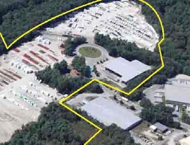

Property Detail
24 3Rd St
Manufacturinglight
Hampden
URIP
Massachusetts
AE The base floodplain where base flood elevations are provided. AE Zones are now used on new format FIRMs instead of A1-A30 Zones.
4.30 AC
2025
Hampden County
2025
Hartford
810200
Springfield, MA
41,076 SF
PALM-000028-000000-000034
NEARBY LISTINGS FOR SALE OR LEASE
-
-
View all Palmer listings for sale on LoopNet.com
DEMOGRAPHICS near 24 3Rd St
1 mile
3 mile
5 mile
2025 Total Population
1,402
10,981
25,378
2030 Population
1,403
10,989
25,444
Pop Growth 2025-2030
+ 0.07%
+ 0.07%
+ 0.26%
Average Age
41
43
44
2025 Total Households
523
4,537
10,452
HH Growth 2025-2030
+ 0.19%
+ 0.13%
+ 0.37%
Median Household Inc
$93,260
$85,276
$87,516
Avg Household Size
2.60
2.40
2.40
2025 Avg HH Vehicles
2.00
2.00
2.00
Median Home Value
$341,544
$316,172
$336,671
Median Year Built
1976
1970
1973
Nearby Places
Map Layers
Map Styles
 Street
 Aerial
Transit
 Traffic
 Biking
Places
Listings with unknown addresses are not visible on the map
- Restaurants
- Banks
- Shops
- Fitness
- Groceries
PUBLIC TRANSPORTATION
AIRPORT
Bradley International
Drive
Walk
Distance
Bradley International
63 min
30.8 mi
Worcester Regional
Drive
Walk
Distance
Worcester Regional
62 min
40.6 mi
Freight Ports
Port of Davisville, RI
Drive
Walk
Distance
Port of Davisville, RI
120 min
91.9 mi
The World's #1 Commercial Real Estate Marketplace
Connect with us
© 2026 CoStar Group
The information above has been obtained from sources believed reliable. While we do not doubt its accuracy we have not verified it and make no guarantee, warranty or representation about it. It is your responsibility to independently confirm its accuracy and completeness. Any projections, opinions, assumptions, or estimates used are for example only and do not represent the current or future performance of the property. The value of this transaction to you depends on tax and other factors which should be evaluated by your tax, financial, and legal advisors. You and your advisors should conduct a careful, independent investigation of the property to determine to your satisfaction the suitability of the property for your needs.