Property Record
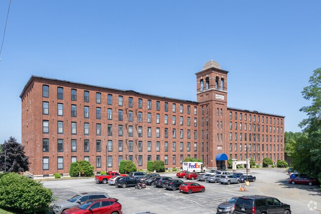
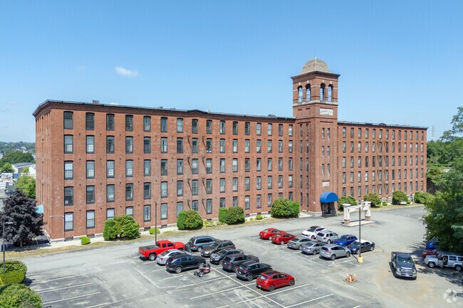
24 Bradley Ct, Fall River, MA 02720

Property Detail
24 Bradley Ct
FALL-000003T-000000-000001
Bristol
Apartment
Massachusetts
IND
1
C and X Area of minimal flood hazard, usually depicted on FIRMs as above the 500-year flood level.
4.07 AC
2025
Western Fall River
2025
Boston
642300
Providence-Warwick, RI-MA
136,814 SF
NEARBY LISTINGS FOR SALE OR LEASE
DEMOGRAPHICS near 24 Bradley Ct
1 mile
3 mile
5 mile
2025 Total Population
13,032
87,073
134,476
2030 Population
13,297
88,787
136,628
Pop Growth 2025-2030
+ 2.03%
+ 1.97%
+ 1.60%
Average Age
43
41
41
2025 Total Households
5,516
37,719
57,316
HH Growth 2025-2030
+ 2.12%
+ 2.06%
+ 1.68%
Median Household Inc
$70,697
$61,725
$65,110
Avg Household Size
2.20
2.20
2.30
2025 Avg HH Vehicles
2.00
1.00
2.00
Median Home Value
$430,374
$403,560
$414,044
Median Year Built
1948
1949
1951
Nearby Places
Map Layers
Map Styles
 Street
 Aerial
Transit
 Traffic
 Biking
Places
Listings with unknown addresses are not visible on the map
- Restaurants
- Banks
- Shops
- Fitness
- Groceries
PUBLIC TRANSPORTATION
AIRPORT
Rhode Island Tf Green International
Drive
Walk
Distance
Rhode Island Tf Green International
40 min
24.4 mi
Freight Ports
Port of New Bedford Harbor
Drive
Walk
Distance
Port of New Bedford Harbor
25 min
17.0 mi
Nearby Properties
Address
Land Use
TOTAL SIZE
Lot Size
Zoning
Address
Land Use
TOTAL SIZE
Lot Size
Zoning
634,182 SF
63.86 AC
N/A
Address
Land Use
TOTAL SIZE
Lot Size
Zoning
226,473 SF
29.10 AC
R1
Address
Land Use
TOTAL SIZE
Lot Size
Zoning
203,989 SF
2.01 AC
A-2
Address
Land Use
TOTAL SIZE
Lot Size
Zoning
14.30 AC
G
Address
Land Use
TOTAL SIZE
Lot Size
Zoning
212,639 SF
22.75 AC
S
Address
Land Use
TOTAL SIZE
Lot Size
Zoning
0.06 AC
A-2
Address
Land Use
TOTAL SIZE
Lot Size
Zoning
118,979 SF
6.65 AC
M
Address
Land Use
TOTAL SIZE
Lot Size
Zoning
90.84 AC
N/A
Address
Land Use
TOTAL SIZE
Lot Size
Zoning
115,119 SF
151.54 AC
WR
Address
Land Use
TOTAL SIZE
Lot Size
Zoning
140,946 SF
8.24 AC
S
Address
Land Use
TOTAL SIZE
Lot Size
Zoning
599,760 SF
33.60 AC
INPK
Address
Land Use
TOTAL SIZE
Lot Size
Zoning
105,949 SF
25.21 AC
R1
Address
Land Use
TOTAL SIZE
Lot Size
Zoning
17.18 AC
IND
Address
Land Use
TOTAL SIZE
Lot Size
Zoning
53.87 AC
N/A
Address
Land Use
TOTAL SIZE
Lot Size
Zoning
136,622 SF
55.54 AC
S
Address
Land Use
TOTAL SIZE
Lot Size
Zoning
10 AC
B
Address
Land Use
TOTAL SIZE
Lot Size
Zoning
126,146 SF
1.18 AC
A-2
Address
Land Use
TOTAL SIZE
Lot Size
Zoning
18.65 AC
A-2
Address
Land Use
TOTAL SIZE
Lot Size
Zoning
3,016 SF
16.79 AC
M
Address
Land Use
TOTAL SIZE
Lot Size
Zoning
85,692 SF
4.05 AC
S
Address
Land Use
TOTAL SIZE
Lot Size
Zoning
255,600 SF
12.46 AC
R4
Address
Land Use
TOTAL SIZE
Lot Size
Zoning
28,438 SF
245 AC
C
Address
Land Use
TOTAL SIZE
Lot Size
Zoning
497,656 SF
30.47 AC
INPK
Address
Land Use
TOTAL SIZE
Lot Size
Zoning
177,051 SF
3.13 AC
CBD
Address
Land Use
TOTAL SIZE
Lot Size
Zoning
808 AC
WR
Address
Land Use
TOTAL SIZE
Lot Size
Zoning
160,234 SF
2.98 AC
CBD
Address
Land Use
TOTAL SIZE
Lot Size
Zoning
75,736 SF
1.39 AC
B-L
Address
Land Use
TOTAL SIZE
Lot Size
Zoning
26.51 AC
G
Address
Land Use
TOTAL SIZE
Lot Size
Zoning
3,150 SF
7.91 AC
S
Address
Land Use
TOTAL SIZE
Lot Size
Zoning
131,086 SF
2.29 AC
CBD
The World's #1 Commercial Real Estate Marketplace
Connect with us
© 2026 CoStar Group
The information above has been obtained from sources believed reliable. While we do not doubt its accuracy we have not verified it and make no guarantee, warranty or representation about it. It is your responsibility to independently confirm its accuracy and completeness. Any projections, opinions, assumptions, or estimates used are for example only and do not represent the current or future performance of the property. The value of this transaction to you depends on tax and other factors which should be evaluated by your tax, financial, and legal advisors. You and your advisors should conduct a careful, independent investigation of the property to determine to your satisfaction the suitability of the property for your needs.