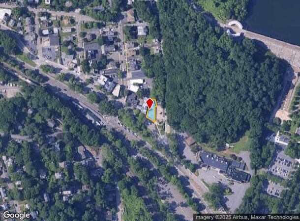
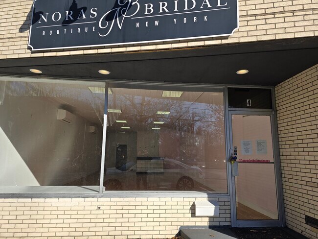
Property Record
24 Broadway, Valhalla, NY 10595

NEARBY LISTINGS FOR SALE OR LEASE
Property Detail
24 Broadway
3489-117-019-00002-035-0000
Map Of Lake Kensico Park
Commercialofficeresidentialmixeduse
Westchester
X
New York
36119C0259F
35.000
2025
0.12 AC
2024
West I-287 Corridor
011902
Westchester/So Connecticut
6,849 SF
New York-Jersey City-White Plains, NY-NJ
DEMOGRAPHICS near 24 Broadway
1 Mile
3 Mile
5 Mile
2024 Total Population
4,896
70,109
173,994
2029 Population
4,721
68,824
171,438
Pop Growth 2024-2029
(3.57%)
(1.83%)
(1.47%)
Average Age
42
42
42
2024 Total Households
1,810
27,183
64,712
HH Growth 2024-2029
(3.76%)
(1.75%)
(1.54%)
Median Household Inc
$135,480
$117,828
$127,261
Avg Household Size
2.70
2.40
2.50
2024 Avg HH Vehicles
2.00
2.00
2.00
Median Home Value
$651,825
$607,575
$676,074
Median Year Built
1956
1963
1960
Nearby Places
Map Layers
Map Styles
 Street
 Aerial
- Restaurants
- Banks
- Shops
- Fitness
- Groceries
PUBLIC TRANSPORTATION
TRANSIT/SUBWAY
Valhalla Station (Harlem Line - Metro-North Commuter Railroad Company (Metro-North))
DRIVE
WALK
Distance
Valhalla Station (Harlem Line - Metro-North Commuter Railroad Company (Metro-North))
3 min
3 min
0.2 mi
COMMUTER RAIL
Valhalla Station (Harlem Line - Metro-North Commuter Railroad Company (Metro-North))
DRIVE
WALK
Distance
Valhalla Station (Harlem Line - Metro-North Commuter Railroad Company (Metro-North))
3 min
3 min
0.2 mi
North White Plains Station (Harlem Line - Metro-North Commuter Railroad Company (Metro-North))
DRIVE
WALK
Distance
North White Plains Station (Harlem Line - Metro-North Commuter Railroad Company (Metro-North))
4 min
2.0 mi
AIRPORT
Westchester County
DRIVE
WALK
Distance
Westchester County
13 min
7.5 mi
LaGuardia
DRIVE
WALK
Distance
LaGuardia
45 min
30.6 mi
John F Kennedy International
DRIVE
WALK
Distance
John F Kennedy International
53 min
35.8 mi
Freight Ports
NY - Red Hook Container Terminal
DRIVE
WALK
Distance
NY - Red Hook Container Terminal
58 min
38.7 mi
SALE & LEASE HISTORY
LISTING DATE
SALE/LEASE

Nov 30, 2023
For Lease
Jun 22, 2023
For Lease
Jun 22, 2023
For Lease
Dec 05, 2024
For Lease
Aug 17, 2019
For Lease
Nearby Properties
Address
Land Use
TOTAL SIZE
Lot Size
Zoning
Address
Land Use
TOTAL SIZE
Lot Size
Zoning
358.83 AC
Address
Land Use
TOTAL SIZE
Lot Size
Zoning
4.45 AC
B
Address
Land Use
TOTAL SIZE
Lot Size
Zoning
2,760 SF
60.76 AC
Address
Land Use
TOTAL SIZE
Lot Size
Zoning
75.87 AC
R-20
Address
Land Use
TOTAL SIZE
Lot Size
Zoning
17.17 AC
Address
Land Use
TOTAL SIZE
Lot Size
Zoning
24.66 AC
Address
Land Use
TOTAL SIZE
Lot Size
Zoning
16.22 AC
UR
Address
Land Use
TOTAL SIZE
Lot Size
Zoning
19.25 AC
Address
Land Use
TOTAL SIZE
Lot Size
Zoning
60.01 AC
Address
Land Use
TOTAL SIZE
Lot Size
Zoning
11.61 AC
Address
Land Use
TOTAL SIZE
Lot Size
Zoning
Address
Land Use
TOTAL SIZE
Lot Size
Zoning
68,000 SF
1.53 AC
B
Address
Land Use
TOTAL SIZE
Lot Size
Zoning
Address
Land Use
TOTAL SIZE
Lot Size
Zoning
29.42 AC
PUD
Address
Land Use
TOTAL SIZE
Lot Size
Zoning
10.90 AC
UR
Address
Land Use
TOTAL SIZE
Lot Size
Zoning
Address
Land Use
TOTAL SIZE
Lot Size
Zoning
180,750 SF
22.03 AC
PD
Address
Land Use
TOTAL SIZE
Lot Size
Zoning
3.16 AC
Address
Land Use
TOTAL SIZE
Lot Size
Zoning
7.98 AC
M-14
Address
Land Use
TOTAL SIZE
Lot Size
Zoning
0.58 AC
B
Address
Land Use
TOTAL SIZE
Lot Size
Zoning
39.83 AC
Address
Land Use
TOTAL SIZE
Lot Size
Zoning
50,000 SF
9.02 AC
PD
Address
Land Use
TOTAL SIZE
Lot Size
Zoning
96,560 SF
12.76 AC
DS
Address
Land Use
TOTAL SIZE
Lot Size
Zoning
29.14 AC
PUD
Address
Land Use
TOTAL SIZE
Lot Size
Zoning
15.96 AC
OB
Address
Land Use
TOTAL SIZE
Lot Size
Zoning
3.56 AC
PD
Address
Land Use
TOTAL SIZE
Lot Size
Zoning
84,450 SF
3.19 AC
B
Address
Land Use
TOTAL SIZE
Lot Size
Zoning
100,000 SF
7.21 AC
PD
Address
Land Use
TOTAL SIZE
Lot Size
Zoning
5.43 AC
R-40
Address
Land Use
TOTAL SIZE
Lot Size
Zoning
320 SF
5.38 AC
LI
The World's #1 Commercial Real Estate Marketplace
Connect with us
© 2026 CoStar Group
The information above has been obtained from sources believed reliable. While we do not doubt its accuracy we have not verified it and make no guarantee, warranty or representation about it. It is your responsibility to independently confirm its accuracy and completeness. Any projections, opinions, assumptions, or estimates used are for example only and do not represent the current or future performance of the property. The value of this transaction to you depends on tax and other factors which should be evaluated by your tax, financial, and legal advisors. You and your advisors should conduct a careful, independent investigation of the property to determine to your satisfaction the suitability of the property for your needs.