Property Record
24 Brook Rd, Amherst, NH 03031
This Property Is For Sale
NEARBY LISTINGS FOR SALE OR LEASE
Property Detail
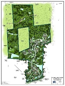
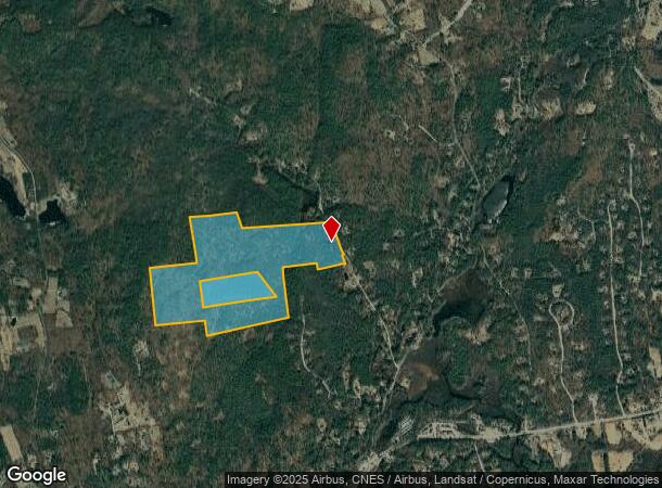
24 Brook Rd
Sfr
Hillsborough
AE
New Hampshire
33011C0361D
127.30 AC
2024
Hillsborough
2024
Boston
015200
Manchester-Nashua, NH
722 SF
AMHS-000010-000026
DEMOGRAPHICS near 24 Brook Rd
1 mile
3 mile
5 mile
2024 Total Population
405
8,043
27,565
2029 Population
415
8,265
28,214
Pop Growth 2024-2029
+ 2.47%
+ 2.76%
+ 2.35%
Average Age
43
42
41
2024 Total Households
136
2,755
9,466
HH Growth 2024-2029
+ 2.94%
+ 2.83%
+ 2.36%
Median Household Inc
$164,394
$153,376
$149,189
Avg Household Size
2.80
2.90
2.90
2024 Avg HH Vehicles
3.00
2.00
2.00
Median Home Value
$559,028
$498,863
$496,882
Median Year Built
1979
1979
1984
Nearby Places
Map Layers
Map Styles
 Street
 Aerial
Transit
 Traffic
 Biking
Places
Listings with unknown addresses are not visible on the map
- Restaurants
- Banks
- Shops
- Fitness
- Groceries
PUBLIC TRANSPORTATION
AIRPORT
Manchester Boston Regional
Drive
Walk
Distance
Manchester Boston Regional
28 min
13.8 mi
Freight Ports
Port of Boston
Drive
Walk
Distance
Port of Boston
94 min
64.2 mi
Nearby Properties
Address
Land Use
TOTAL SIZE
Lot Size
Zoning
Address
Land Use
TOTAL SIZE
Lot Size
Zoning
38,993 SF
1,637.30 AC
FCD
Address
Land Use
TOTAL SIZE
Lot Size
Zoning
8,317 SF
7.04 AC
RA
Address
Land Use
TOTAL SIZE
Lot Size
Zoning
9,631 SF
11.25 AC
RR
Address
Land Use
TOTAL SIZE
Lot Size
Zoning
53,714 SF
32.22 AC
LC
Address
Land Use
TOTAL SIZE
Lot Size
Zoning
6,168 SF
4.25 AC
RA
Address
Land Use
TOTAL SIZE
Lot Size
Zoning
6,584 SF
1.59 AC
RA
Address
Land Use
TOTAL SIZE
Lot Size
Zoning
193.77 AC
RA
Address
Land Use
TOTAL SIZE
Lot Size
Zoning
7,586 SF
12 AC
NT
Address
Land Use
TOTAL SIZE
Lot Size
Zoning
665 AC
NR
Address
Land Use
TOTAL SIZE
Lot Size
Zoning
4,250 SF
4.04 AC
RA
Address
Land Use
TOTAL SIZE
Lot Size
Zoning
7,292 SF
13.21 AC
NR
Address
Land Use
TOTAL SIZE
Lot Size
Zoning
7,040 SF
21.62 AC
NR
Address
Land Use
TOTAL SIZE
Lot Size
Zoning
4,342 SF
4.15 AC
RA
Address
Land Use
TOTAL SIZE
Lot Size
Zoning
8,320 SF
5.35 AC
NR
Address
Land Use
TOTAL SIZE
Lot Size
Zoning
4,748 SF
2.90 AC
RA
Address
Land Use
TOTAL SIZE
Lot Size
Zoning
6,290 SF
5 AC
RA
Address
Land Use
TOTAL SIZE
Lot Size
Zoning
6,196 SF
47 AC
NR
Address
Land Use
TOTAL SIZE
Lot Size
Zoning
4,488 SF
5.01 AC
RA
Address
Land Use
TOTAL SIZE
Lot Size
Zoning
4,784 SF
1.49 AC
RA
Address
Land Use
TOTAL SIZE
Lot Size
Zoning
3,979 SF
1.40 AC
RR
Address
Land Use
TOTAL SIZE
Lot Size
Zoning
5,556 SF
9.52 AC
NR
Address
Land Use
TOTAL SIZE
Lot Size
Zoning
4,204 SF
2.63 AC
RA
Address
Land Use
TOTAL SIZE
Lot Size
Zoning
5,447 SF
1.50 AC
RA
Address
Land Use
TOTAL SIZE
Lot Size
Zoning
7,824 SF
37.34 AC
RR
Address
Land Use
TOTAL SIZE
Lot Size
Zoning
19,835 SF
14.80 AC
NT
Address
Land Use
TOTAL SIZE
Lot Size
Zoning
3,606 SF
2.91 AC
RA
Address
Land Use
TOTAL SIZE
Lot Size
Zoning
4,849 SF
19.90 AC
NR
Address
Land Use
TOTAL SIZE
Lot Size
Zoning
6,167 SF
1 AC
RR
Address
Land Use
TOTAL SIZE
Lot Size
Zoning
3,617 SF
2.05 AC
RESIDE
Address
Land Use
TOTAL SIZE
Lot Size
Zoning
5,598 SF
2.18 AC
RA
The World's #1 Commercial Real Estate Marketplace
Connect with us
© 2026 CoStar Group
The information above has been obtained from sources believed reliable. While we do not doubt its accuracy we have not verified it and make no guarantee, warranty or representation about it. It is your responsibility to independently confirm its accuracy and completeness. Any projections, opinions, assumptions, or estimates used are for example only and do not represent the current or future performance of the property. The value of this transaction to you depends on tax and other factors which should be evaluated by your tax, financial, and legal advisors. You and your advisors should conduct a careful, independent investigation of the property to determine to your satisfaction the suitability of the property for your needs.