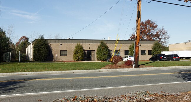
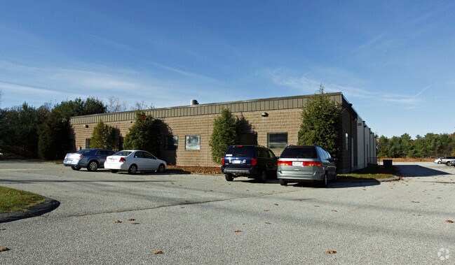
Property Record
24 Cook St, Billerica, MA 01821


Property Detail
24 Cook St
BILL-000090-000230-000002
Middlesex
Manufacturinglight
Massachusetts
5
2
B and X Area of moderate flood hazard, usually the area between the limits of the 100-year and 500-year floods.
2 AC
2025
Lowell/Chelmsford
2025
Boston
316201
Boston-Cambridge-Newton, MA-NH
23,000 SF
NEARBY LISTINGS FOR SALE OR LEASE
DEMOGRAPHICS near 24 Cook St
1 mile
3 mile
5 mile
2025 Total Population
7,295
57,872
142,856
2030 Population
7,527
59,934
148,335
Pop Growth 2025-2030
+ 3.18%
+ 3.56%
+ 3.84%
Average Age
42
43
43
2025 Total Households
2,445
20,447
52,298
HH Growth 2025-2030
+ 3.23%
+ 3.69%
+ 4.00%
Median Household Inc
$136,390
$144,786
$139,020
Avg Household Size
2.90
2.80
2.60
2025 Avg HH Vehicles
2.00
2.00
2.00
Median Home Value
$670,567
$710,528
$715,437
Median Year Built
1969
1971
1973
Nearby Places
Map Layers
Map Styles
 Street
 Aerial
Layers
 Traffic
 Biking
Places
Listings with unknown addresses are not visible on the map
- Restaurants
- Banks
- Shops
- Fitness
- Groceries
PUBLIC TRANSPORTATION
COMMUTER RAIL
Wilmington (Lowell Line - Massachusetts Bay Transportation Authority Commuter Rail (Purple Line))
Drive
Walk
Distance
Wilmington (Lowell Line - Massachusetts Bay Transportation Authority Commuter Rail (Purple Line))
9 min
3.8 mi
North Wilmington (Haverhill Line - Massachusetts Bay Transportation Authority Commuter Rail (Purple Line))
Drive
Walk
Distance
North Wilmington (Haverhill Line - Massachusetts Bay Transportation Authority Commuter Rail (Purple Line))
12 min
5.5 mi
AIRPORT
General Edward Lawrence Logan International
Drive
Walk
Distance
General Edward Lawrence Logan International
34 min
21.1 mi
Manchester Boston Regional
Drive
Walk
Distance
Manchester Boston Regional
58 min
38.0 mi
Nearby Properties
Address
Land Use
TOTAL SIZE
Lot Size
Zoning
Address
Land Use
TOTAL SIZE
Lot Size
Zoning
72,799 SF
69.22 AC
IND
Address
Land Use
TOTAL SIZE
Lot Size
Zoning
135,300 SF
30.85 AC
PD
Address
Land Use
TOTAL SIZE
Lot Size
Zoning
35.90 AC
5
Address
Land Use
TOTAL SIZE
Lot Size
Zoning
253,078 SF
4.18 AC
5
Address
Land Use
TOTAL SIZE
Lot Size
Zoning
32.07 AC
PD
Address
Land Use
TOTAL SIZE
Lot Size
Zoning
325,799 SF
21.70 AC
IND
Address
Land Use
TOTAL SIZE
Lot Size
Zoning
225,792 SF
9.90 AC
4
Address
Land Use
TOTAL SIZE
Lot Size
Zoning
9.50 AC
Address
Land Use
TOTAL SIZE
Lot Size
Zoning
275,751 SF
41.30 AC
R20
Address
Land Use
TOTAL SIZE
Lot Size
Zoning
27.48 AC
5
Address
Land Use
TOTAL SIZE
Lot Size
Zoning
504,154 SF
19.40 AC
2
Address
Land Use
TOTAL SIZE
Lot Size
Zoning
20,382 SF
11.61 AC
IND
Address
Land Use
TOTAL SIZE
Lot Size
Zoning
244,756 SF
15.91 AC
5
Address
Land Use
TOTAL SIZE
Lot Size
Zoning
102,899 SF
28.88 AC
IND
Address
Land Use
TOTAL SIZE
Lot Size
Zoning
16.63 AC
2
Address
Land Use
TOTAL SIZE
Lot Size
Zoning
30,578 SF
13.22 AC
R
Address
Land Use
TOTAL SIZE
Lot Size
Zoning
110,162 SF
16.67 AC
5
Address
Land Use
TOTAL SIZE
Lot Size
Zoning
6.36 AC
5
Address
Land Use
TOTAL SIZE
Lot Size
Zoning
264,936 SF
23.16 AC
IND
Address
Land Use
TOTAL SIZE
Lot Size
Zoning
44,528 SF
23.01 AC
IND
Address
Land Use
TOTAL SIZE
Lot Size
Zoning
188,042 SF
32.31 AC
COM
Address
Land Use
TOTAL SIZE
Lot Size
Zoning
85,490 SF
59.36 AC
A
Address
Land Use
TOTAL SIZE
Lot Size
Zoning
91.75 AC
3
Address
Land Use
TOTAL SIZE
Lot Size
Zoning
88,000 SF
4.86 AC
Address
Land Use
TOTAL SIZE
Lot Size
Zoning
130,720 SF
10.71 AC
COM
Address
Land Use
TOTAL SIZE
Lot Size
Zoning
145,745 SF
11.54 AC
GI
Address
Land Use
TOTAL SIZE
Lot Size
Zoning
130,494 SF
8.35 AC
PD
Address
Land Use
TOTAL SIZE
Lot Size
Zoning
63,963 SF
4.03 AC
5
Address
Land Use
TOTAL SIZE
Lot Size
Zoning
28.58 AC
4
The World's #1 Commercial Real Estate Marketplace
Connect with us
© 2026 CoStar Group
The information above has been obtained from sources believed reliable. While we do not doubt its accuracy we have not verified it and make no guarantee, warranty or representation about it. It is your responsibility to independently confirm its accuracy and completeness. Any projections, opinions, assumptions, or estimates used are for example only and do not represent the current or future performance of the property. The value of this transaction to you depends on tax and other factors which should be evaluated by your tax, financial, and legal advisors. You and your advisors should conduct a careful, independent investigation of the property to determine to your satisfaction the suitability of the property for your needs.