Property Record
24 E Aurora St, Waterbury, CT 06708
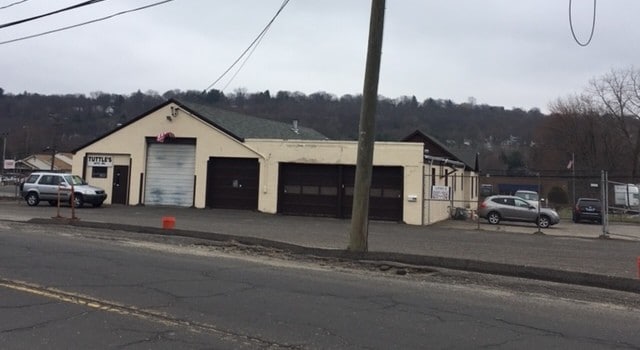

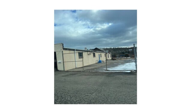
This Property Is For Sale
Property Detail
24 E Aurora St
WATE-000129-000865-000006
Naugatuck Vly
Warehouse
Connecticut
IG
6
B and X Area of moderate flood hazard, usually the area between the limits of the 100-year and 500-year floods.
0.76 AC
2024
Waterbury
2025
Westchester/So Connecticut
352300
New Haven, CT
6,738 SF
NEARBY LISTINGS FOR SALE OR LEASE
DEMOGRAPHICS near 24 E Aurora St
1 mile
3 mile
5 mile
2025 Total Population
13,946
91,637
156,419
2030 Population
14,225
93,768
160,163
Pop Growth 2025-2030
+ 2.00%
+ 2.33%
+ 2.39%
Average Age
36
38
40
2025 Total Households
4,863
35,393
61,041
HH Growth 2025-2030
+ 1.93%
+ 2.42%
+ 2.44%
Median Household Inc
$49,989
$50,418
$61,381
Avg Household Size
2.80
2.50
2.50
2025 Avg HH Vehicles
2.00
1.00
2.00
Median Home Value
$202,515
$224,363
$248,501
Median Year Built
1952
1956
1961
Nearby Places
Map Layers
Map Styles
 Street
 Aerial
Transit
 Traffic
 Biking
Places
Listings with unknown addresses are not visible on the map
- Restaurants
- Banks
- Shops
- Fitness
- Groceries
PUBLIC TRANSPORTATION
COMMUTER RAIL
Waterbury Station (New Haven Line - Metro-North Commuter Railroad Company (Metro-North))
Drive
Walk
Distance
Waterbury Station (New Haven Line - Metro-North Commuter Railroad Company (Metro-North))
6 min
3.4 mi
Naugatuck Station (New Haven Line - Metro-North Commuter Railroad Company (Metro-North))
Drive
Walk
Distance
Naugatuck Station (New Haven Line - Metro-North Commuter Railroad Company (Metro-North))
9 min
7.5 mi
Freight Ports
NY - Red Hook Container Terminal
Drive
Walk
Distance
NY - Red Hook Container Terminal
1 min
79.1 mi
Nearby Properties
Address
Land Use
TOTAL SIZE
Lot Size
Zoning
Address
Land Use
TOTAL SIZE
Lot Size
Zoning
276,286 SF
19.50 AC
IG80
Address
Land Use
TOTAL SIZE
Lot Size
Zoning
306,366 SF
84 AC
RS-12
Address
Land Use
TOTAL SIZE
Lot Size
Zoning
196,057 SF
17 AC
RS
Address
Land Use
TOTAL SIZE
Lot Size
Zoning
16.10 AC
CO
Address
Land Use
TOTAL SIZE
Lot Size
Zoning
195,000 SF
1.41 AC
CBD
Address
Land Use
TOTAL SIZE
Lot Size
Zoning
156,279 SF
12.13 AC
RL
Address
Land Use
TOTAL SIZE
Lot Size
Zoning
1.86 AC
CBD
Address
Land Use
TOTAL SIZE
Lot Size
Zoning
1.30 AC
CBD
Address
Land Use
TOTAL SIZE
Lot Size
Zoning
182,949 SF
9.10 AC
RS
Address
Land Use
TOTAL SIZE
Lot Size
Zoning
97,695 SF
0.57 AC
CBD
Address
Land Use
TOTAL SIZE
Lot Size
Zoning
155,861 SF
13.70 AC
R125
Address
Land Use
TOTAL SIZE
Lot Size
Zoning
118,884 SF
13.40 AC
RL
Address
Land Use
TOTAL SIZE
Lot Size
Zoning
201,817 SF
34.84 AC
R125
Address
Land Use
TOTAL SIZE
Lot Size
Zoning
70,857 SF
1.71 AC
CBD
Address
Land Use
TOTAL SIZE
Lot Size
Zoning
140,700 SF
25.55 AC
R30
Address
Land Use
TOTAL SIZE
Lot Size
Zoning
129,672 SF
8 AC
IG
Address
Land Use
TOTAL SIZE
Lot Size
Zoning
36.10 AC
RS
Address
Land Use
TOTAL SIZE
Lot Size
Zoning
103,254 SF
2.03 AC
CBD
Address
Land Use
TOTAL SIZE
Lot Size
Zoning
44.31 AC
CA
Address
Land Use
TOTAL SIZE
Lot Size
Zoning
76,264 SF
15.03 AC
RS
Address
Land Use
TOTAL SIZE
Lot Size
Zoning
49,768 SF
4.35 AC
CO
Address
Land Use
TOTAL SIZE
Lot Size
Zoning
54,580 SF
0.65 AC
CBD
Address
Land Use
TOTAL SIZE
Lot Size
Zoning
45,605 SF
2.48 AC
RH
Address
Land Use
TOTAL SIZE
Lot Size
Zoning
95,000 SF
9.30 AC
RM
Address
Land Use
TOTAL SIZE
Lot Size
Zoning
5.13 AC
RM
Address
Land Use
TOTAL SIZE
Lot Size
Zoning
39 AC
RM
Address
Land Use
TOTAL SIZE
Lot Size
Zoning
19.24 AC
CA
Address
Land Use
TOTAL SIZE
Lot Size
Zoning
35,860 SF
1.29 AC
CBD
Address
Land Use
TOTAL SIZE
Lot Size
Zoning
419,566 SF
0.35 AC
CBD
Address
Land Use
TOTAL SIZE
Lot Size
Zoning
63,288 SF
2.60 AC
RH
The World's #1 Commercial Real Estate Marketplace
Connect with us
© 2026 CoStar Group
The information above has been obtained from sources believed reliable. While we do not doubt its accuracy we have not verified it and make no guarantee, warranty or representation about it. It is your responsibility to independently confirm its accuracy and completeness. Any projections, opinions, assumptions, or estimates used are for example only and do not represent the current or future performance of the property. The value of this transaction to you depends on tax and other factors which should be evaluated by your tax, financial, and legal advisors. You and your advisors should conduct a careful, independent investigation of the property to determine to your satisfaction the suitability of the property for your needs.