Property Record
24 Gaylord St, South Hadley, MA 01075


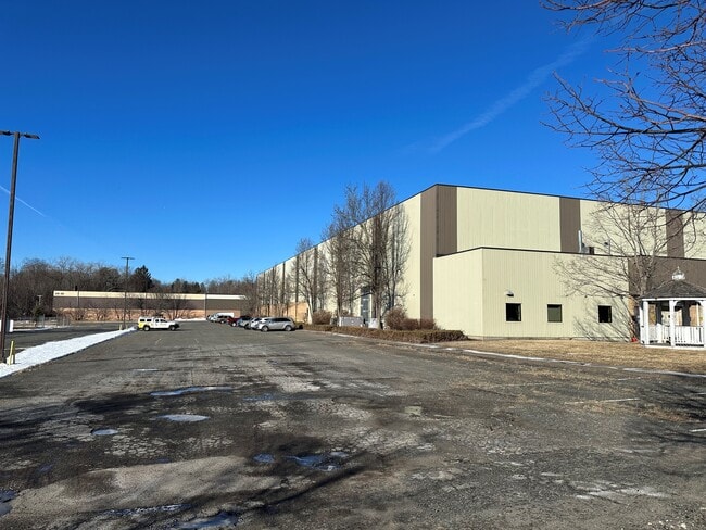
This Property Is For Sale
NEARBY LISTINGS FOR SALE OR LEASE
Property Detail
24 Gaylord St
Amherst Town-Northampton, MA
Hampshire
SHAD-000018-000071
Massachusetts
Industrialgeneral
13.29 AC
2025
Hampshire County
2025
Hartford
821000
DEMOGRAPHICS near 24 Gaylord St
1 Mile
3 Mile
5 Mile
2024 Total Population
7,526
65,543
110,740
2029 Population
6,266
61,801
103,622
Pop Growth 2024-2029
(16.74%)
(5.71%)
(6.43%)
Average Age
43
40
42
2024 Total Households
3,480
26,804
46,340
HH Growth 2024-2029
(17.27%)
(6.23%)
(6.85%)
Median Household Inc
$64,570
$54,004
$58,972
Avg Household Size
2.10
2.30
2.30
2024 Avg HH Vehicles
2.00
1.00
2.00
Median Home Value
$273,636
$257,387
$258,380
Median Year Built
1957
1954
1957
Nearby Places
Map Layers
Map Styles
 Street
 Aerial
- Restaurants
- Banks
- Shops
- Fitness
- Groceries
PUBLIC TRANSPORTATION
COMMUTER RAIL
DRIVE
WALK
Distance
5 min
1.6 mi
DRIVE
WALK
Distance
17 min
9.7 mi
AIRPORT
Bradley International
DRIVE
WALK
Distance
Bradley International
46 min
22.2 mi
Nearby Properties
Address
Land Use
TOTAL SIZE
Lot Size
Zoning
Address
Land Use
TOTAL SIZE
Lot Size
Zoning
22.15 AC
R-1A
Address
Land Use
TOTAL SIZE
Lot Size
Zoning
21.80 AC
106
Address
Land Use
TOTAL SIZE
Lot Size
Zoning
16.30 AC
RA2
Address
Land Use
TOTAL SIZE
Lot Size
Zoning
4.50 AC
RA2
Address
Land Use
TOTAL SIZE
Lot Size
Zoning
17.72 AC
R-2
Address
Land Use
TOTAL SIZE
Lot Size
Zoning
171,241 SF
18.94 AC
106
Address
Land Use
TOTAL SIZE
Lot Size
Zoning
26.68 AC
110
Address
Land Use
TOTAL SIZE
Lot Size
Zoning
9 AC
RA2
Address
Land Use
TOTAL SIZE
Lot Size
Zoning
2.41 AC
DR
Address
Land Use
TOTAL SIZE
Lot Size
Zoning
4.04 AC
107
Address
Land Use
TOTAL SIZE
Lot Size
Zoning
23,111 SF
1.43 AC
IA
Address
Land Use
TOTAL SIZE
Lot Size
Zoning
196,705 SF
21.45 AC
RM20
Address
Land Use
TOTAL SIZE
Lot Size
Zoning
201,410 SF
13.16 AC
RM20
Address
Land Use
TOTAL SIZE
Lot Size
Zoning
62,808 SF
7.60 AC
R-1
Address
Land Use
TOTAL SIZE
Lot Size
Zoning
26.35 AC
RA2
Address
Land Use
TOTAL SIZE
Lot Size
Zoning
194,875 SF
2.75 AC
IG
Address
Land Use
TOTAL SIZE
Lot Size
Zoning
64,638 SF
9.26 AC
RA2
Address
Land Use
TOTAL SIZE
Lot Size
Zoning
14.47 AC
110
Address
Land Use
TOTAL SIZE
Lot Size
Zoning
5.88 AC
IG
Address
Land Use
TOTAL SIZE
Lot Size
Zoning
161,190 SF
17.15 AC
RM20
Address
Land Use
TOTAL SIZE
Lot Size
Zoning
43,289 SF
2.63 AC
DR
Address
Land Use
TOTAL SIZE
Lot Size
Zoning
80,393 SF
1.71 AC
111
Address
Land Use
TOTAL SIZE
Lot Size
Zoning
10.62 AC
111A
Address
Land Use
TOTAL SIZE
Lot Size
Zoning
77,702 SF
16.39 AC
RM20
Address
Land Use
TOTAL SIZE
Lot Size
Zoning
812,675 SF
19.64 AC
BH
Address
Land Use
TOTAL SIZE
Lot Size
Zoning
3.30 AC
RA2
Address
Land Use
TOTAL SIZE
Lot Size
Zoning
152,380 SF
11.36 AC
110
Address
Land Use
TOTAL SIZE
Lot Size
Zoning
61,808 SF
8.53 AC
RA2
Address
Land Use
TOTAL SIZE
Lot Size
Zoning
291,714 SF
35.75 AC
110
Address
Land Use
TOTAL SIZE
Lot Size
Zoning
442 SF
0.85 AC
IG
The World's #1 Commercial Real Estate Marketplace
Connect with us
© 2026 CoStar Group
The information above has been obtained from sources believed reliable. While we do not doubt its accuracy we have not verified it and make no guarantee, warranty or representation about it. It is your responsibility to independently confirm its accuracy and completeness. Any projections, opinions, assumptions, or estimates used are for example only and do not represent the current or future performance of the property. The value of this transaction to you depends on tax and other factors which should be evaluated by your tax, financial, and legal advisors. You and your advisors should conduct a careful, independent investigation of the property to determine to your satisfaction the suitability of the property for your needs.