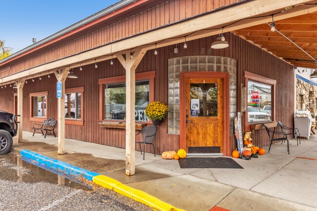
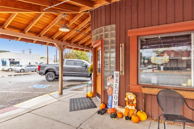
Property Record
20 S Main St, Three Forks, MT 59752

Property Detail
20 S Main St
06-1105-25-3-59-02-0000
THREE FORKS ORIG TWNSITE, S25, T02 N, R01 E, BLOCK 5, LOT 11, PLAT D-18
Bartavern
GALLATIN
6
Montana
C and X Area of minimal flood hazard, usually depicted on FIRMs as above the 500-year flood level.
11
2025
0.08 AC
2025
Bozeman/Yellowstone Country
000300
Other Market Areas
1,925 SF
Bozeman, MT
NEARBY LISTINGS FOR SALE OR LEASE
-
-
View all Three Forks listings for sale on LoopNet.com
DEMOGRAPHICS near 20 S Main St
1 mile
3 mile
5 mile
2025 Total Population
1,770
2,403
3,090
2030 Population
1,782
2,479
3,272
Pop Growth 2025-2030
+ 0.68%
+ 3.16%
+ 5.89%
Average Age
41
41
41
2025 Total Households
727
968
1,221
HH Growth 2025-2030
+ 0.96%
+ 3.10%
+ 5.57%
Median Household Inc
$88,337
$86,590
$84,645
Avg Household Size
2.40
2.50
2.50
2025 Avg HH Vehicles
3.00
3.00
3.00
Median Home Value
$429,130
$447,841
$462,576
Median Year Built
1982
1986
1990
Nearby Places
Map Layers
Map Styles
 Street
 Aerial
Layers
 Traffic
 Biking
Places
Listings with unknown addresses are not visible on the map
- Restaurants
- Banks
- Shops
- Fitness
- Groceries
PUBLIC TRANSPORTATION
AIRPORT
Bozeman Yellowstone International
Drive
Walk
Distance
Bozeman Yellowstone International
28 min
23.7 mi
Freight Ports
Port of Everett
Drive
Walk
Distance
Port of Everett
716 min
671.8 mi
SALE & LEASE HISTORY
LISTING DATE
SALE/LEASE

Oct 20, 2025
For Sale
Nearby Properties
Address
Land Use
TOTAL SIZE
Lot Size
Zoning
Address
Land Use
TOTAL SIZE
Lot Size
Zoning
7,240 SF
43.99 AC
1
Address
Land Use
TOTAL SIZE
Lot Size
Zoning
32,393 SF
21.60 AC
Address
Land Use
TOTAL SIZE
Lot Size
Zoning
52,995 SF
8 AC
Address
Land Use
TOTAL SIZE
Lot Size
Zoning
14,393 SF
4.91 AC
Address
Land Use
TOTAL SIZE
Lot Size
Zoning
17,862 SF
0.66 AC
6
Address
Land Use
TOTAL SIZE
Lot Size
Zoning
11,207 SF
2.60 AC
Address
Land Use
TOTAL SIZE
Lot Size
Zoning
10,429 SF
5.19 AC
Address
Land Use
TOTAL SIZE
Lot Size
Zoning
10,890 SF
2.43 AC
Address
Land Use
TOTAL SIZE
Lot Size
Zoning
1.53 AC
Address
Land Use
TOTAL SIZE
Lot Size
Zoning
6,996 SF
0.72 AC
1
Address
Land Use
TOTAL SIZE
Lot Size
Zoning
6,140 SF
1.14 AC
Address
Land Use
TOTAL SIZE
Lot Size
Zoning
2,855 SF
0.44 AC
6
Address
Land Use
TOTAL SIZE
Lot Size
Zoning
5,600 SF
0.96 AC
Address
Land Use
TOTAL SIZE
Lot Size
Zoning
7,064 SF
0.47 AC
6
Address
Land Use
TOTAL SIZE
Lot Size
Zoning
13,500 SF
8.73 AC
Address
Land Use
TOTAL SIZE
Lot Size
Zoning
6,110 SF
0.62 AC
6
Address
Land Use
TOTAL SIZE
Lot Size
Zoning
19,239 SF
29.15 AC
6
Address
Land Use
TOTAL SIZE
Lot Size
Zoning
3,600 SF
3.05 AC
Address
Land Use
TOTAL SIZE
Lot Size
Zoning
8,296 SF
1.01 AC
Address
Land Use
TOTAL SIZE
Lot Size
Zoning
7,362 SF
7.42 AC
Address
Land Use
TOTAL SIZE
Lot Size
Zoning
9,800 SF
0.16 AC
6
Address
Land Use
TOTAL SIZE
Lot Size
Zoning
4,444 SF
0.32 AC
9
Address
Land Use
TOTAL SIZE
Lot Size
Zoning
5,938 SF
0.48 AC
1
Address
Land Use
TOTAL SIZE
Lot Size
Zoning
5,292 SF
0.48 AC
1
Address
Land Use
TOTAL SIZE
Lot Size
Zoning
8,800 SF
0.48 AC
6
Address
Land Use
TOTAL SIZE
Lot Size
Zoning
8,592 SF
0.16 AC
6
Address
Land Use
TOTAL SIZE
Lot Size
Zoning
3,486 SF
0.33 AC
Address
Land Use
TOTAL SIZE
Lot Size
Zoning
4,350 SF
0.16 AC
6
Address
Land Use
TOTAL SIZE
Lot Size
Zoning
2,824 SF
10 AC
Address
Land Use
TOTAL SIZE
Lot Size
Zoning
12,566 SF
7.80 AC
1
The World's #1 Commercial Real Estate Marketplace
Connect with us
© 2026 CoStar Group
The information above has been obtained from sources believed reliable. While we do not doubt its accuracy we have not verified it and make no guarantee, warranty or representation about it. It is your responsibility to independently confirm its accuracy and completeness. Any projections, opinions, assumptions, or estimates used are for example only and do not represent the current or future performance of the property. The value of this transaction to you depends on tax and other factors which should be evaluated by your tax, financial, and legal advisors. You and your advisors should conduct a careful, independent investigation of the property to determine to your satisfaction the suitability of the property for your needs.