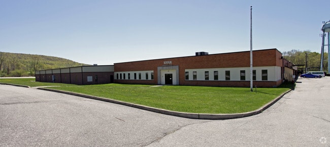
Property Record
24 Munsonhurst Rd, Franklin, NJ 07416


Save to a Folder
{{folder.Name}}
{{folder.ListingIds.length}} Properties
{{folder.ListingIds.length}} Property
Create a New Folder
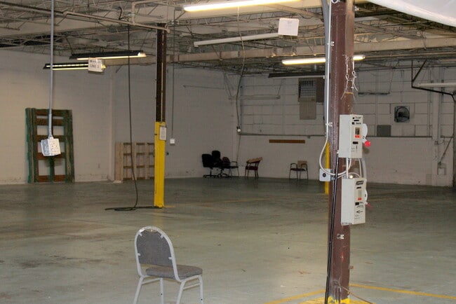
Property Detail
24 Munsonhurst Rd
06-02401-0000-00021
Sussex
Industrialgeneral
New Jersey
I
21
B and X Area of moderate flood hazard, usually the area between the limits of the 100-year and 500-year floods.
10.37 AC
2025
Sussex County
2026
Northern New Jersey
372800
Newark, NJ
NEARBY LISTINGS FOR SALE OR LEASE
-
-
View all Franklin listings for lease on LoopNet.com
DEMOGRAPHICS near 24 Munsonhurst Rd
1 mile
3 mile
5 mile
2025 Total Population
1,315
12,660
27,961
2030 Population
1,340
12,964
28,720
Pop Growth 2025-2030
+ 1.90%
+ 2.40%
+ 2.71%
Average Age
44
43
43
2025 Total Households
536
5,081
11,009
HH Growth 2025-2030
+ 1.87%
+ 2.38%
+ 2.73%
Median Household Inc
$87,142
$95,595
$112,463
Avg Household Size
2.40
2.50
2.50
2025 Avg HH Vehicles
2.00
2.00
2.00
Median Home Value
$273,928
$335,533
$372,964
Median Year Built
1959
1965
1978
Nearby Places
Map Layers
Map Styles
 Street
 Aerial
Layers
 Traffic
 Biking
Places
Listings with unknown addresses are not visible on the map
- Restaurants
- Banks
- Shops
- Fitness
- Groceries
SALE & LEASE HISTORY
LISTING DATE
SALE/LEASE

Sep 25, 2016
For Lease
Sep 23, 2016
For Sale
May 28, 2019
For Lease
Feb 12, 2021
For Lease
Nearby Properties
Address
Land Use
TOTAL SIZE
Lot Size
Zoning
Address
Land Use
TOTAL SIZE
Lot Size
Zoning
66.06 AC
GC
Address
Land Use
TOTAL SIZE
Lot Size
Zoning
10.83 AC
OSGU
Address
Land Use
TOTAL SIZE
Lot Size
Zoning
Address
Land Use
TOTAL SIZE
Lot Size
Zoning
52,776 SF
7.53 AC
R40
Address
Land Use
TOTAL SIZE
Lot Size
Zoning
1,150.36 AC
MD10
Address
Land Use
TOTAL SIZE
Lot Size
Zoning
10.02 AC
HC-1
Address
Land Use
TOTAL SIZE
Lot Size
Zoning
16.88 AC
HC-1
Address
Land Use
TOTAL SIZE
Lot Size
Zoning
21.48 AC
R-1
Address
Land Use
TOTAL SIZE
Lot Size
Zoning
1,001.49 AC
B-1
Address
Land Use
TOTAL SIZE
Lot Size
Zoning
0.90 AC
Address
Land Use
TOTAL SIZE
Lot Size
Zoning
38.17 AC
HC-1
Address
Land Use
TOTAL SIZE
Lot Size
Zoning
3,048 SF
51 AC
I-2
Address
Land Use
TOTAL SIZE
Lot Size
Zoning
836 SF
10 AC
I-1
Address
Land Use
TOTAL SIZE
Lot Size
Zoning
5.62 AC
HC-1
Address
Land Use
TOTAL SIZE
Lot Size
Zoning
Address
Land Use
TOTAL SIZE
Lot Size
Zoning
2.20 AC
BAR
Address
Land Use
TOTAL SIZE
Lot Size
Zoning
Address
Land Use
TOTAL SIZE
Lot Size
Zoning
10.29 AC
MID3
Address
Land Use
TOTAL SIZE
Lot Size
Zoning
960 SF
3.38 AC
B-1
Address
Land Use
TOTAL SIZE
Lot Size
Zoning
9.02 AC
B-1
Address
Land Use
TOTAL SIZE
Lot Size
Zoning
6 AC
GC
Address
Land Use
TOTAL SIZE
Lot Size
Zoning
1,920 SF
1.59 AC
HC-1
Address
Land Use
TOTAL SIZE
Lot Size
Zoning
Address
Land Use
TOTAL SIZE
Lot Size
Zoning
958 SF
196 AC
MID1
Address
Land Use
TOTAL SIZE
Lot Size
Zoning
3.95 AC
I-2
Address
Land Use
TOTAL SIZE
Lot Size
Zoning
5.19 AC
I-2
Address
Land Use
TOTAL SIZE
Lot Size
Zoning
5.58 AC
B-I
Address
Land Use
TOTAL SIZE
Lot Size
Zoning
82,728 SF
4.58 AC
R20
Address
Land Use
TOTAL SIZE
Lot Size
Zoning
676.50 AC
OSGU
The World's #1 Commercial Real Estate Marketplace
Connect with us
© 2026 CoStar Group
The information above has been obtained from sources believed reliable. While we do not doubt its accuracy we have not verified it and make no guarantee, warranty or representation about it. It is your responsibility to independently confirm its accuracy and completeness. Any projections, opinions, assumptions, or estimates used are for example only and do not represent the current or future performance of the property. The value of this transaction to you depends on tax and other factors which should be evaluated by your tax, financial, and legal advisors. You and your advisors should conduct a careful, independent investigation of the property to determine to your satisfaction the suitability of the property for your needs.