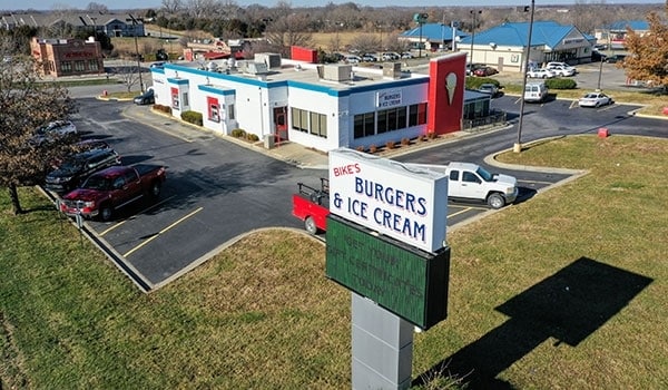
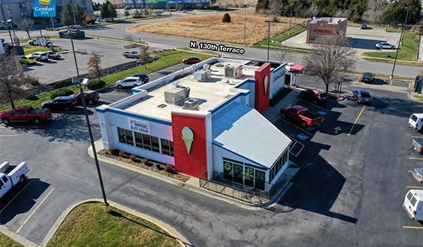
Property Record
24 N 130Th St, Bonner Springs, KS 66012

Current Lease Availabilities
NEARBY LISTINGS FOR SALE OR LEASE
Property Detail
24 N 130Th St
Kansas City, MO-KS
Canaan Center
253202
CANAAN CENTER, S17, T11, R23, ACRES 1.03, L3
Restaurantdrivein
Wyandotte
X
Kansas
20209C0110E
3
2025
1.03 AC
2025
Kansas City KS
044807
Kansas City
4,108 SF
DEMOGRAPHICS near 24 N 130Th St
1 Mile
3 Mile
5 Mile
2024 Total Population
1,055
10,584
40,666
2029 Population
1,007
10,282
40,477
Pop Growth 2024-2029
(4.55%)
(2.85%)
(0.46%)
Average Age
40
39
39
2024 Total Households
406
4,255
14,848
HH Growth 2024-2029
(4.68%)
(2.98%)
(0.66%)
Median Household Inc
$106,720
$87,964
$100,060
Avg Household Size
2.60
2.50
2.70
2024 Avg HH Vehicles
2.00
2.00
2.00
Median Home Value
$258,024
$237,727
$282,679
Median Year Built
1987
1991
1995
Nearby Places
Map Layers
Map Styles
 Street
 Aerial
- Restaurants
- Banks
- Shops
- Fitness
- Groceries
PUBLIC TRANSPORTATION
AIRPORT
Kansas City International
DRIVE
WALK
Distance
Kansas City International
36 min
28.8 mi
Nearby Properties
Address
Land Use
TOTAL SIZE
Lot Size
Zoning
Address
Land Use
TOTAL SIZE
Lot Size
Zoning
920,306 SF
90.21 AC
Address
Land Use
TOTAL SIZE
Lot Size
Zoning
103,299 SF
13.41 AC
Address
Land Use
TOTAL SIZE
Lot Size
Zoning
87,287 SF
10.30 AC
Address
Land Use
TOTAL SIZE
Lot Size
Zoning
16,603 SF
133.44 AC
Address
Land Use
TOTAL SIZE
Lot Size
Zoning
297,198 SF
60.55 AC
Address
Land Use
TOTAL SIZE
Lot Size
Zoning
58,897 SF
141.52 AC
BA1
Address
Land Use
TOTAL SIZE
Lot Size
Zoning
86,176 SF
49.23 AC
KAG
Address
Land Use
TOTAL SIZE
Lot Size
Zoning
141,032 SF
68.59 AC
A1
Address
Land Use
TOTAL SIZE
Lot Size
Zoning
28,210 SF
317.17 AC
Address
Land Use
TOTAL SIZE
Lot Size
Zoning
390,400 SF
59.71 AC
Address
Land Use
TOTAL SIZE
Lot Size
Zoning
69,406 SF
29.75 AC
Address
Land Use
TOTAL SIZE
Lot Size
Zoning
26,738 SF
82.01 AC
Address
Land Use
TOTAL SIZE
Lot Size
Zoning
24,933 SF
17.16 AC
KAG
Address
Land Use
TOTAL SIZE
Lot Size
Zoning
27,784 SF
2.53 AC
BC1
Address
Land Use
TOTAL SIZE
Lot Size
Zoning
6,380 SF
296.16 AC
BA1
Address
Land Use
TOTAL SIZE
Lot Size
Zoning
13,024 SF
140.65 AC
Address
Land Use
TOTAL SIZE
Lot Size
Zoning
57,743 SF
6.18 AC
BR2
Address
Land Use
TOTAL SIZE
Lot Size
Zoning
19,113 SF
2.06 AC
BA2
Address
Land Use
TOTAL SIZE
Lot Size
Zoning
29,323 SF
250.53 AC
BA1
Address
Land Use
TOTAL SIZE
Lot Size
Zoning
243,984 SF
13.54 AC
BR
Address
Land Use
TOTAL SIZE
Lot Size
Zoning
7,167 SF
1.01 AC
BR2
Address
Land Use
TOTAL SIZE
Lot Size
Zoning
3,340 SF
119.11 AC
BR
Address
Land Use
TOTAL SIZE
Lot Size
Zoning
167,873 SF
18.68 AC
BR2
Address
Land Use
TOTAL SIZE
Lot Size
Zoning
26,798 SF
9.65 AC
Address
Land Use
TOTAL SIZE
Lot Size
Zoning
15,657 SF
1.46 AC
Address
Land Use
TOTAL SIZE
Lot Size
Zoning
154.64 AC
WC
Address
Land Use
TOTAL SIZE
Lot Size
Zoning
29,615 SF
1.98 AC
BR2
Address
Land Use
TOTAL SIZE
Lot Size
Zoning
20,354 SF
12.54 AC
BI1
Address
Land Use
TOTAL SIZE
Lot Size
Zoning
10,320 SF
38.08 AC
Address
Land Use
TOTAL SIZE
Lot Size
Zoning
20,025 SF
5.32 AC
BA2
The World's #1 Commercial Real Estate Marketplace
Connect with us
© 2025 CoStar Group
The information above has been obtained from sources believed reliable. While we do not doubt its accuracy we have not verified it and make no guarantee, warranty or representation about it. It is your responsibility to independently confirm its accuracy and completeness. Any projections, opinions, assumptions, or estimates used are for example only and do not represent the current or future performance of the property. The value of this transaction to you depends on tax and other factors which should be evaluated by your tax, financial, and legal advisors. You and your advisors should conduct a careful, independent investigation of the property to determine to your satisfaction the suitability of the property for your needs.