Property Record
24 N Main St, Pennington, NJ 08534
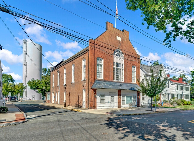

This Property Is For Sale
Current Lease Availabilities
Property Detail
24 N Main St
08-00205-0000-00019
Mercer
Commercialnec
New Jersey
O-R
19
B and X Area of moderate flood hazard, usually the area between the limits of the 100-year and 500-year floods.
0.13 AC
2024
Trenton
2025
Northern New Jersey
003903
Trenton-Princeton, NJ
6,333 SF
NEARBY LISTINGS FOR SALE OR LEASE
DEMOGRAPHICS near 24 N Main St
1 mile
3 mile
5 mile
2025 Total Population
4,147
15,489
57,648
2030 Population
4,286
15,962
59,672
Pop Growth 2025-2030
+ 3.35%
+ 3.05%
+ 3.51%
Average Age
43
43
43
2025 Total Households
1,522
5,836
21,908
HH Growth 2025-2030
+ 3.81%
+ 3.26%
+ 4.20%
Median Household Inc
$165,131
$169,192
$125,814
Avg Household Size
2.60
2.60
2.40
2025 Avg HH Vehicles
2.00
2.00
2.00
Median Home Value
$628,172
$614,688
$469,295
Median Year Built
1962
1984
1976
Nearby Places
Map Layers
Map Styles
 Street
 Aerial
Layers
 Traffic
 Biking
Places
Listings with unknown addresses are not visible on the map
- Restaurants
- Banks
- Shops
- Fitness
- Groceries
PUBLIC TRANSPORTATION
COMMUTER RAIL
West Trenton (R3 - Southeastern Pennsylvania Transportation Authority Regional Rail (SEPTA Regional Rail))
Drive
Walk
Distance
West Trenton (R3 - Southeastern Pennsylvania Transportation Authority Regional Rail (SEPTA Regional Rail))
14 min
7.3 mi
Princeton (Princeton Branch - NJ Transit Commuter Rail (NJ Transit))
Drive
Walk
Distance
Princeton (Princeton Branch - NJ Transit Commuter Rail (NJ Transit))
18 min
8.5 mi
AIRPORT
Trenton Mercer
Drive
Walk
Distance
Trenton Mercer
13 min
5.5 mi
Philadelphia International
Drive
Walk
Distance
Philadelphia International
70 min
48.0 mi
Freight Ports
Port of Philadelphia
Drive
Walk
Distance
Port of Philadelphia
50 min
34.4 mi
Nearby Properties
Address
Land Use
TOTAL SIZE
Lot Size
Zoning
Address
Land Use
TOTAL SIZE
Lot Size
Zoning
42 AC
R03
Address
Land Use
TOTAL SIZE
Lot Size
Zoning
13.86 AC
OP
Address
Land Use
TOTAL SIZE
Lot Size
Zoning
156.92 AC
R03
Address
Land Use
TOTAL SIZE
Lot Size
Zoning
42 AC
R03
Address
Land Use
TOTAL SIZE
Lot Size
Zoning
13.36 AC
OP
Address
Land Use
TOTAL SIZE
Lot Size
Zoning
0.35 AC
OP
Address
Land Use
TOTAL SIZE
Lot Size
Zoning
7.85 AC
OP
Address
Land Use
TOTAL SIZE
Lot Size
Zoning
6.09 AC
OP
Address
Land Use
TOTAL SIZE
Lot Size
Zoning
8.73 AC
OP
Address
Land Use
TOTAL SIZE
Lot Size
Zoning
Address
Land Use
TOTAL SIZE
Lot Size
Zoning
Address
Land Use
TOTAL SIZE
Lot Size
Zoning
38.82 AC
R100
Address
Land Use
TOTAL SIZE
Lot Size
Zoning
0.32 AC
OP
Address
Land Use
TOTAL SIZE
Lot Size
Zoning
6.37 AC
OP
Address
Land Use
TOTAL SIZE
Lot Size
Zoning
8.35 AC
OP
Address
Land Use
TOTAL SIZE
Lot Size
Zoning
6.01 AC
OP
Address
Land Use
TOTAL SIZE
Lot Size
Zoning
20.93 AC
HBO
Address
Land Use
TOTAL SIZE
Lot Size
Zoning
58,800 SF
20.55 AC
IP1
Address
Land Use
TOTAL SIZE
Lot Size
Zoning
0.27 AC
OP
Address
Land Use
TOTAL SIZE
Lot Size
Zoning
9.87 AC
R-5
Address
Land Use
TOTAL SIZE
Lot Size
Zoning
221.99 AC
2ZON
Address
Land Use
TOTAL SIZE
Lot Size
Zoning
107,927 SF
32.87 AC
R-80
Address
Land Use
TOTAL SIZE
Lot Size
Zoning
Address
Land Use
TOTAL SIZE
Lot Size
Zoning
16.34 AC
SC
Address
Land Use
TOTAL SIZE
Lot Size
Zoning
22.61 AC
IP-1
Address
Land Use
TOTAL SIZE
Lot Size
Zoning
0.34 AC
OP
Address
Land Use
TOTAL SIZE
Lot Size
Zoning
Address
Land Use
TOTAL SIZE
Lot Size
Zoning
22.37 AC
2ZON
Address
Land Use
TOTAL SIZE
Lot Size
Zoning
0.25 AC
OP
Address
Land Use
TOTAL SIZE
Lot Size
Zoning
The World's #1 Commercial Real Estate Marketplace
Connect with us
© 2026 CoStar Group
The information above has been obtained from sources believed reliable. While we do not doubt its accuracy we have not verified it and make no guarantee, warranty or representation about it. It is your responsibility to independently confirm its accuracy and completeness. Any projections, opinions, assumptions, or estimates used are for example only and do not represent the current or future performance of the property. The value of this transaction to you depends on tax and other factors which should be evaluated by your tax, financial, and legal advisors. You and your advisors should conduct a careful, independent investigation of the property to determine to your satisfaction the suitability of the property for your needs.