Property Record
24 Pyne Rd, Lagrange, GA 30240
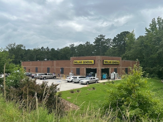

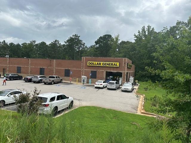
This Property Is For Sale
Property Detail
24 Pyne Rd
080-2-000-004
24 PYNE RD/ PDB 284/503
Wholesaleoutletdiscountstore
Troup
01-LC
Georgia
B and X Area of moderate flood hazard, usually the area between the limits of the 100-year and 500-year floods.
2.27 AC
2025
Troup County
2025
Columbus GA
960903
LaGrange, GA-AL
10,729 SF
NEARBY LISTINGS FOR SALE OR LEASE
-
-
View all Lagrange listings for sale on LoopNet.com
DEMOGRAPHICS near 24 Pyne Rd
1 mile
3 mile
5 mile
2024 Total Population
613
5,891
11,078
2029 Population
612
5,907
11,118
Pop Growth 2024-2029
(0.16%)
+ 0.27%
+ 0.36%
Average Age
43
41
42
2024 Total Households
234
2,234
4,260
HH Growth 2024-2029
0.00%
+ 0.27%
+ 0.40%
Median Household Inc
$68,124
$72,726
$63,027
Avg Household Size
2.60
2.60
2.50
2024 Avg HH Vehicles
2.00
2.00
2.00
Median Home Value
$204,878
$200,107
$211,831
Median Year Built
1984
1988
1989
Nearby Places
Map Layers
Map Styles
 Street
 Aerial
Transit
 Traffic
 Biking
Places
Listings with unknown addresses are not visible on the map
- Restaurants
- Banks
- Shops
- Fitness
- Groceries
Nearby Properties
Address
Land Use
TOTAL SIZE
Lot Size
Zoning
Address
Land Use
TOTAL SIZE
Lot Size
Zoning
20,129 SF
357.53 AC
01-LR
Address
Land Use
TOTAL SIZE
Lot Size
Zoning
206.26 AC
01-AG
Address
Land Use
TOTAL SIZE
Lot Size
Zoning
16,570 SF
11.94 AC
01-SU-R
Address
Land Use
TOTAL SIZE
Lot Size
Zoning
4,060 SF
0.51 AC
01-LC
Address
Land Use
TOTAL SIZE
Lot Size
Zoning
14,216 SF
4.93 AC
01-SU-R
Address
Land Use
TOTAL SIZE
Lot Size
Zoning
9,580 SF
6.50 AC
01-SU-R
Address
Land Use
TOTAL SIZE
Lot Size
Zoning
8,662 SF
8.19 AC
01-SU-R
Address
Land Use
TOTAL SIZE
Lot Size
Zoning
9,344 SF
1.42 AC
01-LC
Address
Land Use
TOTAL SIZE
Lot Size
Zoning
12,886 SF
1.46 AC
01-SU-R
Address
Land Use
TOTAL SIZE
Lot Size
Zoning
251.65 AC
01-SU-R
Address
Land Use
TOTAL SIZE
Lot Size
Zoning
20,000 SF
2.94 AC
01-LC
Address
Land Use
TOTAL SIZE
Lot Size
Zoning
1,938 SF
6.20 AC
01-SD-MH
Address
Land Use
TOTAL SIZE
Lot Size
Zoning
3,848 SF
3.28 AC
01-SU-R
Address
Land Use
TOTAL SIZE
Lot Size
Zoning
124.40 AC
01-SU-R
Address
Land Use
TOTAL SIZE
Lot Size
Zoning
4,800 SF
0.70 AC
01-LC
Address
Land Use
TOTAL SIZE
Lot Size
Zoning
10,560 SF
1.43 AC
01-LC
Address
Land Use
TOTAL SIZE
Lot Size
Zoning
6,595 SF
1.69 AC
01-LC
Address
Land Use
TOTAL SIZE
Lot Size
Zoning
3,285 SF
0.50 AC
01-LC
Address
Land Use
TOTAL SIZE
Lot Size
Zoning
3,435 SF
0.37 AC
01-LC
Address
Land Use
TOTAL SIZE
Lot Size
Zoning
898 SF
15 AC
01-AG
Address
Land Use
TOTAL SIZE
Lot Size
Zoning
768 SF
0.24 AC
01-LR
Address
Land Use
TOTAL SIZE
Lot Size
Zoning
50.36 AC
01-LR
Address
Land Use
TOTAL SIZE
Lot Size
Zoning
2,700 SF
2.23 AC
01-LC
Address
Land Use
TOTAL SIZE
Lot Size
Zoning
74.90 AC
01-LR
Address
Land Use
TOTAL SIZE
Lot Size
Zoning
112.25 AC
01-SU-R
Address
Land Use
TOTAL SIZE
Lot Size
Zoning
4,404 SF
8 AC
01-SU-R
Address
Land Use
TOTAL SIZE
Lot Size
Zoning
22.79 AC
01-SU-R
Address
Land Use
TOTAL SIZE
Lot Size
Zoning
6,948 SF
2.70 AC
01-LC
Address
Land Use
TOTAL SIZE
Lot Size
Zoning
84.60 AC
01-SU-R
The World's #1 Commercial Real Estate Marketplace
Connect with us
© 2026 CoStar Group
The information above has been obtained from sources believed reliable. While we do not doubt its accuracy we have not verified it and make no guarantee, warranty or representation about it. It is your responsibility to independently confirm its accuracy and completeness. Any projections, opinions, assumptions, or estimates used are for example only and do not represent the current or future performance of the property. The value of this transaction to you depends on tax and other factors which should be evaluated by your tax, financial, and legal advisors. You and your advisors should conduct a careful, independent investigation of the property to determine to your satisfaction the suitability of the property for your needs.