Property Record
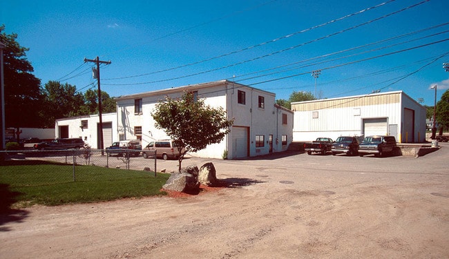
24 Ryder St, Arlington, MA 02476


NEARBY LISTINGS FOR SALE OR LEASE
-
-
View all Arlington listings for sale on LoopNet.com
Property Detail
24 Ryder St
ARLI-000057-000001-000007A
Middlesex
Warehouse
Massachusetts
X
7.a
25017C0416F
0.17 AC
2025
Lexington/Arlington
2025
Boston
356601
Boston-Cambridge-Newton, MA-NH
5,526 SF
DEMOGRAPHICS near 24 Ryder St
1 Mile
3 Mile
5 Mile
2024 Total Population
24,126
144,395
444,600
2029 Population
23,807
142,642
437,522
Pop Growth 2024-2029
(1.32%)
(1.21%)
(1.59%)
Average Age
42
41
40
2024 Total Households
9,700
56,021
179,149
HH Growth 2024-2029
(1.40%)
(1.37%)
(1.72%)
Median Household Inc
$140,514
$141,075
$120,766
Avg Household Size
2.40
2.40
2.30
2024 Avg HH Vehicles
2.00
2.00
1.00
Median Home Value
$784,658
$875,790
$814,827
Median Year Built
1951
1952
1950
Nearby Places
Map Layers
Map Styles
 Street
 Aerial
- Restaurants
- Banks
- Shops
- Fitness
- Groceries
PUBLIC TRANSPORTATION
COMMUTER RAIL
Belmont Center (Fitchburg/South Acton Line - Massachusetts Bay Transportation Authority Commuter Rail (Purple Line))
DRIVE
WALK
Distance
Belmont Center (Fitchburg/South Acton Line - Massachusetts Bay Transportation Authority Commuter Rail (Purple Line))
6 min
2.7 mi
West Medford (Lowell Line - Massachusetts Bay Transportation Authority Commuter Rail (Purple Line))
DRIVE
WALK
Distance
West Medford (Lowell Line - Massachusetts Bay Transportation Authority Commuter Rail (Purple Line))
7 min
2.9 mi
AIRPORT
General Edward Lawrence Logan International
DRIVE
WALK
Distance
General Edward Lawrence Logan International
22 min
11.7 mi
Freight Ports
Port of Boston
DRIVE
WALK
Distance
Port of Boston
23 min
11.4 mi
Nearby Properties
Address
Land Use
TOTAL SIZE
Lot Size
Zoning
Address
Land Use
TOTAL SIZE
Lot Size
Zoning
283,554 SF
2.76 AC
O-2A
Address
Land Use
TOTAL SIZE
Lot Size
Zoning
54,500 SF
4.01 AC
O-2A
Address
Land Use
TOTAL SIZE
Lot Size
Zoning
2.87 AC
O-2A
Address
Land Use
TOTAL SIZE
Lot Size
Zoning
213,834 SF
1.48 AC
SD-4
Address
Land Use
TOTAL SIZE
Lot Size
Zoning
224,115 SF
2.35 AC
O-2A
Address
Land Use
TOTAL SIZE
Lot Size
Zoning
472,329 SF
22.11 AC
CD
Address
Land Use
TOTAL SIZE
Lot Size
Zoning
244,008 SF
4 AC
SD-4A
Address
Land Use
TOTAL SIZE
Lot Size
Zoning
530,113 SF
29.43 AC
Address
Land Use
TOTAL SIZE
Lot Size
Zoning
117,783 SF
0.63 AC
Address
Land Use
TOTAL SIZE
Lot Size
Zoning
169 AC
OS
Address
Land Use
TOTAL SIZE
Lot Size
Zoning
12.90 AC
R
Address
Land Use
TOTAL SIZE
Lot Size
Zoning
16.79 AC
BA
Address
Land Use
TOTAL SIZE
Lot Size
Zoning
155,866 SF
2.60 AC
O-1
Address
Land Use
TOTAL SIZE
Lot Size
Zoning
145,839 SF
1.81 AC
O-2A
Address
Land Use
TOTAL SIZE
Lot Size
Zoning
25,000 SF
25.73 AC
RD
Address
Land Use
TOTAL SIZE
Lot Size
Zoning
79.60 AC
SD
Address
Land Use
TOTAL SIZE
Lot Size
Zoning
73.10 AC
SA
Address
Land Use
TOTAL SIZE
Lot Size
Zoning
153,732 SF
12.50 AC
SCI
Address
Land Use
TOTAL SIZE
Lot Size
Zoning
218,825 SF
2.93 AC
O-2A
Address
Land Use
TOTAL SIZE
Lot Size
Zoning
139,520 SF
1.21 AC
SD-4
Address
Land Use
TOTAL SIZE
Lot Size
Zoning
44.94 AC
R2
Address
Land Use
TOTAL SIZE
Lot Size
Zoning
208,852 SF
16.17 AC
MU
Address
Land Use
TOTAL SIZE
Lot Size
Zoning
38.10 AC
B
Address
Land Use
TOTAL SIZE
Lot Size
Zoning
69,045 SF
6.76 AC
Address
Land Use
TOTAL SIZE
Lot Size
Zoning
4,260 SF
76.95 AC
OS
Address
Land Use
TOTAL SIZE
Lot Size
Zoning
75.78 AC
SD
Address
Land Use
TOTAL SIZE
Lot Size
Zoning
76,359 SF
1.50 AC
O-1
Address
Land Use
TOTAL SIZE
Lot Size
Zoning
157,317 SF
3.87 AC
B2A
Address
Land Use
TOTAL SIZE
Lot Size
Zoning
2.53 AC
O-1
Address
Land Use
TOTAL SIZE
Lot Size
Zoning
147,090 SF
5.07 AC
The World's #1 Commercial Real Estate Marketplace
Connect with us
© 2026 CoStar Group
The information above has been obtained from sources believed reliable. While we do not doubt its accuracy we have not verified it and make no guarantee, warranty or representation about it. It is your responsibility to independently confirm its accuracy and completeness. Any projections, opinions, assumptions, or estimates used are for example only and do not represent the current or future performance of the property. The value of this transaction to you depends on tax and other factors which should be evaluated by your tax, financial, and legal advisors. You and your advisors should conduct a careful, independent investigation of the property to determine to your satisfaction the suitability of the property for your needs.