Property Record
24 Santos Rd, West Warren, MA 01092
NEARBY LISTINGS FOR SALE OR LEASE
-
-
View all West Warren listings for sale on LoopNet.com
Property Detail
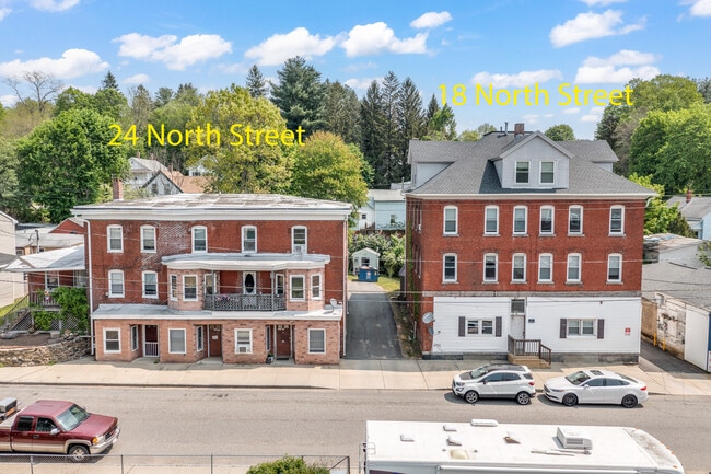
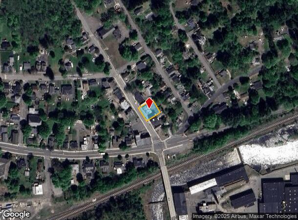
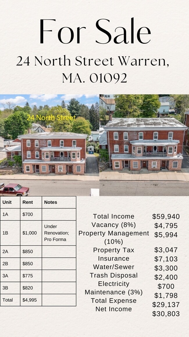
24 Santos Rd
WARR-000021-000000-000009
Worcester
Apartment
Massachusetts
ARE
9
25013C0278E
0.20 AC
2025
Outlying Worcester County
2025
Boston
761100
Worcester, MA-CT
5,359 SF
DEMOGRAPHICS near 24 Santos Rd
1 Mile
3 Mile
5 Mile
2024 Total Population
963
6,071
18,250
2029 Population
939
5,759
16,494
Pop Growth 2024-2029
(2.49%)
(5.14%)
(9.62%)
Average Age
41
42
43
2024 Total Households
389
2,550
7,646
HH Growth 2024-2029
(2.57%)
(5.53%)
(10.15%)
Median Household Inc
$61,607
$60,550
$64,623
Avg Household Size
2.50
2.40
2.40
2024 Avg HH Vehicles
2.00
2.00
2.00
Median Home Value
$291,817
$288,878
$273,556
Median Year Built
1947
1974
1972
Nearby Places
- Restaurants
- Banks
- Shops
- Fitness
- Groceries
PUBLIC TRANSPORTATION
AIRPORT
Worcester Regional
DRIVE
WALK
Distance
Worcester Regional
46 min
25.1 mi
Bradley International
DRIVE
WALK
Distance
Bradley International
67 min
37.9 mi
Freight Ports
Port of Davisville, RI
DRIVE
WALK
Distance
Port of Davisville, RI
115 min
85.3 mi
SALE & LEASE HISTORY
LISTING DATE
SALE/LEASE

Jun 01, 2023
For Sale
Apr 01, 2022
For Sale
Nearby Properties
Address
Land Use
TOTAL SIZE
Lot Size
Zoning
Address
Land Use
TOTAL SIZE
Lot Size
Zoning
110,982 SF
6.08 AC
SR
Address
Land Use
TOTAL SIZE
Lot Size
Zoning
162,818 SF
21.37 AC
CI
Address
Land Use
TOTAL SIZE
Lot Size
Zoning
131,737 SF
20.78 AC
CI
Address
Land Use
TOTAL SIZE
Lot Size
Zoning
97,336 SF
25.28 AC
RUR
Address
Land Use
TOTAL SIZE
Lot Size
Zoning
277,467 SF
9.87 AC
I
Address
Land Use
TOTAL SIZE
Lot Size
Zoning
96,983 SF
60 AC
VIL
Address
Land Use
TOTAL SIZE
Lot Size
Zoning
25,042 SF
3.70 AC
CI
Address
Land Use
TOTAL SIZE
Lot Size
Zoning
55,633 SF
8.59 AC
HC
Address
Land Use
TOTAL SIZE
Lot Size
Zoning
18,075 SF
4.38 AC
HC
Address
Land Use
TOTAL SIZE
Lot Size
Zoning
236,071 SF
35.57 AC
VIL
Address
Land Use
TOTAL SIZE
Lot Size
Zoning
10,874 SF
8 AC
I
Address
Land Use
TOTAL SIZE
Lot Size
Zoning
10.90 AC
VIL
Address
Land Use
TOTAL SIZE
Lot Size
Zoning
20,280 SF
5.83 AC
RUR
Address
Land Use
TOTAL SIZE
Lot Size
Zoning
133,226 SF
21.37 AC
SR
Address
Land Use
TOTAL SIZE
Lot Size
Zoning
374.61 AC
RR
Address
Land Use
TOTAL SIZE
Lot Size
Zoning
4,513 SF
0.64 AC
RB
Address
Land Use
TOTAL SIZE
Lot Size
Zoning
330.12 AC
RR
Address
Land Use
TOTAL SIZE
Lot Size
Zoning
12,308 SF
3.50 AC
RB
Address
Land Use
TOTAL SIZE
Lot Size
Zoning
14,500 SF
0.34 AC
VIL
Address
Land Use
TOTAL SIZE
Lot Size
Zoning
424,963 SF
65.60 AC
COM
Address
Land Use
TOTAL SIZE
Lot Size
Zoning
3.77 AC
VIL
Address
Land Use
TOTAL SIZE
Lot Size
Zoning
0.62 AC
VIL
Address
Land Use
TOTAL SIZE
Lot Size
Zoning
9,400 SF
1.40 AC
VIL
Address
Land Use
TOTAL SIZE
Lot Size
Zoning
10,080 SF
0.47 AC
VIL
Address
Land Use
TOTAL SIZE
Lot Size
Zoning
8,908 SF
1.31 AC
HC
Address
Land Use
TOTAL SIZE
Lot Size
Zoning
9,300 SF
29.57 AC
RB
Address
Land Use
TOTAL SIZE
Lot Size
Zoning
18.95 AC
CI
Address
Land Use
TOTAL SIZE
Lot Size
Zoning
31,128 SF
7.50 AC
RB
Address
Land Use
TOTAL SIZE
Lot Size
Zoning
150 AC
AR
Address
Land Use
TOTAL SIZE
Lot Size
Zoning
6.60 AC
VIL
The World's #1 Commercial Real Estate Marketplace
Connect with us
© 2025 CoStar Group
The information above has been obtained from sources believed reliable. While we do not doubt its accuracy we have not verified it and make no guarantee, warranty or representation about it. It is your responsibility to independently confirm its accuracy and completeness. Any projections, opinions, assumptions, or estimates used are for example only and do not represent the current or future performance of the property. The value of this transaction to you depends on tax and other factors which should be evaluated by your tax, financial, and legal advisors. You and your advisors should conduct a careful, independent investigation of the property to determine to your satisfaction the suitability of the property for your needs.