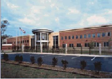
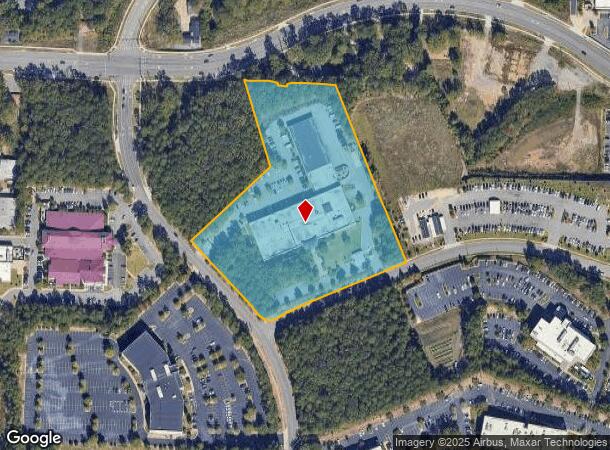
Property Record
24 Shackleford West Blvd, Little Rock, AR 72211
NEARBY LISTINGS FOR SALE OR LEASE
Property Detail
24 Shackleford West Blvd
44L-078-00-004-17
PART OF THE NW , NE 1/4 OF SECTION 9, TOWNSHIP 1 NORTH, RANGE 13 WEST, CITY OF LITTLE ROCK, PULASKI COUNTY, ARKANSAS, BEING MORE PARTICULARLY DESCRIBED AS FOLLOWS: COMMENCING AT THE SW CORNER OF THE NW 1/4 NE 1/4 OF SAID SECTION 9; THENCE NORTH 89 DE
Officebuilding
Pulaski
X
Arkansas
05125C0250E
6.95 AC
2025
West
2025
Little Rock/N Little Rock
002407
Little Rock-North Little Rock-Conway, AR
83,852 SF
DEMOGRAPHICS near 24 Shackleford West Blvd
1 Mile
3 Mile
5 Mile
2024 Total Population
4,225
63,006
131,753
2029 Population
4,155
62,699
131,687
Pop Growth 2024-2029
(1.66%)
(0.49%)
(0.05%)
Average Age
39
39
39
2024 Total Households
2,049
28,443
58,260
HH Growth 2024-2029
(1.71%)
(0.53%)
(0.03%)
Median Household Inc
$66,009
$56,763
$59,175
Avg Household Size
2.00
2.10
2.20
2024 Avg HH Vehicles
2.00
2.00
2.00
Median Home Value
$166,538
$192,432
$211,973
Median Year Built
1985
1980
1978
Nearby Places
Map Layers
Map Styles
 Street
 Aerial
- Restaurants
- Banks
- Shops
- Fitness
- Groceries
PUBLIC TRANSPORTATION
COMMUTER RAIL
Little Rock Union Station (Texas Eagle - Amtrak)
DRIVE
WALK
Distance
Little Rock Union Station (Texas Eagle - Amtrak)
12 min
7.4 mi
AIRPORT
Bill and Hillary Clinton Ntl/Adams Field
DRIVE
WALK
Distance
Bill and Hillary Clinton Ntl/Adams Field
18 min
12.1 mi
Freight Ports
Port of Shreveport
DRIVE
WALK
Distance
Port of Shreveport
244 min
228.3 mi
Nearby Properties
Address
Land Use
TOTAL SIZE
Lot Size
Zoning
Address
Land Use
TOTAL SIZE
Lot Size
Zoning
1,665,090 SF
34.75 AC
Address
Land Use
TOTAL SIZE
Lot Size
Zoning
227,729 SF
36.49 AC
Address
Land Use
TOTAL SIZE
Lot Size
Zoning
333,636 SF
13.50 AC
Address
Land Use
TOTAL SIZE
Lot Size
Zoning
115,378 SF
30.50 AC
Address
Land Use
TOTAL SIZE
Lot Size
Zoning
143,885 SF
14.98 AC
Address
Land Use
TOTAL SIZE
Lot Size
Zoning
145,580 SF
19.89 AC
Address
Land Use
TOTAL SIZE
Lot Size
Zoning
39,635 SF
15.76 AC
Address
Land Use
TOTAL SIZE
Lot Size
Zoning
35,086 SF
6.48 AC
Address
Land Use
TOTAL SIZE
Lot Size
Zoning
220,563 SF
12.36 AC
Address
Land Use
TOTAL SIZE
Lot Size
Zoning
140,675 SF
Address
Land Use
TOTAL SIZE
Lot Size
Zoning
48,982 SF
9.06 AC
Address
Land Use
TOTAL SIZE
Lot Size
Zoning
130,800 SF
7.78 AC
Address
Land Use
TOTAL SIZE
Lot Size
Zoning
221,911 SF
10.31 AC
Address
Land Use
TOTAL SIZE
Lot Size
Zoning
127,020 SF
13.56 AC
Address
Land Use
TOTAL SIZE
Lot Size
Zoning
57,494 SF
9.53 AC
Address
Land Use
TOTAL SIZE
Lot Size
Zoning
221,204 SF
4.54 AC
Address
Land Use
TOTAL SIZE
Lot Size
Zoning
210,924 SF
22.66 AC
Address
Land Use
TOTAL SIZE
Lot Size
Zoning
91,384 SF
8.34 AC
Address
Land Use
TOTAL SIZE
Lot Size
Zoning
54,284 SF
11.33 AC
Address
Land Use
TOTAL SIZE
Lot Size
Zoning
185,873 SF
Address
Land Use
TOTAL SIZE
Lot Size
Zoning
74,220 SF
15.49 AC
Address
Land Use
TOTAL SIZE
Lot Size
Zoning
14,902 SF
5.04 AC
Address
Land Use
TOTAL SIZE
Lot Size
Zoning
238,164 SF
34.25 AC
Address
Land Use
TOTAL SIZE
Lot Size
Zoning
122,775 SF
9.96 AC
Address
Land Use
TOTAL SIZE
Lot Size
Zoning
155,943 SF
10.59 AC
Address
Land Use
TOTAL SIZE
Lot Size
Zoning
21,640 SF
20 AC
Address
Land Use
TOTAL SIZE
Lot Size
Zoning
33,992 SF
13.15 AC
Address
Land Use
TOTAL SIZE
Lot Size
Zoning
129,239 SF
9.01 AC
Address
Land Use
TOTAL SIZE
Lot Size
Zoning
123,661 SF
14.71 AC
Address
Land Use
TOTAL SIZE
Lot Size
Zoning
19,471 SF
11.29 AC
The World's #1 Commercial Real Estate Marketplace
Connect with us
© 2025 CoStar Group
The information above has been obtained from sources believed reliable. While we do not doubt its accuracy we have not verified it and make no guarantee, warranty or representation about it. It is your responsibility to independently confirm its accuracy and completeness. Any projections, opinions, assumptions, or estimates used are for example only and do not represent the current or future performance of the property. The value of this transaction to you depends on tax and other factors which should be evaluated by your tax, financial, and legal advisors. You and your advisors should conduct a careful, independent investigation of the property to determine to your satisfaction the suitability of the property for your needs.