Property Record
24 Smith St, Rye, NY 10580
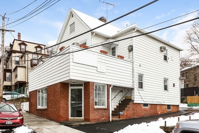

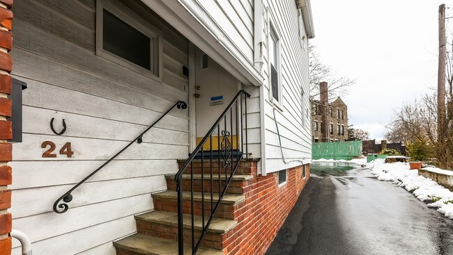
Property Detail
24 Smith St
1400-146-007-00003-000-0026
Westchester
Commercialofficeresidentialmixeduse
New York
B1
26.000
B and X Area of moderate flood hazard, usually the area between the limits of the 100-year and 500-year floods.
0.10 AC
2025
Rye
2025
Westchester/So Connecticut
007700
New York-Jersey City-White Plains, NY-NJ
2,583 SF
NEARBY LISTINGS FOR SALE OR LEASE
DEMOGRAPHICS near 24 Smith St
1 mile
3 mile
5 mile
2025 Total Population
10,238
79,542
157,751
2030 Population
10,391
78,982
158,817
Pop Growth 2025-2030
+ 1.49%
(0.70%)
+ 0.68%
Average Age
40
41
42
2025 Total Households
3,585
27,594
55,413
HH Growth 2025-2030
+ 1.51%
(0.67%)
+ 0.77%
Median Household Inc
$173,318
$138,477
$151,683
Avg Household Size
2.80
2.80
2.70
2025 Avg HH Vehicles
2.00
2.00
2.00
Median Home Value
$1,051,435
$883,499
$947,428
Median Year Built
1953
1956
1957
Nearby Places
Map Layers
Map Styles
 Street
 Aerial
Layers
 Traffic
 Biking
Places
Listings with unknown addresses are not visible on the map
- Restaurants
- Banks
- Shops
- Fitness
- Groceries
PUBLIC TRANSPORTATION
TRANSIT/SUBWAY
Rye Station (New Haven Line - Metro-North Commuter Railroad Company (Metro-North))
Drive
Walk
Distance
Rye Station (New Haven Line - Metro-North Commuter Railroad Company (Metro-North))
1 min
5 min
0.3 mi
COMMUTER RAIL
Rye Station (New Haven Line - Metro-North Commuter Railroad Company (Metro-North))
Drive
Walk
Distance
Rye Station (New Haven Line - Metro-North Commuter Railroad Company (Metro-North))
1 min
7 min
0.3 mi
Port Chester Station (New Haven Line - Metro-North Commuter Railroad Company (Metro-North))
Drive
Walk
Distance
Port Chester Station (New Haven Line - Metro-North Commuter Railroad Company (Metro-North))
4 min
1.9 mi
AIRPORT
Westchester County
Drive
Walk
Distance
Westchester County
15 min
10.2 mi
LaGuardia
Drive
Walk
Distance
LaGuardia
39 min
23.9 mi
John F Kennedy International
Drive
Walk
Distance
John F Kennedy International
45 min
31.5 mi
Freight Ports
NY - Red Hook Container Terminal
Drive
Walk
Distance
NY - Red Hook Container Terminal
53 min
34.4 mi
SALE & LEASE HISTORY
LISTING DATE
SALE/LEASE

Apr 09, 2018
For Sale
Nearby Properties
Address
Land Use
TOTAL SIZE
Lot Size
Zoning
Address
Land Use
TOTAL SIZE
Lot Size
Zoning
5COMMUND
Address
Land Use
TOTAL SIZE
Lot Size
Zoning
277,172 SF
29.98 AC
CD COMM
Address
Land Use
TOTAL SIZE
Lot Size
Zoning
9,828 SF
22.01 AC
R-6
Address
Land Use
TOTAL SIZE
Lot Size
Zoning
0.01 AC
5COMMUND
Address
Land Use
TOTAL SIZE
Lot Size
Zoning
5COMMUND
Address
Land Use
TOTAL SIZE
Lot Size
Zoning
345,927 SF
4.32 AC
MUR WTRFR
Address
Land Use
TOTAL SIZE
Lot Size
Zoning
556,297 SF
25.31 AC
05 - COMME
Address
Land Use
TOTAL SIZE
Lot Size
Zoning
5COMMUND
Address
Land Use
TOTAL SIZE
Lot Size
Zoning
91,202 SF
22.09 AC
R-6
Address
Land Use
TOTAL SIZE
Lot Size
Zoning
42,306 SF
20.35 AC
GB
Address
Land Use
TOTAL SIZE
Lot Size
Zoning
3.45 AC
RA-1
Address
Land Use
TOTAL SIZE
Lot Size
Zoning
143,372 SF
24.05 AC
OB-2 OFFC
Address
Land Use
TOTAL SIZE
Lot Size
Zoning
84,747 SF
8.64 AC
C1-P RTAIL
Address
Land Use
TOTAL SIZE
Lot Size
Zoning
135,380 SF
7.32 AC
MUR WTRFR
Address
Land Use
TOTAL SIZE
Lot Size
Zoning
158,232 SF
4.47 AC
GBO
Address
Land Use
TOTAL SIZE
Lot Size
Zoning
126,404 SF
1.12 AC
GBO
Address
Land Use
TOTAL SIZE
Lot Size
Zoning
9.30 AC
M2 INDUST
Address
Land Use
TOTAL SIZE
Lot Size
Zoning
122,386 SF
1.39 AC
DW2 WTRFR
Address
Land Use
TOTAL SIZE
Lot Size
Zoning
65,659 SF
7.72 AC
R-6
Address
Land Use
TOTAL SIZE
Lot Size
Zoning
101,657 SF
1.14 AC
C2 COMM
Address
Land Use
TOTAL SIZE
Lot Size
Zoning
107,754 SF
3.22 AC
GBO
Address
Land Use
TOTAL SIZE
Lot Size
Zoning
171,925 SF
6.21 AC
M2 INDUST
Address
Land Use
TOTAL SIZE
Lot Size
Zoning
6.31 AC
R-5 SFR
Address
Land Use
TOTAL SIZE
Lot Size
Zoning
9,756 SF
13.07 AC
R-6
Address
Land Use
TOTAL SIZE
Lot Size
Zoning
104,048 SF
1.71 AC
GBO
Address
Land Use
TOTAL SIZE
Lot Size
Zoning
75,598 SF
0.54 AC
MUR WTRFR
Address
Land Use
TOTAL SIZE
Lot Size
Zoning
10.10 AC
RA-1
Address
Land Use
TOTAL SIZE
Lot Size
Zoning
109,212 SF
1.80 AC
CD COMM
Address
Land Use
TOTAL SIZE
Lot Size
Zoning
88,900 SF
0.51 AC
MUR WTRFR
Address
Land Use
TOTAL SIZE
Lot Size
Zoning
123,454 SF
1.54 AC
M2 INDUST
The World's #1 Commercial Real Estate Marketplace
Connect with us
© 2026 CoStar Group
The information above has been obtained from sources believed reliable. While we do not doubt its accuracy we have not verified it and make no guarantee, warranty or representation about it. It is your responsibility to independently confirm its accuracy and completeness. Any projections, opinions, assumptions, or estimates used are for example only and do not represent the current or future performance of the property. The value of this transaction to you depends on tax and other factors which should be evaluated by your tax, financial, and legal advisors. You and your advisors should conduct a careful, independent investigation of the property to determine to your satisfaction the suitability of the property for your needs.