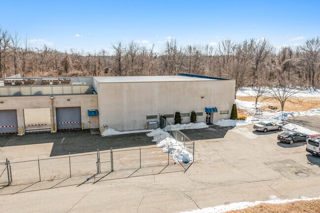
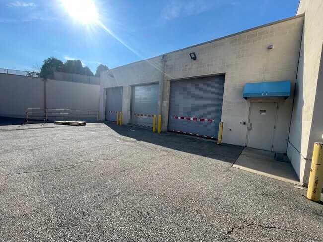
Property Record
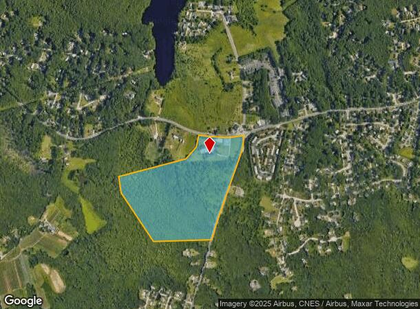
24 Snake Hill Rd, North Scituate, RI 02857
NEARBY LISTINGS FOR SALE OR LEASE
-
-
View all North Scituate listings for lease on LoopNet.com
Property Detail
24 Snake Hill Rd
Commercialbuilding
Providence
A
Rhode Island
44007C0277G
52 AC
2025
Burrillville/Glocester
2025
Providence
013102
Providence-Warwick, RI-MA
19,473 SF
GLOC-000019-000000-000124
DEMOGRAPHICS near 24 Snake Hill Rd
1 Mile
3 Mile
5 Mile
2024 Total Population
2,844
17,824
47,728
2029 Population
2,861
18,014
48,041
Pop Growth 2024-2029
+ 0.60%
+ 1.07%
+ 0.66%
Average Age
46
46
44
2024 Total Households
1,208
6,844
18,298
HH Growth 2024-2029
+ 0.50%
+ 1.05%
+ 0.64%
Median Household Inc
$101,446
$105,685
$98,196
Avg Household Size
2.30
2.50
2.40
2024 Avg HH Vehicles
2.00
2.00
2.00
Median Home Value
$386,568
$387,850
$368,225
Median Year Built
1970
1973
1972
Nearby Places
Map Layers
Map Styles
 Street
 Aerial
- Restaurants
- Banks
- Shops
- Fitness
- Groceries
PUBLIC TRANSPORTATION
AIRPORT
Rhode Island Tf Green International
DRIVE
WALK
Distance
Rhode Island Tf Green International
27 min
17.1 mi
Worcester Regional
DRIVE
WALK
Distance
Worcester Regional
60 min
41.8 mi
Freight Ports
Port of Davisville, RI
DRIVE
WALK
Distance
Port of Davisville, RI
39 min
26.4 mi
SALE & LEASE HISTORY
LISTING DATE
SALE/LEASE

May 14, 2024
For Lease
Apr 19, 2022
For Sale
Nearby Properties
Address
Land Use
TOTAL SIZE
Lot Size
Zoning
Address
Land Use
TOTAL SIZE
Lot Size
Zoning
166,368 SF
10.74 AC
R20
Address
Land Use
TOTAL SIZE
Lot Size
Zoning
31.11 AC
R20M
Address
Land Use
TOTAL SIZE
Lot Size
Zoning
89,788 SF
11.25 AC
R20
Address
Land Use
TOTAL SIZE
Lot Size
Zoning
72,531 SF
11.70 AC
R20
Address
Land Use
TOTAL SIZE
Lot Size
Zoning
9.59 AC
MU
Address
Land Use
TOTAL SIZE
Lot Size
Zoning
87,649 SF
8 AC
R20
Address
Land Use
TOTAL SIZE
Lot Size
Zoning
78,346 SF
10.75 AC
PD
Address
Land Use
TOTAL SIZE
Lot Size
Zoning
85,130 SF
4.40 AC
R20
Address
Land Use
TOTAL SIZE
Lot Size
Zoning
40.40 AC
RS-1
Address
Land Use
TOTAL SIZE
Lot Size
Zoning
96,723 SF
21.69 AC
PD
Address
Land Use
TOTAL SIZE
Lot Size
Zoning
1 AC
PD
Address
Land Use
TOTAL SIZE
Lot Size
Zoning
60,658 SF
11.40 AC
MU
Address
Land Use
TOTAL SIZE
Lot Size
Zoning
40,586 SF
3.40 AC
RS-1
Address
Land Use
TOTAL SIZE
Lot Size
Zoning
33,340 SF
5 AC
PD
Address
Land Use
TOTAL SIZE
Lot Size
Zoning
30,275 SF
1.42 AC
MU
Address
Land Use
TOTAL SIZE
Lot Size
Zoning
1.81 AC
V
Address
Land Use
TOTAL SIZE
Lot Size
Zoning
36,973 SF
4.71 AC
R20
Address
Land Use
TOTAL SIZE
Lot Size
Zoning
29,840 SF
4.59 AC
PD
Address
Land Use
TOTAL SIZE
Lot Size
Zoning
67,142 SF
3.48 AC
I
Address
Land Use
TOTAL SIZE
Lot Size
Zoning
50,886 SF
5.28 AC
BG
Address
Land Use
TOTAL SIZE
Lot Size
Zoning
28,866 SF
3.36 AC
PD
Address
Land Use
TOTAL SIZE
Lot Size
Zoning
2.37 AC
V
Address
Land Use
TOTAL SIZE
Lot Size
Zoning
17.99 AC
I
Address
Land Use
TOTAL SIZE
Lot Size
Zoning
53,824 SF
3.13 AC
V
Address
Land Use
TOTAL SIZE
Lot Size
Zoning
14,856 SF
2.58 AC
PD
Address
Land Use
TOTAL SIZE
Lot Size
Zoning
32,631 SF
2.32 AC
PD
Address
Land Use
TOTAL SIZE
Lot Size
Zoning
11,436 SF
95.42 AC
R20
Address
Land Use
TOTAL SIZE
Lot Size
Zoning
5.13 AC
V
Address
Land Use
TOTAL SIZE
Lot Size
Zoning
29,320 SF
0.52 AC
C
Address
Land Use
TOTAL SIZE
Lot Size
Zoning
19,244 SF
0.70 AC
RS-1
The World's #1 Commercial Real Estate Marketplace
Connect with us
© 2025 CoStar Group
The information above has been obtained from sources believed reliable. While we do not doubt its accuracy we have not verified it and make no guarantee, warranty or representation about it. It is your responsibility to independently confirm its accuracy and completeness. Any projections, opinions, assumptions, or estimates used are for example only and do not represent the current or future performance of the property. The value of this transaction to you depends on tax and other factors which should be evaluated by your tax, financial, and legal advisors. You and your advisors should conduct a careful, independent investigation of the property to determine to your satisfaction the suitability of the property for your needs.