Property Record
10 Stemmers Run Rd, Essex, MD 21221
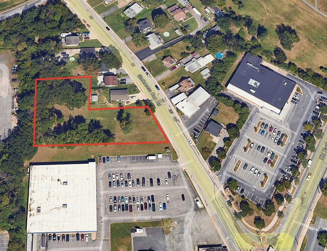

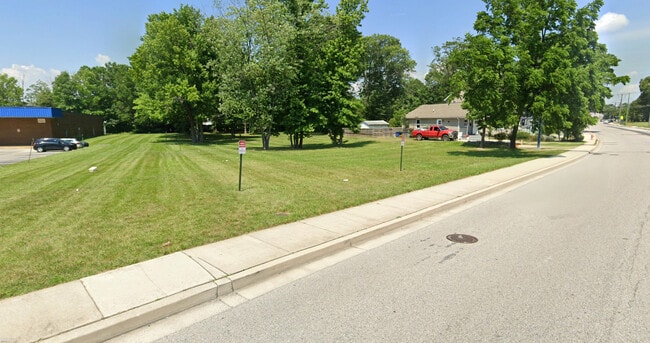
This Property Is For Sale
Property Detail
10 Stemmers Run Rd
15-1600014512
2.8528 AC
Supermarket
Baltimore
BMCNS
Maryland
B and X Area of moderate flood hazard, usually the area between the limits of the 100-year and 500-year floods.
2.86 AC
2024
Baltimore County East
2025
Baltimore
450501
Baltimore-Columbia-Towson, MD
24,000 SF
NEARBY LISTINGS FOR SALE OR LEASE
DEMOGRAPHICS near 10 Stemmers Run Rd
1 mile
3 mile
5 mile
2025 Total Population
20,067
78,553
201,130
2030 Population
20,148
78,902
201,438
Pop Growth 2025-2030
+ 0.40%
+ 0.44%
+ 0.15%
Average Age
40
40
40
2025 Total Households
8,100
30,598
77,233
HH Growth 2025-2030
+ 0.52%
+ 0.54%
+ 0.16%
Median Household Inc
$59,347
$68,852
$73,111
Avg Household Size
2.40
2.50
2.50
2025 Avg HH Vehicles
1.00
2.00
2.00
Median Home Value
$235,651
$275,327
$262,414
Median Year Built
1959
1970
1965
Nearby Places
Map Layers
Map Styles
 Street
 Aerial
Layers
 Traffic
 Biking
Places
Listings with unknown addresses are not visible on the map
- Restaurants
- Banks
- Shops
- Fitness
- Groceries
PUBLIC TRANSPORTATION
COMMUTER RAIL
Drive
Walk
Distance
7 min
2.6 mi
AIRPORT
Baltimore/Washington International Thurgood Marshall
Drive
Walk
Distance
Baltimore/Washington International Thurgood Marshall
35 min
22.2 mi
Freight Ports
Port of Baltimore
Drive
Walk
Distance
Port of Baltimore
23 min
10.8 mi
Nearby Properties
Address
Land Use
TOTAL SIZE
Lot Size
Zoning
Address
Land Use
TOTAL SIZE
Lot Size
Zoning
159,728 SF
0.02 AC
MH
Address
Land Use
TOTAL SIZE
Lot Size
Zoning
85,474 SF
22.22 AC
Address
Land Use
TOTAL SIZE
Lot Size
Zoning
21.74 AC
DR16
Address
Land Use
TOTAL SIZE
Lot Size
Zoning
1,062,672 SF
70.27 AC
MHIM
Address
Land Use
TOTAL SIZE
Lot Size
Zoning
15.40 AC
DR16
Address
Land Use
TOTAL SIZE
Lot Size
Zoning
507,600 SF
21.36 AC
MHIM
Address
Land Use
TOTAL SIZE
Lot Size
Zoning
14.28 AC
DR16
Address
Land Use
TOTAL SIZE
Lot Size
Zoning
271,370 SF
20.11 AC
BM
Address
Land Use
TOTAL SIZE
Lot Size
Zoning
117,170 SF
7.84 AC
BM
Address
Land Use
TOTAL SIZE
Lot Size
Zoning
253,081 SF
42.21 AC
DR5.5
Address
Land Use
TOTAL SIZE
Lot Size
Zoning
300,400 SF
31.60 AC
ML-IM
Address
Land Use
TOTAL SIZE
Lot Size
Zoning
135,931 SF
21.65 AC
DR5.5
Address
Land Use
TOTAL SIZE
Lot Size
Zoning
192 SF
11.09 AC
Address
Land Use
TOTAL SIZE
Lot Size
Zoning
23.40 AC
DR16
Address
Land Use
TOTAL SIZE
Lot Size
Zoning
97,878 SF
12.45 AC
DR5.5
Address
Land Use
TOTAL SIZE
Lot Size
Zoning
158,131 SF
13.02 AC
BM
Address
Land Use
TOTAL SIZE
Lot Size
Zoning
20.13 AC
DR16
Address
Land Use
TOTAL SIZE
Lot Size
Zoning
14.30 AC
DR16
Address
Land Use
TOTAL SIZE
Lot Size
Zoning
19 AC
DR16
Address
Land Use
TOTAL SIZE
Lot Size
Zoning
24.95 AC
DR16
Address
Land Use
TOTAL SIZE
Lot Size
Zoning
12.47 AC
DR16
Address
Land Use
TOTAL SIZE
Lot Size
Zoning
126,096 SF
14.68 AC
DR105
Address
Land Use
TOTAL SIZE
Lot Size
Zoning
81,300 SF
3.92 AC
Address
Land Use
TOTAL SIZE
Lot Size
Zoning
10.48 AC
DR16
Address
Land Use
TOTAL SIZE
Lot Size
Zoning
10.53 AC
DR16
Address
Land Use
TOTAL SIZE
Lot Size
Zoning
130,797 SF
18.11 AC
DR105
Address
Land Use
TOTAL SIZE
Lot Size
Zoning
237,925 SF
28.28 AC
Address
Land Use
TOTAL SIZE
Lot Size
Zoning
294,750 SF
16.51 AC
ML-IM
Address
Land Use
TOTAL SIZE
Lot Size
Zoning
12.25 AC
DR16
Address
Land Use
TOTAL SIZE
Lot Size
Zoning
1,914,359 SF
24.44 AC
MHIM
The World's #1 Commercial Real Estate Marketplace
Connect with us
© 2026 CoStar Group
The information above has been obtained from sources believed reliable. While we do not doubt its accuracy we have not verified it and make no guarantee, warranty or representation about it. It is your responsibility to independently confirm its accuracy and completeness. Any projections, opinions, assumptions, or estimates used are for example only and do not represent the current or future performance of the property. The value of this transaction to you depends on tax and other factors which should be evaluated by your tax, financial, and legal advisors. You and your advisors should conduct a careful, independent investigation of the property to determine to your satisfaction the suitability of the property for your needs.