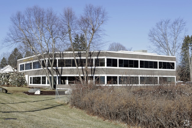
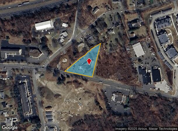
Property Record
24 Stony Hill Rd, Bethel, CT 06801
Current Lease Availabilities
NEARBY LISTINGS FOR SALE OR LEASE
Property Detail
24 Stony Hill Rd
BETH-000071-000109-000012
Fairfield
Officebuilding
Connecticut
X
12
09001C0142F
1.11 AC
2024
Bethel
2025
Westchester/So Connecticut
200301
Bridgeport-Stamford-Danbury, CT
12,920 SF
DEMOGRAPHICS near 24 Stony Hill Rd
1 Mile
3 Mile
5 Mile
2024 Total Population
4,613
42,442
113,232
2029 Population
4,657
42,526
112,956
Pop Growth 2024-2029
+ 0.95%
+ 0.20%
(0.24%)
Average Age
43
42
40
2024 Total Households
1,637
15,942
41,212
HH Growth 2024-2029
+ 0.92%
+ 0.11%
(0.32%)
Median Household Inc
$134,214
$99,838
$88,639
Avg Household Size
2.60
2.60
2.60
2024 Avg HH Vehicles
2.00
2.00
2.00
Median Home Value
$360,865
$356,476
$366,109
Median Year Built
1975
1977
1972
Nearby Places
Map Layers
Map Styles
 Street
 Aerial
- Restaurants
- Banks
- Shops
- Fitness
- Groceries
PUBLIC TRANSPORTATION
COMMUTER RAIL
Danbury Station (New Haven Line - Metro-North Commuter Railroad Company (Metro-North))
DRIVE
WALK
Distance
Danbury Station (New Haven Line - Metro-North Commuter Railroad Company (Metro-North))
9 min
3.7 mi
Bethel Station (New Haven Line - Metro-North Commuter Railroad Company (Metro-North))
DRIVE
WALK
Distance
Bethel Station (New Haven Line - Metro-North Commuter Railroad Company (Metro-North))
12 min
5.6 mi
AIRPORT
Tweed/New Haven
DRIVE
WALK
Distance
Tweed/New Haven
55 min
35.0 mi
Westchester County
DRIVE
WALK
Distance
Westchester County
49 min
37.9 mi
Nearby Properties
Address
Land Use
TOTAL SIZE
Lot Size
Zoning
Address
Land Use
TOTAL SIZE
Lot Size
Zoning
297,318 SF
18.16 AC
IG80
Address
Land Use
TOTAL SIZE
Lot Size
Zoning
86,646 SF
122.26 AC
R-40
Address
Land Use
TOTAL SIZE
Lot Size
Zoning
7,769 SF
17.75 AC
RA-20
Address
Land Use
TOTAL SIZE
Lot Size
Zoning
36.22 AC
RA-20
Address
Land Use
TOTAL SIZE
Lot Size
Zoning
168,282 SF
22.83 AC
R-60
Address
Land Use
TOTAL SIZE
Lot Size
Zoning
322,970 SF
43.80 AC
IP
Address
Land Use
TOTAL SIZE
Lot Size
Zoning
33.50 AC
CG-20
Address
Land Use
TOTAL SIZE
Lot Size
Zoning
95,976 SF
4.14 AC
RH3
Address
Land Use
TOTAL SIZE
Lot Size
Zoning
31.57 AC
C-1
Address
Land Use
TOTAL SIZE
Lot Size
Zoning
42.36 AC
R-3
Address
Land Use
TOTAL SIZE
Lot Size
Zoning
20.49 AC
R-2
Address
Land Use
TOTAL SIZE
Lot Size
Zoning
7.28 AC
RH3
Address
Land Use
TOTAL SIZE
Lot Size
Zoning
12.51 AC
IL40
Address
Land Use
TOTAL SIZE
Lot Size
Zoning
139,231 SF
13.31 AC
CP
Address
Land Use
TOTAL SIZE
Lot Size
Zoning
49.57 AC
CG-20
Address
Land Use
TOTAL SIZE
Lot Size
Zoning
172,288 SF
14.99 AC
IL40
Address
Land Use
TOTAL SIZE
Lot Size
Zoning
4.09 AC
C-1
Address
Land Use
TOTAL SIZE
Lot Size
Zoning
9.39 AC
C-2
Address
Land Use
TOTAL SIZE
Lot Size
Zoning
Address
Land Use
TOTAL SIZE
Lot Size
Zoning
111,660 SF
8.99 AC
CG20
Address
Land Use
TOTAL SIZE
Lot Size
Zoning
16.31 AC
C-1
Address
Land Use
TOTAL SIZE
Lot Size
Zoning
92,843 SF
9.74 AC
CG20
Address
Land Use
TOTAL SIZE
Lot Size
Zoning
3.08 AC
CG-20
Address
Land Use
TOTAL SIZE
Lot Size
Zoning
123,271 SF
16.06 AC
C-1
Address
Land Use
TOTAL SIZE
Lot Size
Zoning
7.85 AC
RA-20
Address
Land Use
TOTAL SIZE
Lot Size
Zoning
92,204 SF
10.77 AC
RT 6
Address
Land Use
TOTAL SIZE
Lot Size
Zoning
2.86 AC
RH3
Address
Land Use
TOTAL SIZE
Lot Size
Zoning
56,658 SF
12 AC
RA40
Address
Land Use
TOTAL SIZE
Lot Size
Zoning
279,236 SF
12.10 AC
IG80
Address
Land Use
TOTAL SIZE
Lot Size
Zoning
127,863 SF
12.82 AC
R-20
The World's #1 Commercial Real Estate Marketplace
Connect with us
© 2026 CoStar Group
The information above has been obtained from sources believed reliable. While we do not doubt its accuracy we have not verified it and make no guarantee, warranty or representation about it. It is your responsibility to independently confirm its accuracy and completeness. Any projections, opinions, assumptions, or estimates used are for example only and do not represent the current or future performance of the property. The value of this transaction to you depends on tax and other factors which should be evaluated by your tax, financial, and legal advisors. You and your advisors should conduct a careful, independent investigation of the property to determine to your satisfaction the suitability of the property for your needs.