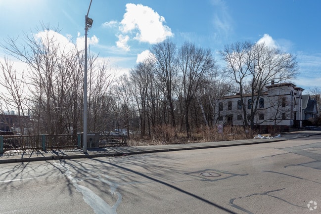
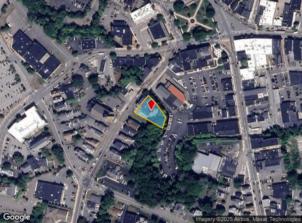
Property Record
24 Winthrop St, Taunton, MA 02780


NEARBY LISTINGS FOR SALE OR LEASE
Property Detail
24 Winthrop St
TAUN-000066-000560
Bristol
Apartment
Massachusetts
AE
560
25005C0163G
0.23 AC
2025
Attleboro/New Bedford
2025
Boston
613800
Providence-Warwick, RI-MA
18,216 SF
DEMOGRAPHICS near 24 Winthrop St
1 Mile
3 Mile
5 Mile
2024 Total Population
15,492
47,721
79,903
2029 Population
15,335
47,173
79,258
Pop Growth 2024-2029
(1.01%)
(1.15%)
(0.81%)
Average Age
39
41
41
2024 Total Households
6,605
19,386
31,258
HH Growth 2024-2029
(1.00%)
(1.18%)
(0.86%)
Median Household Inc
$43,997
$59,182
$75,964
Avg Household Size
2.20
2.40
2.50
2024 Avg HH Vehicles
1.00
2.00
2.00
Median Home Value
$352,739
$354,510
$378,993
Median Year Built
1948
1960
1972
Nearby Places
Map Layers
Map Styles
 Street
 Aerial
- Restaurants
- Banks
- Shops
- Fitness
- Groceries
PUBLIC TRANSPORTATION
AIRPORT
Rhode Island Tf Green International
DRIVE
WALK
Distance
Rhode Island Tf Green International
44 min
25.6 mi
General Edward Lawrence Logan International
DRIVE
WALK
Distance
General Edward Lawrence Logan International
55 min
40.7 mi
Freight Ports
Port of New Bedford Harbor
DRIVE
WALK
Distance
Port of New Bedford Harbor
32 min
23.0 mi
SALE & LEASE HISTORY
LISTING DATE
SALE/LEASE

Jul 12, 2017
For Sale
Nearby Properties
Address
Land Use
TOTAL SIZE
Lot Size
Zoning
Address
Land Use
TOTAL SIZE
Lot Size
Zoning
68,024 SF
66.24 AC
RURRES
Address
Land Use
TOTAL SIZE
Lot Size
Zoning
279,756 SF
11.62 AC
OFFDIS
Address
Land Use
TOTAL SIZE
Lot Size
Zoning
130,851 SF
24.43 AC
URBRES
Address
Land Use
TOTAL SIZE
Lot Size
Zoning
133,652 SF
2 AC
Address
Land Use
TOTAL SIZE
Lot Size
Zoning
147,285 SF
0.79 AC
CENBIZ
Address
Land Use
TOTAL SIZE
Lot Size
Zoning
157.20 AC
OPSPAC
Address
Land Use
TOTAL SIZE
Lot Size
Zoning
486,363 SF
41.18 AC
INDUST
Address
Land Use
TOTAL SIZE
Lot Size
Zoning
217,011 SF
73.55 AC
OPSPAC
Address
Land Use
TOTAL SIZE
Lot Size
Zoning
27 AC
INDUST
Address
Land Use
TOTAL SIZE
Lot Size
Zoning
37.62 AC
URBRES
Address
Land Use
TOTAL SIZE
Lot Size
Zoning
39,910 SF
1.05 AC
CENBIZ
Address
Land Use
TOTAL SIZE
Lot Size
Zoning
14.43 AC
Address
Land Use
TOTAL SIZE
Lot Size
Zoning
351,320 SF
42 AC
INDUST
Address
Land Use
TOTAL SIZE
Lot Size
Zoning
5.20 AC
URBRES
Address
Land Use
TOTAL SIZE
Lot Size
Zoning
52,042 SF
59.53 AC
OPSPAC
Address
Land Use
TOTAL SIZE
Lot Size
Zoning
127,092 SF
9.37 AC
INDUST
Address
Land Use
TOTAL SIZE
Lot Size
Zoning
6.53 AC
URBRES
Address
Land Use
TOTAL SIZE
Lot Size
Zoning
45,786 SF
16 AC
URBRES
Address
Land Use
TOTAL SIZE
Lot Size
Zoning
36,336 SF
6.35 AC
RURRES
Address
Land Use
TOTAL SIZE
Lot Size
Zoning
16 AC
URBRES
Address
Land Use
TOTAL SIZE
Lot Size
Zoning
8,000 SF
22.31 AC
Address
Land Use
TOTAL SIZE
Lot Size
Zoning
124,465 SF
15.08 AC
INDUST
Address
Land Use
TOTAL SIZE
Lot Size
Zoning
163,752 SF
28.17 AC
INDUST
Address
Land Use
TOTAL SIZE
Lot Size
Zoning
44,581 SF
14.60 AC
RURRES
Address
Land Use
TOTAL SIZE
Lot Size
Zoning
61,128 SF
0.98 AC
Address
Land Use
TOTAL SIZE
Lot Size
Zoning
107,794 SF
12.51 AC
Address
Land Use
TOTAL SIZE
Lot Size
Zoning
13 AC
HIWABZ
Address
Land Use
TOTAL SIZE
Lot Size
Zoning
96,208 SF
1.70 AC
URBRES
Address
Land Use
TOTAL SIZE
Lot Size
Zoning
3 AC
URBRES
Address
Land Use
TOTAL SIZE
Lot Size
Zoning
5.60 AC
INDUST
The World's #1 Commercial Real Estate Marketplace
Connect with us
© 2025 CoStar Group
The information above has been obtained from sources believed reliable. While we do not doubt its accuracy we have not verified it and make no guarantee, warranty or representation about it. It is your responsibility to independently confirm its accuracy and completeness. Any projections, opinions, assumptions, or estimates used are for example only and do not represent the current or future performance of the property. The value of this transaction to you depends on tax and other factors which should be evaluated by your tax, financial, and legal advisors. You and your advisors should conduct a careful, independent investigation of the property to determine to your satisfaction the suitability of the property for your needs.