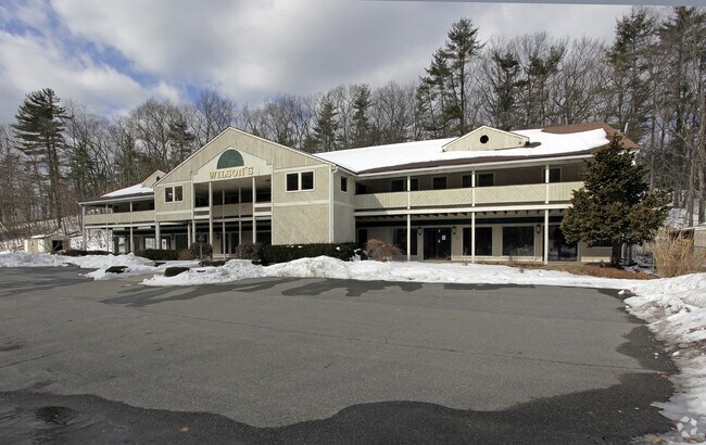
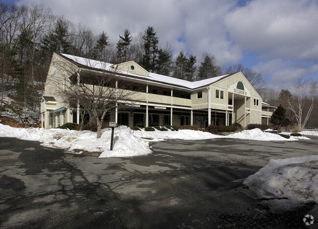
Property Record
240 Central St, Berlin, MA 01503

Save to a Folder
{{folder.Name}}
{{folder.ListingIds.length}} Properties
{{folder.ListingIds.length}} Property
Create a New Folder
Property Detail
240 Central St
BERL-000160-000012
Worcester
Storebuilding
Massachusetts
B and X Area of moderate flood hazard, usually the area between the limits of the 100-year and 500-year floods.
2 AC
2025
Outlying Worcester
2025
Boston
717100
Worcester, MA
15,000 SF
NEARBY LISTINGS FOR SALE OR LEASE
DEMOGRAPHICS near 240 Central St
1 mile
3 mile
5 mile
2025 Total Population
400
22,975
82,180
2030 Population
422
23,844
84,863
Pop Growth 2025-2030
+ 5.50%
+ 3.78%
+ 3.26%
Average Age
44
43
42
2025 Total Households
154
9,388
32,421
HH Growth 2025-2030
+ 5.84%
+ 3.86%
+ 3.35%
Median Household Inc
$124,999
$108,287
$110,449
Avg Household Size
2.60
2.40
2.50
2025 Avg HH Vehicles
2.00
2.00
2.00
Median Home Value
$709,459
$535,657
$541,406
Median Year Built
1998
1976
1970
Nearby Places
Map Layers
Map Styles
 Street
 Aerial
Layers
 Traffic
 Biking
Places
Listings with unknown addresses are not visible on the map
- Restaurants
- Banks
- Shops
- Fitness
- Groceries
PUBLIC TRANSPORTATION
AIRPORT
Worcester Regional
Drive
Walk
Distance
Worcester Regional
31 min
21.2 mi
Freight Ports
Port of Boston
Drive
Walk
Distance
Port of Boston
53 min
40.3 mi
Nearby Properties
Address
Land Use
TOTAL SIZE
Lot Size
Zoning
Address
Land Use
TOTAL SIZE
Lot Size
Zoning
71.70 AC
LI
Address
Land Use
TOTAL SIZE
Lot Size
Zoning
13.86 AC
SB
Address
Land Use
TOTAL SIZE
Lot Size
Zoning
54.67 AC
LI
Address
Land Use
TOTAL SIZE
Lot Size
Zoning
14.80 AC
M6
Address
Land Use
TOTAL SIZE
Lot Size
Zoning
121,434 SF
21.35 AC
SA8
Address
Land Use
TOTAL SIZE
Lot Size
Zoning
91,722 SF
8.38 AC
A2
Address
Land Use
TOTAL SIZE
Lot Size
Zoning
12.42 AC
M1
Address
Land Use
TOTAL SIZE
Lot Size
Zoning
209,220 SF
19.33 AC
I
Address
Land Use
TOTAL SIZE
Lot Size
Zoning
118,126 SF
82.89 AC
Address
Land Use
TOTAL SIZE
Lot Size
Zoning
283,750 SF
27.03 AC
LI
Address
Land Use
TOTAL SIZE
Lot Size
Zoning
47,301 SF
8.07 AC
Address
Land Use
TOTAL SIZE
Lot Size
Zoning
199,892 SF
46.51 AC
Address
Land Use
TOTAL SIZE
Lot Size
Zoning
119,850 SF
49.66 AC
LC1
Address
Land Use
TOTAL SIZE
Lot Size
Zoning
120,146 SF
7.33 AC
LI
Address
Land Use
TOTAL SIZE
Lot Size
Zoning
182,509 SF
11.35 AC
A2
Address
Land Use
TOTAL SIZE
Lot Size
Zoning
278,442 SF
5.68 AC
I
Address
Land Use
TOTAL SIZE
Lot Size
Zoning
32,082 SF
3.70 AC
Address
Land Use
TOTAL SIZE
Lot Size
Zoning
9.90 AC
C12
Address
Land Use
TOTAL SIZE
Lot Size
Zoning
75,542 SF
3.23 AC
SB
Address
Land Use
TOTAL SIZE
Lot Size
Zoning
8.51 AC
LI
Address
Land Use
TOTAL SIZE
Lot Size
Zoning
80,722 SF
27.01 AC
SA8
Address
Land Use
TOTAL SIZE
Lot Size
Zoning
10 AC
SA8
Address
Land Use
TOTAL SIZE
Lot Size
Zoning
11.17 AC
LI
Address
Land Use
TOTAL SIZE
Lot Size
Zoning
16.51 AC
SA7
Address
Land Use
TOTAL SIZE
Lot Size
Zoning
104,752 SF
7.54 AC
C11
Address
Land Use
TOTAL SIZE
Lot Size
Zoning
88.13 AC
LI
Address
Land Use
TOTAL SIZE
Lot Size
Zoning
238,303 SF
25 AC
LI
Address
Land Use
TOTAL SIZE
Lot Size
Zoning
138,734 SF
16.03 AC
LCI1
Address
Land Use
TOTAL SIZE
Lot Size
Zoning
112,672 SF
16.50 AC
LI
Address
Land Use
TOTAL SIZE
Lot Size
Zoning
134,550 SF
19.76 AC
R1
The World's #1 Commercial Real Estate Marketplace
Connect with us
© 2026 CoStar Group
The information above has been obtained from sources believed reliable. While we do not doubt its accuracy we have not verified it and make no guarantee, warranty or representation about it. It is your responsibility to independently confirm its accuracy and completeness. Any projections, opinions, assumptions, or estimates used are for example only and do not represent the current or future performance of the property. The value of this transaction to you depends on tax and other factors which should be evaluated by your tax, financial, and legal advisors. You and your advisors should conduct a careful, independent investigation of the property to determine to your satisfaction the suitability of the property for your needs.