Property Record
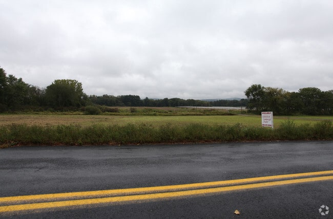
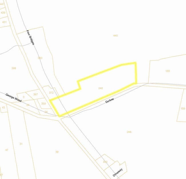
240 Durkee Rd, Somers, CT 06071

Property Detail
240 Durkee Rd
SOME-000007-000055-000007
TOLLAND
Residentialacreage
Connecticut
A-1
7
A Areas with a 1% annual chance of flooding and a 26% chance of flooding over the life of a 30-year mortgage.
2.96 AC
2025
Tolland County
2025
Hartford
538201
Hartford-West Hartford-East Hartford, CT
NEARBY LISTINGS FOR SALE OR LEASE
-
-
View all Somers listings for sale on LoopNet.com
DEMOGRAPHICS near 240 Durkee Rd
1 mile
3 mile
5 mile
2025 Total Population
1,165
14,802
46,984
2030 Population
1,190
15,112
47,760
Pop Growth 2025-2030
+ 2.15%
+ 2.09%
+ 1.65%
Average Age
45
44
44
2025 Total Households
436
4,871
17,942
HH Growth 2025-2030
+ 2.06%
+ 2.16%
+ 1.71%
Median Household Inc
$111,923
$110,860
$106,120
Avg Household Size
2.70
2.50
2.40
2025 Avg HH Vehicles
2.00
2.00
2.00
Median Home Value
$371,655
$359,762
$334,172
Median Year Built
1973
1971
1968
Nearby Places
Map Layers
Map Styles
 Street
 Aerial
Layers
 Traffic
 Biking
Places
Listings with unknown addresses are not visible on the map
- Restaurants
- Banks
- Shops
- Fitness
- Groceries
PUBLIC TRANSPORTATION
AIRPORT
Bradley International
Drive
Walk
Distance
Bradley International
32 min
15.4 mi
Freight Ports
Port of New Haven
Drive
Walk
Distance
Port of New Haven
85 min
63.9 mi
Nearby Properties
Address
Land Use
TOTAL SIZE
Lot Size
Zoning
Address
Land Use
TOTAL SIZE
Lot Size
Zoning
750,000 SF
405 AC
A-1
Address
Land Use
TOTAL SIZE
Lot Size
Zoning
226,545 SF
14 AC
A-1
Address
Land Use
TOTAL SIZE
Lot Size
Zoning
370.78 AC
R88
Address
Land Use
TOTAL SIZE
Lot Size
Zoning
283.30 AC
R88
Address
Land Use
TOTAL SIZE
Lot Size
Zoning
108.50 AC
A-1
Address
Land Use
TOTAL SIZE
Lot Size
Zoning
49.16 AC
I-1
Address
Land Use
TOTAL SIZE
Lot Size
Zoning
36.97 AC
I-1
Address
Land Use
TOTAL SIZE
Lot Size
Zoning
121 AC
A-1
Address
Land Use
TOTAL SIZE
Lot Size
Zoning
78,835 SF
5.94 AC
Address
Land Use
TOTAL SIZE
Lot Size
Zoning
152.20 AC
A-1
Address
Land Use
TOTAL SIZE
Lot Size
Zoning
104,111 SF
11.16 AC
I-1
Address
Land Use
TOTAL SIZE
Lot Size
Zoning
90,776 SF
23.48 AC
I-1
Address
Land Use
TOTAL SIZE
Lot Size
Zoning
169,680 SF
11.49 AC
I-1
Address
Land Use
TOTAL SIZE
Lot Size
Zoning
47,756 SF
6.17 AC
R33
Address
Land Use
TOTAL SIZE
Lot Size
Zoning
9,948 SF
77.88 AC
A
Address
Land Use
TOTAL SIZE
Lot Size
Zoning
67.24 AC
R88
Address
Land Use
TOTAL SIZE
Lot Size
Zoning
20.56 AC
MF
Address
Land Use
TOTAL SIZE
Lot Size
Zoning
2.20 AC
A-1
Address
Land Use
TOTAL SIZE
Lot Size
Zoning
8.10 AC
B
Address
Land Use
TOTAL SIZE
Lot Size
Zoning
16,282 SF
11 AC
A-1
Address
Land Use
TOTAL SIZE
Lot Size
Zoning
2,746 SF
45.08 AC
R88
Address
Land Use
TOTAL SIZE
Lot Size
Zoning
18.66 AC
Address
Land Use
TOTAL SIZE
Lot Size
Zoning
20,208 SF
2 AC
A-1
Address
Land Use
TOTAL SIZE
Lot Size
Zoning
75,072 SF
25.39 AC
I-1
Address
Land Use
TOTAL SIZE
Lot Size
Zoning
10,980 SF
15.10 AC
I-1
Address
Land Use
TOTAL SIZE
Lot Size
Zoning
150,018 SF
7.89 AC
I-1
Address
Land Use
TOTAL SIZE
Lot Size
Zoning
38,340 SF
5.14 AC
I-1
Address
Land Use
TOTAL SIZE
Lot Size
Zoning
37,656 SF
10.42 AC
A-1
Address
Land Use
TOTAL SIZE
Lot Size
Zoning
6.17 AC
I-1
Address
Land Use
TOTAL SIZE
Lot Size
Zoning
52,164 SF
4.30 AC
I-1
The World's #1 Commercial Real Estate Marketplace
Connect with us
© 2026 CoStar Group
The information above has been obtained from sources believed reliable. While we do not doubt its accuracy we have not verified it and make no guarantee, warranty or representation about it. It is your responsibility to independently confirm its accuracy and completeness. Any projections, opinions, assumptions, or estimates used are for example only and do not represent the current or future performance of the property. The value of this transaction to you depends on tax and other factors which should be evaluated by your tax, financial, and legal advisors. You and your advisors should conduct a careful, independent investigation of the property to determine to your satisfaction the suitability of the property for your needs.