Property Record
240 Grant St Se, Atlanta, GA 30312

NEARBY LISTINGS FOR SALE OR LEASE
Property Detail
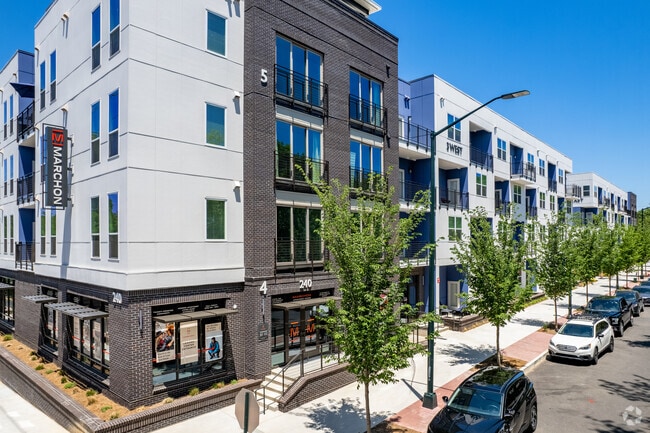
240 Grant St Se
Atlanta-Sandy Springs-Roswell, GA
KA MARCHON APARTMENTS FLD CK 5/2/22; N/C APTS 100% COMPL 26CB: REMOVE HOF OVERRIDE IMPROVEMENT ONLY PARCEL ** SEE NOTES
14-0045-0008-108-1
Fulton
Apartment
Georgia
2023
0.03 AC
2025
Oakland
003500
Atlanta
448,132 SF
DEMOGRAPHICS near 240 Grant St Se
1 Mile
3 Mile
5 Mile
2024 Total Population
28,166
199,537
378,923
2029 Population
29,398
207,100
391,432
Pop Growth 2024-2029
+ 4.37%
+ 3.79%
+ 3.30%
Average Age
34
35
36
2024 Total Households
13,265
93,529
172,472
HH Growth 2024-2029
+ 5.25%
+ 4.14%
+ 3.56%
Median Household Inc
$72,531
$81,315
$77,499
Avg Household Size
1.70
1.80
2.00
2024 Avg HH Vehicles
1.00
1.00
1.00
Median Home Value
$478,877
$449,243
$435,828
Median Year Built
1999
1995
1987
Nearby Places
Map Layers
Map Styles
 Street
 Aerial
- Restaurants
- Banks
- Shops
- Fitness
- Groceries
PUBLIC TRANSPORTATION
TRANSIT/SUBWAY
King Memorial (Blue Line - Metropolitan Atlanta Rapid Transit Authority (MARTA), Green Line - Metropolitan Atlanta Rapid Transit Authority (MARTA))
DRIVE
WALK
Distance
King Memorial (Blue Line - Metropolitan Atlanta Rapid Transit Authority (MARTA), Green Line - Metropolitan Atlanta Rapid Transit Authority (MARTA))
0 min
3 min
0.2 mi
Edgewood Ave (Atlanta Streetcar - Metropolitan Atlanta Rapid Transit Authority (MARTA))
DRIVE
WALK
Distance
Edgewood Ave (Atlanta Streetcar - Metropolitan Atlanta Rapid Transit Authority (MARTA))
1 min
9 min
0.5 mi
King Historic District (Atlanta Streetcar - Metropolitan Atlanta Rapid Transit Authority (MARTA))
DRIVE
WALK
Distance
King Historic District (Atlanta Streetcar - Metropolitan Atlanta Rapid Transit Authority (MARTA))
2 min
12 min
0.6 mi
Sweet Auburn Market (Atlanta Streetcar - Metropolitan Atlanta Rapid Transit Authority (MARTA))
DRIVE
WALK
Distance
Sweet Auburn Market (Atlanta Streetcar - Metropolitan Atlanta Rapid Transit Authority (MARTA))
2 min
12 min
0.6 mi
Dobbs Plaza (Atlanta Streetcar - Metropolitan Atlanta Rapid Transit Authority (MARTA))
DRIVE
WALK
Distance
Dobbs Plaza (Atlanta Streetcar - Metropolitan Atlanta Rapid Transit Authority (MARTA))
4 min
12 min
0.7 mi
COMMUTER RAIL
Atlanta (Crescent - Amtrak)
DRIVE
WALK
Distance
Atlanta (Crescent - Amtrak)
8 min
4.8 mi
AIRPORT
Hartsfield - Jackson Atlanta International
DRIVE
WALK
Distance
Hartsfield - Jackson Atlanta International
16 min
9.7 mi
Freight Ports
Georgia Ports - Savannah
DRIVE
WALK
Distance
Georgia Ports - Savannah
279 min
249.0 mi
SALE & LEASE HISTORY
LISTING DATE
SALE/LEASE

Jun 07, 2022
For Lease
Nearby Properties
Address
Land Use
TOTAL SIZE
Lot Size
Zoning
Address
Land Use
TOTAL SIZE
Lot Size
Zoning
19.94 AC
SPI1
Address
Land Use
TOTAL SIZE
Lot Size
Zoning
1,585,451 SF
1.97 AC
SPI2
Address
Land Use
TOTAL SIZE
Lot Size
Zoning
2,283,599 SF
12.93 AC
I1
Address
Land Use
TOTAL SIZE
Lot Size
Zoning
9.80 AC
C5
Address
Land Use
TOTAL SIZE
Lot Size
Zoning
179.40 AC
R4
Address
Land Use
TOTAL SIZE
Lot Size
Zoning
3.16 AC
SPI1
Address
Land Use
TOTAL SIZE
Lot Size
Zoning
9 AC
C5
Address
Land Use
TOTAL SIZE
Lot Size
Zoning
10.27 AC
C5
Address
Land Use
TOTAL SIZE
Lot Size
Zoning
1,039,831 SF
0.31 AC
C4
Address
Land Use
TOTAL SIZE
Lot Size
Zoning
1,227,912 SF
2.15 AC
SPI4
Address
Land Use
TOTAL SIZE
Lot Size
Zoning
1,736,017 SF
3.63 AC
SPI2
Address
Land Use
TOTAL SIZE
Lot Size
Zoning
1,300,309 SF
4.81 AC
SPI1
Address
Land Use
TOTAL SIZE
Lot Size
Zoning
1,434,872 SF
1.89 AC
SPI1
Address
Land Use
TOTAL SIZE
Lot Size
Zoning
61.57 AC
C5
Address
Land Use
TOTAL SIZE
Lot Size
Zoning
1,116,157 SF
1.48 AC
SPI3
Address
Land Use
TOTAL SIZE
Lot Size
Zoning
1,467,469 SF
0.07 AC
C4
Address
Land Use
TOTAL SIZE
Lot Size
Zoning
10,954,869 SF
28.88 AC
C3
Address
Land Use
TOTAL SIZE
Lot Size
Zoning
1.55 AC
SPI1
Address
Land Use
TOTAL SIZE
Lot Size
Zoning
1,646,011 SF
3.74 AC
SPI4
Address
Land Use
TOTAL SIZE
Lot Size
Zoning
7 AC
C3
Address
Land Use
TOTAL SIZE
Lot Size
Zoning
342,275 SF
0.70 AC
SPI3
Address
Land Use
TOTAL SIZE
Lot Size
Zoning
467,847 SF
1.62 AC
I2
Address
Land Use
TOTAL SIZE
Lot Size
Zoning
1,314,183 SF
2.61 AC
SPI1
Address
Land Use
TOTAL SIZE
Lot Size
Zoning
2,577,342 SF
2.04 AC
SPI1
Address
Land Use
TOTAL SIZE
Lot Size
Zoning
1,356,182 SF
2.52 AC
SPI4
Address
Land Use
TOTAL SIZE
Lot Size
Zoning
1,121,700 SF
2.21 AC
I2
Address
Land Use
TOTAL SIZE
Lot Size
Zoning
13,340,229 SF
3.68 AC
SPI1
Address
Land Use
TOTAL SIZE
Lot Size
Zoning
415,551 SF
1.13 AC
C4
Address
Land Use
TOTAL SIZE
Lot Size
Zoning
7,420 SF
0.13 AC
RG6
Address
Land Use
TOTAL SIZE
Lot Size
Zoning
899,982 SF
2.91 AC
C4
The World's #1 Commercial Real Estate Marketplace
Connect with us
© 2025 CoStar Group
The information above has been obtained from sources believed reliable. While we do not doubt its accuracy we have not verified it and make no guarantee, warranty or representation about it. It is your responsibility to independently confirm its accuracy and completeness. Any projections, opinions, assumptions, or estimates used are for example only and do not represent the current or future performance of the property. The value of this transaction to you depends on tax and other factors which should be evaluated by your tax, financial, and legal advisors. You and your advisors should conduct a careful, independent investigation of the property to determine to your satisfaction the suitability of the property for your needs.