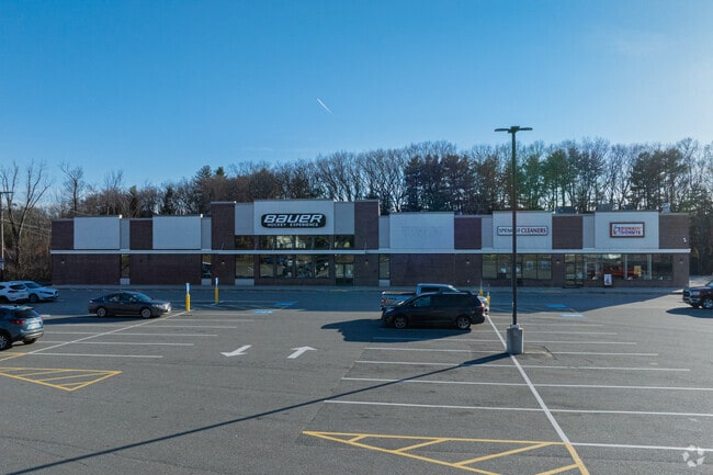
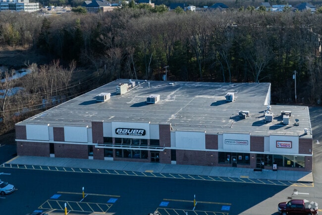
Property Record
240 Middlesex Tpke, Burlington, MA 01803

Current Lease Availabilities
Property Detail
240 Middlesex Tpke
Storebuilding
Middlesex
BG
Massachusetts
AE The base floodplain where base flood elevations are provided. AE Zones are now used on new format FIRMs instead of A1-A30 Zones.
2.75 AC
2025
Burlington/Woburn
2025
Boston
332402
Boston-Cambridge-Newton, MA-NH
27,174 SF
BURL-000026-000000-000021
NEARBY LISTINGS FOR SALE OR LEASE
DEMOGRAPHICS near 240 Middlesex Tpke
1 mile
3 mile
5 mile
2025 Total Population
5,054
56,490
155,922
2030 Population
5,264
58,820
162,200
Pop Growth 2025-2030
+ 4.16%
+ 4.12%
+ 4.03%
Average Age
41
43
42
2025 Total Households
1,943
20,446
57,116
HH Growth 2025-2030
+ 4.37%
+ 4.33%
+ 4.16%
Median Household Inc
$120,141
$148,776
$145,842
Avg Household Size
2.50
2.70
2.70
2025 Avg HH Vehicles
2.00
2.00
2.00
Median Home Value
$785,438
$803,594
$799,475
Median Year Built
1972
1970
1969
Nearby Places
Map Layers
Map Styles
 Street
 Aerial
Layers
 Traffic
 Biking
Places
Listings with unknown addresses are not visible on the map
- Restaurants
- Banks
- Shops
- Fitness
- Groceries
PUBLIC TRANSPORTATION
COMMUTER RAIL
Wilmington (Lowell Line - Massachusetts Bay Transportation Authority Commuter Rail (Purple Line))
Drive
Walk
Distance
Wilmington (Lowell Line - Massachusetts Bay Transportation Authority Commuter Rail (Purple Line))
11 min
5.5 mi
Anderson/Woburn Regional Transportation Center (Lowell Line - Massachusetts Bay Transportation Authority Commuter Rail (Purple Line))
Drive
Walk
Distance
Anderson/Woburn Regional Transportation Center (Lowell Line - Massachusetts Bay Transportation Authority Commuter Rail (Purple Line))
12 min
5.7 mi
AIRPORT
General Edward Lawrence Logan International
Drive
Walk
Distance
General Edward Lawrence Logan International
32 min
20.2 mi
Freight Ports
Port of Boston
Drive
Walk
Distance
Port of Boston
32 min
19.9 mi
Nearby Properties
Address
Land Use
TOTAL SIZE
Lot Size
Zoning
Address
Land Use
TOTAL SIZE
Lot Size
Zoning
72,799 SF
69.22 AC
IND
Address
Land Use
TOTAL SIZE
Lot Size
Zoning
135,300 SF
30.85 AC
PD
Address
Land Use
TOTAL SIZE
Lot Size
Zoning
35.90 AC
5
Address
Land Use
TOTAL SIZE
Lot Size
Zoning
388,978 SF
23.23 AC
RG
Address
Land Use
TOTAL SIZE
Lot Size
Zoning
37.77 AC
PD
Address
Land Use
TOTAL SIZE
Lot Size
Zoning
15.95 AC
BG
Address
Land Use
TOTAL SIZE
Lot Size
Zoning
23.91 AC
IG
Address
Land Use
TOTAL SIZE
Lot Size
Zoning
405,606 SF
33.40 AC
RO
Address
Land Use
TOTAL SIZE
Lot Size
Zoning
253,078 SF
4.18 AC
5
Address
Land Use
TOTAL SIZE
Lot Size
Zoning
346,106 SF
42.04 AC
RO
Address
Land Use
TOTAL SIZE
Lot Size
Zoning
330,500 SF
7.44 AC
PD
Address
Land Use
TOTAL SIZE
Lot Size
Zoning
32.07 AC
PD
Address
Land Use
TOTAL SIZE
Lot Size
Zoning
262,278 SF
3.80 AC
PD
Address
Land Use
TOTAL SIZE
Lot Size
Zoning
325,799 SF
21.70 AC
IND
Address
Land Use
TOTAL SIZE
Lot Size
Zoning
292,150 SF
17.76 AC
Address
Land Use
TOTAL SIZE
Lot Size
Zoning
30,480 SF
179 AC
A
Address
Land Use
TOTAL SIZE
Lot Size
Zoning
12.02 AC
IG
Address
Land Use
TOTAL SIZE
Lot Size
Zoning
281,240 SF
15 AC
IG
Address
Land Use
TOTAL SIZE
Lot Size
Zoning
11.70 AC
BG
Address
Land Use
TOTAL SIZE
Lot Size
Zoning
265,827 SF
10.38 AC
IH
Address
Land Use
TOTAL SIZE
Lot Size
Zoning
25.50 AC
BG
Address
Land Use
TOTAL SIZE
Lot Size
Zoning
100,271 SF
13.25 AC
CM
Address
Land Use
TOTAL SIZE
Lot Size
Zoning
6.69 AC
PD
Address
Land Use
TOTAL SIZE
Lot Size
Zoning
20,382 SF
11.61 AC
IND
Address
Land Use
TOTAL SIZE
Lot Size
Zoning
7.90 AC
PD
Address
Land Use
TOTAL SIZE
Lot Size
Zoning
14.82 AC
RO
Address
Land Use
TOTAL SIZE
Lot Size
Zoning
9.82 AC
PD
Address
Land Use
TOTAL SIZE
Lot Size
Zoning
216,224 SF
5.71 AC
NPD
Address
Land Use
TOTAL SIZE
Lot Size
Zoning
102,899 SF
28.88 AC
IND
The World's #1 Commercial Real Estate Marketplace
Connect with us
© 2026 CoStar Group
The information above has been obtained from sources believed reliable. While we do not doubt its accuracy we have not verified it and make no guarantee, warranty or representation about it. It is your responsibility to independently confirm its accuracy and completeness. Any projections, opinions, assumptions, or estimates used are for example only and do not represent the current or future performance of the property. The value of this transaction to you depends on tax and other factors which should be evaluated by your tax, financial, and legal advisors. You and your advisors should conduct a careful, independent investigation of the property to determine to your satisfaction the suitability of the property for your needs.