Property Record
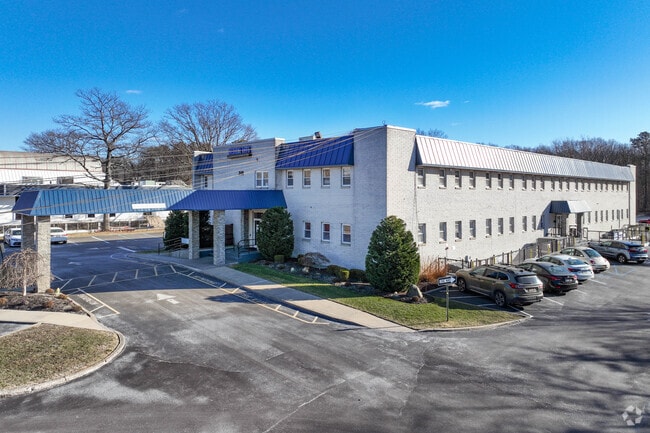
240 Patchogue Yaphank Rd, East Patchogue, NY 11772

Current Lease Availabilities
NEARBY LISTINGS FOR SALE OR LEASE
Property Detail
240 Patchogue Yaphank Rd
Nassau County-Suffolk County, NY
MEDICAL ARTS OF PATCHOGUE CONDO 403
0200-975-61-03-00-001-000
Suffolk
Commercialbuilding
New York
X
5
36103C0713H
0.16 AC
2024
Central Suffolk
2024
Long Island (New York)
159109
DEMOGRAPHICS near 240 Patchogue Yaphank Rd
1 Mile
3 Mile
5 Mile
2024 Total Population
6,470
66,511
125,453
2029 Population
6,363
65,806
124,281
Pop Growth 2024-2029
(1.65%)
(1.06%)
(0.93%)
Average Age
43
41
42
2024 Total Households
2,524
23,591
44,860
HH Growth 2024-2029
(2.26%)
(1.37%)
(1.14%)
Median Household Inc
$87,439
$100,256
$106,457
Avg Household Size
2.40
2.70
2.70
2024 Avg HH Vehicles
2.00
2.00
2.00
Median Home Value
$423,197
$416,870
$445,366
Median Year Built
1975
1972
1974
Nearby Places
Map Layers
Map Styles
 Street
 Aerial
- Restaurants
- Banks
- Shops
- Fitness
- Groceries
PUBLIC TRANSPORTATION
COMMUTER RAIL
Patchogue Station (Montauk Branch - Long Island Rail Road)
DRIVE
WALK
Distance
Patchogue Station (Montauk Branch - Long Island Rail Road)
6 min
2.6 mi
Bellport Station (Montauk Branch - Long Island Rail Road)
DRIVE
WALK
Distance
Bellport Station (Montauk Branch - Long Island Rail Road)
6 min
3.1 mi
AIRPORT
Long Island MacArthur
DRIVE
WALK
Distance
Long Island MacArthur
17 min
8.4 mi
Nearby Properties
Address
Land Use
TOTAL SIZE
Lot Size
Zoning
Address
Land Use
TOTAL SIZE
Lot Size
Zoning
3,278 SF
0.51 AC
VILLA
Address
Land Use
TOTAL SIZE
Lot Size
Zoning
3,942 SF
0.45 AC
VILLA
Address
Land Use
TOTAL SIZE
Lot Size
Zoning
3,960 SF
0.72 AC
R40
Address
Land Use
TOTAL SIZE
Lot Size
Zoning
2,946 SF
1.04 AC
R20
Address
Land Use
TOTAL SIZE
Lot Size
Zoning
28.97 AC
Address
Land Use
TOTAL SIZE
Lot Size
Zoning
1 AC
R40
Address
Land Use
TOTAL SIZE
Lot Size
Zoning
32.04 AC
Address
Land Use
TOTAL SIZE
Lot Size
Zoning
26.20 AC
Address
Land Use
TOTAL SIZE
Lot Size
Zoning
2,880 SF
0.40 AC
VB
Address
Land Use
TOTAL SIZE
Lot Size
Zoning
Address
Land Use
TOTAL SIZE
Lot Size
Zoning
8.30 AC
Address
Land Use
TOTAL SIZE
Lot Size
Zoning
0.80 AC
CR80
Address
Land Use
TOTAL SIZE
Lot Size
Zoning
19.01 AC
Address
Land Use
TOTAL SIZE
Lot Size
Zoning
0.98 AC
CR80
Address
Land Use
TOTAL SIZE
Lot Size
Zoning
2,444 SF
0.17 AC
VILLA
Address
Land Use
TOTAL SIZE
Lot Size
Zoning
32.52 AC
Address
Land Use
TOTAL SIZE
Lot Size
Zoning
0.02 AC
R40
Address
Land Use
TOTAL SIZE
Lot Size
Zoning
Address
Land Use
TOTAL SIZE
Lot Size
Zoning
1,828 SF
0.18 AC
VILLA
Address
Land Use
TOTAL SIZE
Lot Size
Zoning
5.62 AC
Address
Land Use
TOTAL SIZE
Lot Size
Zoning
Address
Land Use
TOTAL SIZE
Lot Size
Zoning
0.99 AC
Address
Land Use
TOTAL SIZE
Lot Size
Zoning
21.19 AC
Address
Land Use
TOTAL SIZE
Lot Size
Zoning
Address
Land Use
TOTAL SIZE
Lot Size
Zoning
12.09 AC
Address
Land Use
TOTAL SIZE
Lot Size
Zoning
8.34 AC
Address
Land Use
TOTAL SIZE
Lot Size
Zoning
9.25 AC
Address
Land Use
TOTAL SIZE
Lot Size
Zoning
37.51 AC
Address
Land Use
TOTAL SIZE
Lot Size
Zoning
65.86 AC
Address
Land Use
TOTAL SIZE
Lot Size
Zoning
The World's #1 Commercial Real Estate Marketplace
Connect with us
© 2025 CoStar Group
The information above has been obtained from sources believed reliable. While we do not doubt its accuracy we have not verified it and make no guarantee, warranty or representation about it. It is your responsibility to independently confirm its accuracy and completeness. Any projections, opinions, assumptions, or estimates used are for example only and do not represent the current or future performance of the property. The value of this transaction to you depends on tax and other factors which should be evaluated by your tax, financial, and legal advisors. You and your advisors should conduct a careful, independent investigation of the property to determine to your satisfaction the suitability of the property for your needs.