Property Record
240 Shelton Beard Rd, Stedman, NC 28391
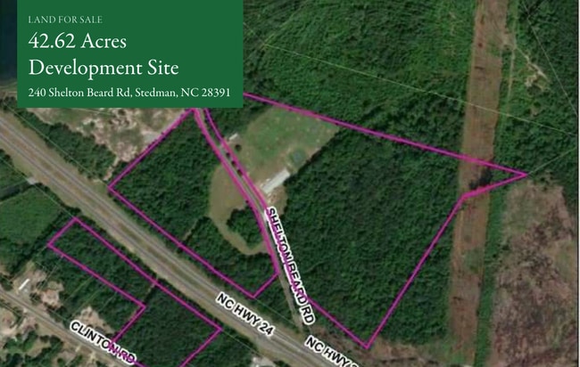

This Property Is For Sale
NEARBY LISTINGS FOR SALE OR LEASE
-
-
View all Stedman listings for sale on LoopNet.com
Property Detail
240 Shelton Beard Rd
Fayetteville, NC
Eastover Armstrong Stedman Dis
0476-77-6301
42.63 ACS LD
Realpropertynec
Cumberland
X
North Carolina
3720046600J
6301
2025
42.63 AC
2025
East Fayetteville
002801
Fayetteville
1,680 SF
DEMOGRAPHICS near 240 Shelton Beard Rd
1 Mile
3 Mile
5 Mile
2024 Total Population
402
7,087
15,537
2029 Population
405
7,112
15,621
Pop Growth 2024-2029
+ 0.75%
+ 0.35%
+ 0.54%
Average Age
39
39
40
2024 Total Households
147
2,636
5,986
HH Growth 2024-2029
+ 1.36%
+ 0.53%
+ 0.67%
Median Household Inc
$98,213
$91,416
$82,775
Avg Household Size
2.70
2.70
2.60
2024 Avg HH Vehicles
2.00
2.00
2.00
Median Home Value
$326,000
$314,589
$280,958
Median Year Built
1998
1996
1993
Nearby Places
Map Layers
Map Styles
 Street
 Aerial
- Restaurants
- Banks
- Shops
- Fitness
- Groceries
PUBLIC TRANSPORTATION
COMMUTER RAIL
Fayetteville Amtrak Station (Palmetto - Amtrak, Silver Meteor - Amtrak)
DRIVE
WALK
Distance
Fayetteville Amtrak Station (Palmetto - Amtrak, Silver Meteor - Amtrak)
14 min
8.8 mi
AIRPORT
Fayetteville Regional/Grannis Field
DRIVE
WALK
Distance
Fayetteville Regional/Grannis Field
21 min
12.6 mi
Freight Ports
Port of Wilmington
DRIVE
WALK
Distance
Port of Wilmington
129 min
88.0 mi
Nearby Properties
Address
Land Use
TOTAL SIZE
Lot Size
Zoning
Address
Land Use
TOTAL SIZE
Lot Size
Zoning
34,228 SF
45.88 AC
RR
Address
Land Use
TOTAL SIZE
Lot Size
Zoning
69,459 SF
25.38 AC
RR
Address
Land Use
TOTAL SIZE
Lot Size
Zoning
53,564 SF
9.81 AC
CP
Address
Land Use
TOTAL SIZE
Lot Size
Zoning
12,404 SF
16.46 AC
R10
Address
Land Use
TOTAL SIZE
Lot Size
Zoning
19,078 SF
30.41 AC
RR
Address
Land Use
TOTAL SIZE
Lot Size
Zoning
1,611 SF
4.54 AC
R40
Address
Land Use
TOTAL SIZE
Lot Size
Zoning
1,905 SF
11.07 AC
R20
Address
Land Use
TOTAL SIZE
Lot Size
Zoning
12,908 SF
21.37 AC
OIP
Address
Land Use
TOTAL SIZE
Lot Size
Zoning
4,500 SF
6.48 AC
CPCZ
Address
Land Use
TOTAL SIZE
Lot Size
Zoning
9,780 SF
73.62 AC
A1
Address
Land Use
TOTAL SIZE
Lot Size
Zoning
14,430 SF
1.85 AC
C2P
Address
Land Use
TOTAL SIZE
Lot Size
Zoning
3,576 SF
46.28 AC
R10
Address
Land Use
TOTAL SIZE
Lot Size
Zoning
7,028 SF
1.99 AC
R10
Address
Land Use
TOTAL SIZE
Lot Size
Zoning
6,661 SF
6.65 AC
A1
Address
Land Use
TOTAL SIZE
Lot Size
Zoning
22.22 AC
SF15C-SGLF
Address
Land Use
TOTAL SIZE
Lot Size
Zoning
6,000 SF
8.60 AC
C1
Address
Land Use
TOTAL SIZE
Lot Size
Zoning
1,204 SF
8.97 AC
C2P-CENTRA
Address
Land Use
TOTAL SIZE
Lot Size
Zoning
51.98 AC
PND
Address
Land Use
TOTAL SIZE
Lot Size
Zoning
4,299 SF
7.09 AC
A1-AGRI DI
Address
Land Use
TOTAL SIZE
Lot Size
Zoning
2,242 SF
3.60 AC
R6A
Address
Land Use
TOTAL SIZE
Lot Size
Zoning
8,028 SF
0.92 AC
R10
Address
Land Use
TOTAL SIZE
Lot Size
Zoning
533.40 AC
A1
Address
Land Use
TOTAL SIZE
Lot Size
Zoning
1,204 SF
2.44 AC
C2P-CENTRA
Address
Land Use
TOTAL SIZE
Lot Size
Zoning
2,040 SF
2.32 AC
C3
Address
Land Use
TOTAL SIZE
Lot Size
Zoning
6,240 SF
32.99 AC
R15
Address
Land Use
TOTAL SIZE
Lot Size
Zoning
4,692 SF
1.24 AC
RR
Address
Land Use
TOTAL SIZE
Lot Size
Zoning
4,388 SF
3.90 AC
R15
Address
Land Use
TOTAL SIZE
Lot Size
Zoning
13,200 SF
5.53 AC
CP
Address
Land Use
TOTAL SIZE
Lot Size
Zoning
11,160 SF
6.15 AC
M2
Address
Land Use
TOTAL SIZE
Lot Size
Zoning
6,871 SF
9.94 AC
R15
The World's #1 Commercial Real Estate Marketplace
Connect with us
© 2025 CoStar Group
The information above has been obtained from sources believed reliable. While we do not doubt its accuracy we have not verified it and make no guarantee, warranty or representation about it. It is your responsibility to independently confirm its accuracy and completeness. Any projections, opinions, assumptions, or estimates used are for example only and do not represent the current or future performance of the property. The value of this transaction to you depends on tax and other factors which should be evaluated by your tax, financial, and legal advisors. You and your advisors should conduct a careful, independent investigation of the property to determine to your satisfaction the suitability of the property for your needs.